St Asaph Street in the Central City, Christchurch

St Asaph Street in the Central City – Willis Street and Chaplin Street were incorporated into St Asaph Street. Named after the Anglican bishopric of St. Asaph in Wales from bishoprics listed in Burke’s Peerage. First mentioned in The Lyttelton Times in 1852 when 1/4 acre sections are advertised for sale there. Willis Street, running south off St Asaph Street in between Durham Street and Colombo Street, first appears in street directories in 1883. One of the residents is William Willis (b. 1840?), a carpenter. Re-named Chaplin Street in 1909 and incorporated into St Asaph Street in 1919. [The newspaper source has the name incorrectly spelt as Chaplain.

A reasonable amount of information from the library website. There was a huge amount of information on Papers Past so I have limited myself to pre 1900.There were sections for sale in 1850s and 1860s. Between 1860s and 1900 it was mostly birth and death notices. Sadly many of the death notices were for children. One of the many causes of children’s deaths was typhoid fever. This was a big problem due to Christchurch being built on a swamp. The United Methodist Free Church is mentioned frequently. A couple of well known family names from this street was Seager and Aulsebrook.

I actually walked the street in April 2021 and yes I am slightly behind in writing up this street. For certain very long streets I limited my walk to within the four avenues and will walk the Linwood part of the streets separately. This is why I have ignored Willis and Chaplin as they come under the Linwood part of the street.

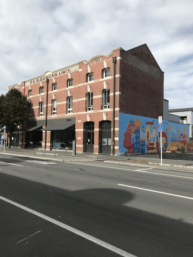
I started at Hagley Park where there are hospital buildings. There is the new Parakiore Recreation and Sports Centre is being built here as well. I did have fun watching the huge cranes on this site as I could see them from my house. There is a huge number of car salerooms on this street. Near Colombo St there is the Discovery School. Several restaurants and cafes in this part of the street. There is an interesting old building here and so far it has remained standing. A reasonable amount of street art on this street. Then it is Te Ara Polytechnic which has some interesting artwork. There are apartments opposite the polytechnic and I am not sure if they are student accommodation or not. The cycleway is looking fun here. Note most of St Asaph St has a cycleway along it which is fine if the cyclists would just use it. Note most are OK but you do get idiots who decide to cycle on the footpath and as I have had too many near misses when out walking I tend to become a grumpy old woman. If I am driving and it is a street that I frequently use when driving I get seriously annoyed with the cyclists who decide that they would much rather cycle in the the middle of the road.

There are some interesting buildings buildings near the Barbadoes St and Fitzgerald Ave ends of the street and they all seem to be cafes. There is one that I keep meaning to visit as I think that it is in an old convent that was on the corner of St Asaph St and Barbadoes St. One of the interesting buildings which is also a cafe I have no intention of visiting it assuming that they kept their license to operate.

When I returned home from the UK in 2014 I kept getting lost driving home on this street as the landmark of the brewery which was on the corner of St Asaph St and Antigua St had been demolished. I used to forget to turn down Antigua St.

Madras Street in the Central City, Christchurch

Madras Street in the Central City – Named after the colonial Anglican bishopric of Madras in India. One of the original streets of Christchurch named in 1850 by Captain Joseph Thomas (b. 1803?) and Edward Jollie (1825-1894). The names were taken from bishoprics listed in Burke’s Peerage. First mentioned in The Lyttelton Times in 1851. Madras Street, from North Belt (later Bealey Avenue) to Edgeware Road, became a public road in 1882 on subdivision by the Church Property Trustees of the Anglican Church, which owned much of the property in the area.

A reasonable amount of information from the library website and I found the 1851 ad in Papers Past.

I actually walked this street in May 2021 and I thought that I had already written it up. I was checking photos that I had transferred from my old laptop and then checked my Facebook and blog and realised that I had missed this street. I have a feeling that at the end of the walk that I popped into my son’s house and got him to drive me home as it was a very long walk or I walked home via Barbadoes St.

So many entries on Papers Past and most were ads. Seems to have been a street that has always had lots of businesses on it as not as many death notices as I would have expected. Most of the personal information about people was for the Sydenham end of the street. This part of the street became Gasson St in 1948. I did look at old maps but know can’t remember when Madras St was extended beyond Bealey Ave. In 1876 there were 80 sections in the area which included Madras St were made available by W Wilson. Note the land where the sections were was probably for sale as W Wilson was having a few issues like fraud and bankruptcy plus assault charges.

Some of the businesses were coal merchants, timber merchants, greengrocers and hotels. In 1902 a wooden building which housed a gymnasium was destroyed by fire along with Girton College plus houses either side were damaged. The fire brigade were blamed for being too slow. The gymnasium was in a building that was originally built by Worthington as a social hall for the Temple of Truth. Girton College was also erected by students of truth as a kindergarten. Over the decades St John’s Church and hall is frequently mentioned. The Salvation Army had a hall here as early as 1885. The Technical Institute was frequently mentioned and it is still there and I think it is now known as Te Ara Polytechnic. In the 1970s the YMCA building is mentioned and I remember this building but obviously demolished after the earthquakes.

When I walked the street I started at Moorhouse Ave end where the Polytechnic is and there are too many businesses for me to remember the names. There is a car park this end as well. There is a lot of empty land and near Latimer Square there is the CTV Memorial Garden. A few things that stood out were the clock tower and the fire fighters memorial near the bridge. As you walk closer to Bealey Ave and past Bealey Ave there are a huge number of apartments. Many of these were still being built when I actually walked the street. Most of these apartments were built between 1990 and 2022. Still some older houses dating back to 1910 and 1920s but most are looking very sad. I remember an interesting looking building on the corner of Madras St and Aberdeen St but when I checked google maps it seems to have gone. Just before you get to St Albans Park there is a huge empty section of land and it has been there for ages.

Cambridge Terrace in the Central City, Christchurch

Cambridge Tce in the Central City – Waterloo Terrace. Avonside Road was incorporated into Cambridge Terrace. Named after Cambridge University. Cambridge does not have a cathedral so this is out-of-step with the method used by Jollie and Thomas in naming other streets. One of the original streets of Christchurch named in 1850 by Edward Jollie (1825- 1894), and Captain Joseph Thomas (b. 1803?). The names were taken from bishoprics listed in Burke’s Peerage. On an 1879 map Cambridge Terrace West intersects Market Square (later Victoria Square). Waterloo Terrace was the name on the first plan of the road along the river [Avon] from Market Place to past the Foresters’ Hall ie. from near the Oxford-on-Avon and the Plunket Rooms around to near the Centennial Leisure Centre. (Buildings demolished after the 2010/2011 earthquakes). Avonside Road was the section just south of the Barbadoes Street Cemetery, adjacent to the river bank and the river, across the river from the Avon Loop, east of Barbadoes Street and round past Churchill Street to Fitzgerald Avenue. Incorporated into Cambridge Terrace.

A reasonable amount of information from the library website. Papers Past had thousands of entries so I made the decision to only look at the entries before 1900. Waterloo Terrace was only mentioned in connection with a new footbridge in 1852. The other mentions of Waterloo Terrace was in various articles in the 1930s when a document had been discovered mentioning it as the previous name for Cambridge Tce. I then sidetracked while I googled G H Wilson a curative mesmerist and medical galvanist who was living in Cambridge Tce in the 1860s and 1870s. There was a mention in 1929 about his cottage was still standing. Note he died in 1877. The Primitive Methodist Church laid the foundation stone for the church in 1873. There were sections for sale in 1878. In the 1870s and 1880s the Oddfellows Hall is mentioned. Drainage complaints were fairly frequent. I was amused by how many people had to pay fines for letting livestock roam especially horses and cows. The new public library opened in 1876. In 1871 there were dramatic headlines The Tragedy in Cambridge Terrace. I suggest you google Simon Cedeno. Huge number of sporting notices for the street.

I have probably missed a lot by limiting myself to pre 1900 but this was a very busy main street in Christchurch. It was also badly affected by the earthquakes with the fact that it follows the Avon River. I walks parts of this street frequently and in January last year I walked the street in its entirety. I started at the Antigua Street Boatsheds and near here there are a couple of houses dating from the 1930s. I then reached Cashel St and there is a few metres on Cashel St before rejoining Cambridge Tce. Now Cambridge Tce is slightly weird here as it runs between Durham St South and Durham St North and many people think that it is actually Durham St. The old library that was built in 1876 was in this section and I can vaguely remember it. There is a lovely old building along here which is called The Canterbury Club and on the opposite corner is the Harley Building. The Harley Building is in a dreadful state and has been closed since the earthquakes. There is then a big gap and I walked through Victoria Square to rejoin Cambridge Tce which is now a walkway. After Manchester St it is a road again briefly but just seems to be a place for people to park. Becomes a walkway again until after I cross Madras St. I then have to walk a few metres on Barbadoes St before rejoining Cambridge Tce where it becomes a road again. Walk past the Barbadoes St Cemetery and the street ends at Fitzgerald Ave. This end of the street has some lovely old houses and the oldest is from 1890 but my favourite is the one from 1900 as it is gorgeous. I seriously should have looked at old maps as I am sure that it didn’t use to be such a higgledy piggledy street. I took a huge amount of photos on my walk.

Queensbury Street in the Red Zone in the suburb of Burwood, Christchurch

Queensbury St in the red zone of Burwood – formerly Queen Street and Queensberry Street.Queen Street first appears in street directories in 1907. Queen Street and Queensberry Street both appear from 1913. Re-named Queensbury Street by the Waimairi County Council on 8 February 1933 when the problem of duplicate names was addressed with a number of streets.

A small amount of information from the library website.. Found the entry on Papers Past about changing the name from Queens St to Queensbury St but I actually wondered if they were two different streets and Queens St merged with Queenbury St. In 1921 there was a request for Queens St and Queensbury St to be signposted so that people could tell which street was which. Drainage issues are frequently mentioned. 1954 was a busy year as there were sections for sale and then there was more renaming of the street. Queensbury St North remained as Queensbury St. Then Queensbury St South between New Brighton Rd and McBratney’s Rd renamed Fleete St. Queensbury St South between McBratney’s Rd and Birchfield Ave renamed Madge St. I couldn’t find a Madge St and if you look at a map you will see how confusing this is.

In 1955 it was announced that State Housing will be built on Queensbury St. Papers Past show that some of the families who lived on the street were Reaby, Liggins and Goodman. The streets named after these three families run off Queensbury St.

I walked this street in January last year and obviously there are no longer any houses here. When I looked at street view most houses looked like they were 1950s and 1960s houses but a couple looked like 1920s cottages.

Parish Street in the Red Zone in the suburb of Burwood, Christchurch

Parish St in the Red Zone of Burwood – Named after Isaac Parish (1845?-1921). Parish worked with his father, William Parish, on the formation of Ferry Road and was later a farmer. He also served for some years on the Avon Road Board. He lived in a “beautifully situated homestead” on the corner of Lake Terrace Road and New Brighton Road. Name suggested by Councillor Liggins at a meeting of the Waimairi County Council on 26 October 1932. Formally named on 8 February 1933. First mentioned in street directories in 1934. First appears as a separate listing in 1955.

A reasonable amount of information from the library website. Most the entries on Papers Past were for a Parish St off Ferry Rd which is probably named after William Parish. Very few entries for Parish St in Burwood. A few death notices and ads. Isaac Parish was fined several times for not cooling his milk properly before selling it.

I actually walked this street in January last year and there are obviously no longer any houses here. Street view from 2012 shows the mess that the street was after the earthquakes.

Liggins Street in the Red Zone of the suburb of Burwood, Christchurch

Liggins St in Burwood Red Zone – Formerly Alfred Street. Named after HRH Prince Alfred Ernest Albert, Duke of Edinburgh & Saxe-Coburg Gotha (1844-1900). Re-named Liggins Street. Named after and by Joseph Liggins (1888- 1951) Alfred Street first appears in street directories in 1907. One of three streets named after Queen Victoria’s family. Prince Alfred was the second son of Queen Victoria and Prince Albert. Re-named Liggins Street by the Waimairi County Council on 8 February 1933. There is an Alfred Street in the central city. Liggins was a poultry farmer of 205 Queensbury Street, Burwood. He established the Canterbury Egg Farm and bred white leghorns. He was also a chairman of the Waimairi County Council. First appears in street directories in 1934.

A reasonable amount of information from the library website. Papers Past had so many entries for Alfred St as it was a very common street name that it was impossible to search. I narrowed my search to Alfred St Burwood and only found a couple of ads in 1921 for the sale of sections. In 1954 there were houses and sections for sale and that would possibly fit in with Joseph Liggins’s death in 1951. In the 1970s residents were concerned about flooding issues. I did find a name that I knew in an engagement notice in 1972.

I actually walked this street in January last year and there are obviously no longer any houses here. I checked google maps for street view and the street view for 2012 shows what a mess the street was after the earthquakes. Street view from 2007 show a street with houses that mostly looked like 1950s and 1960s styles. There was one interesting art deco house plus a house that looked like an older cottage.

Kingsford Street in the Red Zone in the suburb of Burwood, Christchurch

Kingsford St in Burwood Red Zone – Kingloch Street and King Street were amalgamated to form Kingsford Street. Named after Sir Charles Kingsford Smith (1897-1935). In 1895 the Avon Road Board was asked to metal a further portion of King Street, Windsor. King Street first appears in street directories in 1907, running from New Brighton Road to Mundys Road. Kingloch Street first appears in street directories in 1913, running from New Brighton Road to Alice Street. The two streets were amalgamated and renamed Kingsford Street by the Waimairi County Council on 8 February 1933 when the problem of duplicate names was addressed with a number of streets. Kingsford Smith was Australia’s greatest pioneer aviator. He and his co-pilot, Charles Ulm had made the first trans Tasman flight from Sydney to Christchurch on 10 September 1928. Begins the aviation theme of street names in the area.

A reasonable amount of information from the library website. Under the Kingloch name it was mostly death notices on Papers Past as well as lots of ads for produce including chickens, fruit and vegetables. Under King St it was mostly death notices. The article about the name changes was in 1932 when several streets had the names changed. In 1938 a man was fined for allowing his cattle to graze on the street. In 1951 there was talk about changing the name so that it included Queen rather than King. In 1956 the market gardens in the area were devastated by a big storm. In 1973 residents objected to a building at 34 Kingsford St being used for manufacturing purposes. The residents seemed to be an accident prone lot but this is possibly because they were close to a main road.

I walked this street in January last year and there are obviously no longer any houses here as it is in the red zone. I looked at 2007 on street view and most of the houses looked like brick houses from the 1950s and 1960s. Street view from 2012 showed a few houses still standing and the road was a mess.

Arahura Place in the suburb of Cashmere, Christchurch

Arahura Place in Cashmere and nothing on the library website. Possibly named after the river with the same name. The only information on Papers Past was several ads in 1975 offering sections. Most houses were built in 1970s and 1980s. This runs off Kidson Tce and I actually walked it in August 2020. I finally transferred photos from my old laptop to my new one and I probably need to be more organised with this project. It is a very narrow street with no footpath. Houses would have fairly good views over Christchurch. None really stood out for me and weirdly I only took a photo of letterboxes which were at the beginning of the street.

Oakford Close in the suburb of Riccarton, Christchurch

Oakford Close in Riccarton – Named after Oakford, a large house originally on eight acres of land laid out in garden on the corner of Riccarton Road and Mandeville RoadThe house was built in 1857, on a 20 hectare block on the southern side of Lower Riccarton Road, by Henry Joseph Hall (1837- 1897). Later owners were: Nelson King Cherrill (1845-1916), a photographer, and George Low Beath (1827-1914), a draper and outfitter. The last owner was John Heaton Rhodes (1888- 1960), a lawyer and the chairman of the Christchurch Press Company Ltd. for 24 years. The house was demolished in 1965 to make way for a motel development. Named in 1997.

A reasonable amount of information on the library website. The owner of the house died in 1960 and in 1965 the house was demolished. I don’t know if the motels were ever built but in 1997 approval was granted to a developer to build 55 apartments and townhouses. A reasonable footpath here but parking would be terrible. This street runs off Deans Ave and I couldn’t decide if I would like to live here or not. The street might be called Oakford Close but the complex is called Kirkstyle Estate.

Palazzo Lane in the suburb of Riccarton, Christchurch

Palazzo Lane in Riccarton and nothing on library website. I thought that the reason why it wasn’t on the library website was because the street is too new but most of the houses were built in 1990s. One meaning of palazzo is Italian for palatial. I wasn’t very comfortable walking this street and stopped when I ran out of footpath. The houses here are huge and extremely expensive. Well beyond my budget. The lane runs off Deans Ave.