Dalefield Drive in Cashmere and it isn’t on the library website. There were a few mentions on Papers Past and it looks like it was a new street in 1978. By special order that the underwidth road to be known as Dalefield Drive is a summary of the article. Most houses were built in the 1970s and 1990s but there is one house from 1930s. The 1930s house was at the end of the street and impossible to see it from the road. I suspect that the street was named after a person as there were several people with that surname living in Christchurch. I just couldn’t find anyone with that name living on Bowenvale Ave. There was a footpath on only side of the street which is unusual for a street developed in the 1970s but this is probably because it was considered underwidth. Looked like a pleasant street.
Torvill and Dean Lane in the suburb of Cashmere, Christchurch
Torvill and Dean Lane in Cashmere – Named after Jayne Torvill (1957-) and Christopher Dean (1958-).Torvill and Dean were famed for their ice dancing, winning a gold medal at the 1984 Winter Olympics. Developed on the former site of Ice Rinks Christchurch Ltd., 12 Centaurus Road, Cashmere. First appears in street directories in 1991.
A reasonable amount of information from the library website. Who is old enough to remember the ice skating rink. I have the most dreadful photo of me at the ice skating rink plus I wasn’t very good at ice skating. Most of the houses here were built in the 1980s and mostly seem to be made from brick. Nothing really stood out for me.
Waltham Road in the suburb of Sydenham, Christchurch
Waltham Road in Sydenham – Formerly Gasworks Road. Named because the Gasworks were there. Also Langdown Street. Re-named Waltham Road. Named, as the suburb is named, after Waltham House, a large house on Colombo Road belonging to Charles Prince.Gasworks Road is first mentioned in the Star in 1871 and appears on an 1879 map. Waltham Road is mentioned in street directories of 1878 so the street had alternate names for a time. In 1889 the council proposed re-naming the road Langdown Street to honour a retiring mayor, William Langdown (1827-1903). It appears on an 1890 map as Langdown Street. According to an 1890 newspaper report this name was rejected by residents. However, from 1905 to 1948, the section from Austin Street to the bridge at Wilsons Road was known as Langdown Street. There had once been lime kilns in the street named Langdown & Co.
A reasonable amount of information from the library website. Papers Past had a huge number of entries which included lots of death notices and a few birth notices. Both Gasworks Rd and Waltham Rd were used at the same time and there was also a Gasworks Rd in Lyttelton. Frequent complaints about the state of the road. Because of the huge number of articles I mainly looked at articles pre 1900. Some of the businesses and buildings in the street were Reese’s Store, Innes Brewery, Langdowns, Oddfellows Hall, the old public library and of course the gasworks. I don’t know when Waltham school was opened but I found a mention in 1896.
In 1889 when it was announced that the name was changing to Langdown St there was an outcry about it with a petition against it. In the end only part of the street was named Langdown St and it went from Austin St to Wilsons Rd. This part was still Langdown St on maps until 1950.
A letter to the editor in 1866 amused me as it was headed Mr Prince and the Waltham Hoax. The residents had agreed for the suburb to be called Waltham after Charles Prince’s house Waltham House. Sydenham is supposed to be named after Charles Prince’s shop on Colombo St which was called The Sydenham China Shop. The other theory is that it was named after his teaching academy called Sydenham Academy and this was next door to his shop. He possibly was bankrupt in 1867 and there was a meeting of his creditors. Surprising how many streets in Christchurch are named after men who had financial issues.
One business that I looked at was Urlwin Industries as I remember the business and it was a huge building right on the corner opposite Austin St. I hadn’t realised that it started originally in the central city until it had a fire in 1939. In 1946 the address for the factory was Langdown St. I do remember when it was destroyed by fire in 1965 and apparently many local residents objected to it being rebuilt. In 1968 the company was taken over by PDL and I think that the owner had either retired or died. The reason that this is so clear in my memory is that an uncle worked at the company and Uncle Harry also lived just around the corner from the factory. We would drive past the factory on our way home to Lyttelton and it was over the hills those days.
I also remember the gasworks and I am not sure when it was demolished. It was definitely still there when I used to catch the school train.
I started my walk today near the river and the first big building is the Waltham Swimming Pool. Then it is Waltham Park where there is street art on the toilet buildings. There are houses on the other side of the street and there are many older houses at this end. Where Urlwin’s / PDL factory used to be situated there is a huge number of apartments which were mostly built in 2016 and 2017. The houses then become a mixture of new and old houses plus there is Waltham School. There is also social housing. Between Brougham St and Moorhouse Ave it is mostly businesses. The house from 1880 is looking very sad but the one from 1890 is looking lovely.

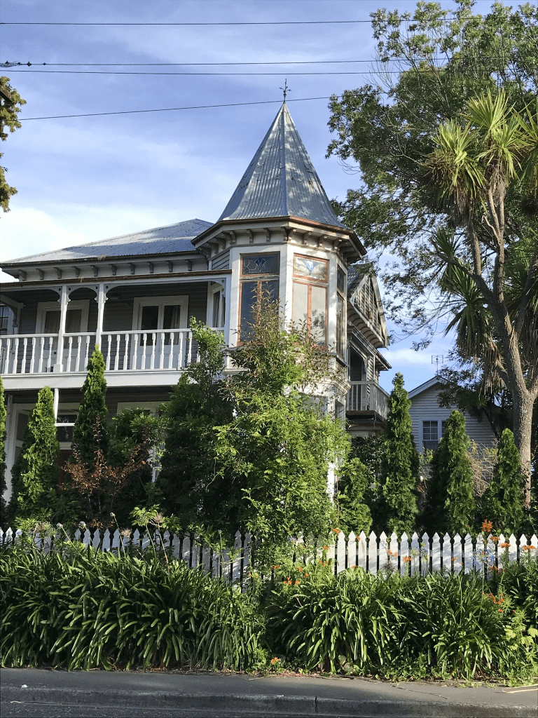
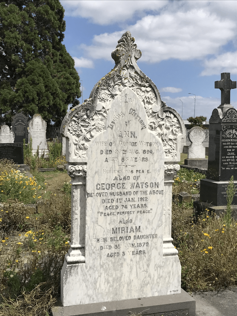
Watsons Road in the suburb of Harewood, Christchurch
Watsons Rd in Harewood – formerly Watson’s Road. Named after George Watson (1837-1912). Watson, a farmer, is first listed in electoral rolls in the Styx catchment in 1878-1879 and is
described as having a leasehold on Rural Section 57 on the south side of Harewood Road. He later owned land on its north side. He is buried at St James Anglican Church in Harewood Road. Tenders were accepted by the Waimairi County Council for the “forming and shingling” of Watson’s Road in 1911. Formally named in 1917.
A reasonable amount of information from the library website. When looking at Papers Past there was at least three Watsons Roads in the Christchurch area. A few death notices and the earliest entry that I found was dated 1916. In 1957 and 1958 there were several articles about the zoning of the land. It was to be zoned rural because of the airport and any work subdivisions under 5 acres were prohibited. In 1965 a large block of land belonging to the late William Nunweek sold for a very good sum. In 1973 a Professor E R Hudson talked about living on a property on this road. It was apparently once a dairy farm and during World War Two they grew vegetables for the troops on the land.
In the 1970s it was mostly ads for two fruit farms. Coniston was at 51 Watsons Rd and the other one was Honeysuckle Fruit Farm.
George Watson died in 1912 and he lived on Harewood Rd until 5 years before his death. The road would have been formed through his property.
Being a rural road there wasn’t a footpath but the grass verge was fairly wide. There was a cluster of houses at the Waimakariri Rd end of the street and then it was large rural properties. Wai Ora Trust looked like a market gardening business and then there was a B&B. There was a gorgeous looking house on a huge section of land but technically it wasn’t on Watsons Rd as it had a Harewood Rd address. The property was called Omarino Wine Park and it was a wedding venue. There was an entrance on Watsons Rd. I couldn’t find out the age of the building but it looked 1900 to 1920ish but the Wine Park website said that they had a modern new venue built since the earthquakes.
Whitchurch Place in the suburb of Harewood, Christchurch
Whitchurch Place in Harewood – Named because it runs behind St James Anglican Church in Harewood Road. Named in 1970. [Boeing Place was another name suggested because of the street’s proximity to Christchurch Airport.]
A small amount of information from the library website. Very little information on Papers Past. Mentioned as a new street in 1970 and in 1972 a new well was mentioned.
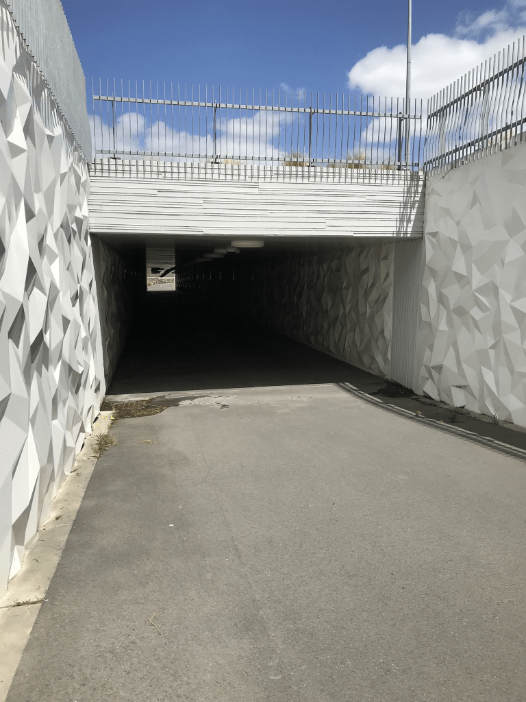
Apart from the church which is technically on Harewood Rd there are only three properties here. I couldn’t see the one from 1916 as it was down a long driveway. The Asian Garden Cooking School took up a large part of the street. The church has a carpark entrance on this street but if you look at old street views this carpark is fairly recent. Google maps show a bit change in the street between 2008 and 2022. At the end of the street there is now a subway that takes you under the extremely busy main road. Lovely wee church and cemetery here. My first thought when I saw the name of the street was that it would have been named after a place in the UK. There are at least three places with that name in the UK.
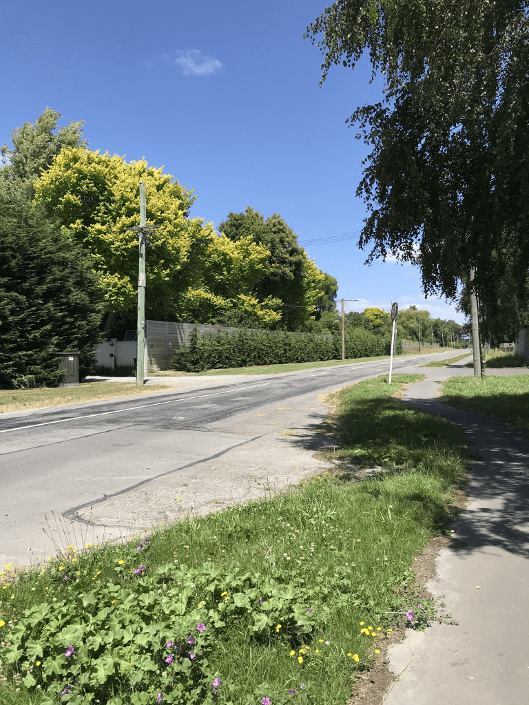
Waimakariri Rd in the suburb of Harewood, Christchurch
Waimakariri Rd in Harewood – formerly Part of Johns Road. Named because at one time the whole of Johns Road was known as the Waimak Road. First appears in street directories in 1972. [Kilcroft Road was another name suggested.]
A small amount of information from the library website. I didn’t find the name Kilcroft on Papers Past. The earliest entry that I found for Waimakariri Rd was in 1916 under Roll of Honour. Waimak Rd was mostly only used in the 1920s. The was land for sale in 1926 and described as suitable for market gardening. More land was available in 1956. Lots of ads for selling potatoes. Some entries said Harewood and other entries said Belfast or Styx. I will have to have another look at the older maps as the one from 1974 shows it very clearly as Waimakariri Rd and Johns Rd finishing at Sawyers Arms Rd. Map from 1922 shows it all as one road but modern maps show Johns Rd as extending past Sawyers Arms Rd. There seems to have been a reasonable amount of road changes in the area over the years.
I walked this street today after geocaching in the area and I was surprised to find that I had a footpath to be able to walk on. It was actually a really pleasant walk. Not many houses here and they all sit on large tracts of land. Most seem to have been built in the 1960s but one dates from 1915. There is apparently superior airport parking here but when walking past I actually thought that the property had originally been a domain because that was what it looked. One property looked like it was growing Christmas trees. Another old property I couldn’t see very well because of the vegetation surrounding it but it looked like an old workers cottage. At the Sawyers Arms Rd end the fences surrounding the properties were extremely tall. My best guess for the reason for such fences is for blocking traffic noise. I was surprised to see very little sign of boy racers as I would have thought that it would have been a prime target for such idiots. At one part the map looked there was another road leading off this road but it was just the entrance way to a car distribution business.
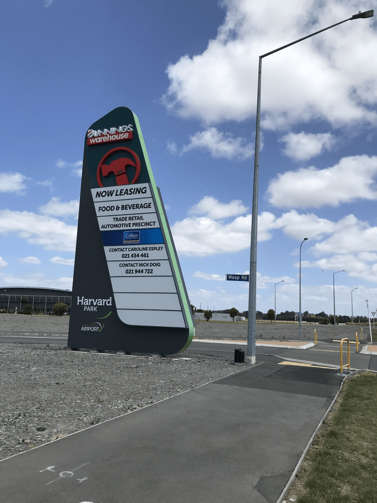
Wasp Road in the suburb of Harewood, Christchurch
Wasp Road in Harewood – too new to be on library website and too new to be on google maps but weirdly it is on apple maps. It runs between Harewood Rd and Walrus Rd near Orchard Rd. It is in the middle of a big empty section. Couldn’t find any information when googling. It is probably named after the wasp fighter jet.
St Asaph Street in the Central City, Christchurch
St Asaph Street in the Central City – Willis Street and Chaplin Street were incorporated into St Asaph Street. Named after the Anglican bishopric of St. Asaph in Wales from bishoprics listed in Burke’s Peerage. First mentioned in The Lyttelton Times in 1852 when 1/4 acre sections are advertised for sale there. Willis Street, running south off St Asaph Street in between Durham Street and Colombo Street, first appears in street directories in 1883. One of the residents is William Willis (b. 1840?), a carpenter. Re-named Chaplin Street in 1909 and incorporated into St Asaph Street in 1919. [The newspaper source has the name incorrectly spelt as Chaplain.
A reasonable amount of information from the library website. There was a huge amount of information on Papers Past so I have limited myself to pre 1900.There were sections for sale in 1850s and 1860s. Between 1860s and 1900 it was mostly birth and death notices. Sadly many of the death notices were for children. One of the many causes of children’s deaths was typhoid fever. This was a big problem due to Christchurch being built on a swamp. The United Methodist Free Church is mentioned frequently. A couple of well known family names from this street was Seager and Aulsebrook.
I actually walked the street in April 2021 and yes I am slightly behind in writing up this street. For certain very long streets I limited my walk to within the four avenues and will walk the Linwood part of the streets separately. This is why I have ignored Willis and Chaplin as they come under the Linwood part of the street.
I started at Hagley Park where there are hospital buildings. There is the new Parakiore Recreation and Sports Centre is being built here as well. I did have fun watching the huge cranes on this site as I could see them from my house. There is a huge number of car salerooms on this street. Near Colombo St there is the Discovery School. Several restaurants and cafes in this part of the street. There is an interesting old building here and so far it has remained standing. A reasonable amount of street art on this street. Then it is Te Ara Polytechnic which has some interesting artwork. There are apartments opposite the polytechnic and I am not sure if they are student accommodation or not. The cycleway is looking fun here. Note most of St Asaph St has a cycleway along it which is fine if the cyclists would just use it. Note most are OK but you do get idiots who decide to cycle on the footpath and as I have had too many near misses when out walking I tend to become a grumpy old woman. If I am driving and it is a street that I frequently use when driving I get seriously annoyed with the cyclists who decide that they would much rather cycle in the the middle of the road.
There are some interesting buildings buildings near the Barbadoes St and Fitzgerald Ave ends of the street and they all seem to be cafes. There is one that I keep meaning to visit as I think that it is in an old convent that was on the corner of St Asaph St and Barbadoes St. One of the interesting buildings which is also a cafe I have no intention of visiting it assuming that they kept their license to operate.
When I returned home from the UK in 2014 I kept getting lost driving home on this street as the landmark of the brewery which was on the corner of St Asaph St and Antigua St had been demolished. I used to forget to turn down Antigua St.
Madras Street in the Central City, Christchurch
Madras Street in the Central City – Named after the colonial Anglican bishopric of Madras in India. One of the original streets of Christchurch named in 1850 by Captain Joseph Thomas (b. 1803?) and Edward Jollie (1825-1894). The names were taken from bishoprics listed in Burke’s Peerage. First mentioned in The Lyttelton Times in 1851. Madras Street, from North Belt (later Bealey Avenue) to Edgeware Road, became a public road in 1882 on subdivision by the Church Property Trustees of the Anglican Church, which owned much of the property in the area.
A reasonable amount of information from the library website and I found the 1851 ad in Papers Past.
I actually walked this street in May 2021 and I thought that I had already written it up. I was checking photos that I had transferred from my old laptop and then checked my Facebook and blog and realised that I had missed this street. I have a feeling that at the end of the walk that I popped into my son’s house and got him to drive me home as it was a very long walk or I walked home via Barbadoes St.
So many entries on Papers Past and most were ads. Seems to have been a street that has always had lots of businesses on it as not as many death notices as I would have expected. Most of the personal information about people was for the Sydenham end of the street. This part of the street became Gasson St in 1948. I did look at old maps but know can’t remember when Madras St was extended beyond Bealey Ave. In 1876 there were 80 sections in the area which included Madras St were made available by W Wilson. Note the land where the sections were was probably for sale as W Wilson was having a few issues like fraud and bankruptcy plus assault charges.
Some of the businesses were coal merchants, timber merchants, greengrocers and hotels. In 1902 a wooden building which housed a gymnasium was destroyed by fire along with Girton College plus houses either side were damaged. The fire brigade were blamed for being too slow. The gymnasium was in a building that was originally built by Worthington as a social hall for the Temple of Truth. Girton College was also erected by students of truth as a kindergarten. Over the decades St John’s Church and hall is frequently mentioned. The Salvation Army had a hall here as early as 1885. The Technical Institute was frequently mentioned and it is still there and I think it is now known as Te Ara Polytechnic. In the 1970s the YMCA building is mentioned and I remember this building but obviously demolished after the earthquakes.
When I walked the street I started at Moorhouse Ave end where the Polytechnic is and there are too many businesses for me to remember the names. There is a car park this end as well. There is a lot of empty land and near Latimer Square there is the CTV Memorial Garden. A few things that stood out were the clock tower and the fire fighters memorial near the bridge. As you walk closer to Bealey Ave and past Bealey Ave there are a huge number of apartments. Many of these were still being built when I actually walked the street. Most of these apartments were built between 1990 and 2022. Still some older houses dating back to 1910 and 1920s but most are looking very sad. I remember an interesting looking building on the corner of Madras St and Aberdeen St but when I checked google maps it seems to have gone. Just before you get to St Albans Park there is a huge empty section of land and it has been there for ages.
Cambridge Terrace in the Central City, Christchurch
Cambridge Tce in the Central City – Waterloo Terrace. Avonside Road was incorporated into Cambridge Terrace. Named after Cambridge University. Cambridge does not have a cathedral so this is out-of-step with the method used by Jollie and Thomas in naming other streets. One of the original streets of Christchurch named in 1850 by Edward Jollie (1825- 1894), and Captain Joseph Thomas (b. 1803?). The names were taken from bishoprics listed in Burke’s Peerage. On an 1879 map Cambridge Terrace West intersects Market Square (later Victoria Square). Waterloo Terrace was the name on the first plan of the road along the river [Avon] from Market Place to past the Foresters’ Hall ie. from near the Oxford-on-Avon and the Plunket Rooms around to near the Centennial Leisure Centre. (Buildings demolished after the 2010/2011 earthquakes). Avonside Road was the section just south of the Barbadoes Street Cemetery, adjacent to the river bank and the river, across the river from the Avon Loop, east of Barbadoes Street and round past Churchill Street to Fitzgerald Avenue. Incorporated into Cambridge Terrace.
A reasonable amount of information from the library website. Papers Past had thousands of entries so I made the decision to only look at the entries before 1900. Waterloo Terrace was only mentioned in connection with a new footbridge in 1852. The other mentions of Waterloo Terrace was in various articles in the 1930s when a document had been discovered mentioning it as the previous name for Cambridge Tce. I then sidetracked while I googled G H Wilson a curative mesmerist and medical galvanist who was living in Cambridge Tce in the 1860s and 1870s. There was a mention in 1929 about his cottage was still standing. Note he died in 1877. The Primitive Methodist Church laid the foundation stone for the church in 1873. There were sections for sale in 1878. In the 1870s and 1880s the Oddfellows Hall is mentioned. Drainage complaints were fairly frequent. I was amused by how many people had to pay fines for letting livestock roam especially horses and cows. The new public library opened in 1876. In 1871 there were dramatic headlines The Tragedy in Cambridge Terrace. I suggest you google Simon Cedeno. Huge number of sporting notices for the street.
I have probably missed a lot by limiting myself to pre 1900 but this was a very busy main street in Christchurch. It was also badly affected by the earthquakes with the fact that it follows the Avon River. I walks parts of this street frequently and in January last year I walked the street in its entirety. I started at the Antigua Street Boatsheds and near here there are a couple of houses dating from the 1930s. I then reached Cashel St and there is a few metres on Cashel St before rejoining Cambridge Tce. Now Cambridge Tce is slightly weird here as it runs between Durham St South and Durham St North and many people think that it is actually Durham St. The old library that was built in 1876 was in this section and I can vaguely remember it. There is a lovely old building along here which is called The Canterbury Club and on the opposite corner is the Harley Building. The Harley Building is in a dreadful state and has been closed since the earthquakes. There is then a big gap and I walked through Victoria Square to rejoin Cambridge Tce which is now a walkway. After Manchester St it is a road again briefly but just seems to be a place for people to park. Becomes a walkway again until after I cross Madras St. I then have to walk a few metres on Barbadoes St before rejoining Cambridge Tce where it becomes a road again. Walk past the Barbadoes St Cemetery and the street ends at Fitzgerald Ave. This end of the street has some lovely old houses and the oldest is from 1890 but my favourite is the one from 1900 as it is gorgeous. I seriously should have looked at old maps as I am sure that it didn’t use to be such a higgledy piggledy street. I took a huge amount of photos on my walk.