Landsdowne Terrace in the suburb of Cashmere, Christchurch

Landsdowne Tce in Cashmere – First appears in street directories in 1964.

A tiny amount of information from the library website. Most entries on Papers Past were ads for sections in 1966 but there was one interesting article from 1963. The secretary of the Historic Places Trust Christchurch branch requested that the name of the street be changed as it was misleading. This obviously didn’t happen. Reason for the request was that the property developer was promoting the various subdivisions in the area as having great views over Bowenvale Valley and Landsdowne Valley. Landsdowne Valley is miles away and closer to Halswell than Cashmere so I could see his point. In 1972 plans for a Community Centre were discussed and a site on this street had been selected. In September 1976 the Community Centre was opened. There was another Landsdowne Tce in Dallington in 1919 and I remember this from one of the Dallington streets that I walked a couple of months ago.

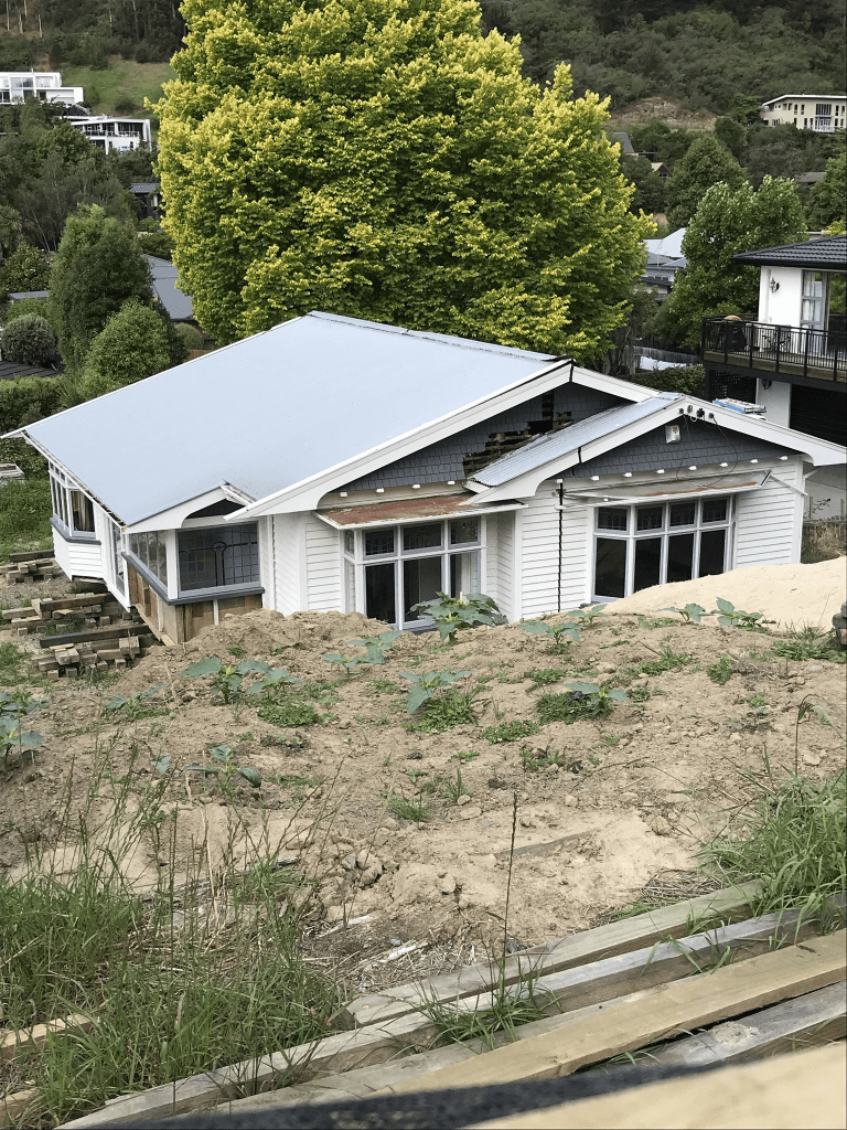
I walked this street in the early evening last night and it looks like a pleasant street. Most houses were built in the 1960s and 1970s and none of them stood out for me but many had lovely gardens. There are still a few gaps from where houses were demolished after the earthquakes. In one gap there is a house that has been relocated to the site. It is a 1920s wooden villa and it wasn’t there when I checked street view for September 2022. It looks very similar to a house that was recently removed from Strickland St. The drivers of those huge vehicles are amazing and watching the one on Strickland St made me appreciate their skill. There are a couple of ugly rebuilds but one house that took my eye was a fairly ordinary house with blue shutters. When I checked it was a house built in the 1940s which is 20 years before the street was created. I am getting very good at guessing the ages of houses just by the style of the house.

I used to visit this street in the 1980s as I had friends who lived there. Sadly he died in 1988 at the age of 37 leaving a young family and when walking the street last night I just couldn’t remember which house it was.

Kanuku Place in the suburb of Cashmere, Christchurch

Kanuku Place in Cashmere and there wasn’t anything on the library website yet this was a subdivision in 1963. It was mostly ads for sections on Papers Past plus a couple of death notices. Described as part of the Cashmere Downs subdivision.

None of the houses stood out for me and they were fairly typical for the 1960s. What I did like was the trees as the branches on them would be perfect for hanging books from. I haven’t done a book tree in ages. I meant to have done a themed Friday the 13th one yesterday and forgot.

Gunns Crescent in the suburb of Cashmere, Christchurch

Gunns Crescent in Cashmere – Named after the Scottish clan from which Sir John Cracroft Wilson (1808-1881) descended. Clan Gunn is a Scottish clan associated with north-eastern Scotland. First appears in street directories in 1968.

A small amount of information from the library website and nothing that I can add to it. There were sections for sale in 1966 and it was called Cashmere Downs subdivision. other ads for the sections called it Cracroft Wilson block. These ads were the main entries on Papers Past. There are 40 houses here and most were built in the 1960s with a few built in 1970s. A couple were more recent builds. There was a big house on a back section that looked interesting but I couldn’t get a good view of it.

Glamis Place in the suburb of Cashmere, Christchurch

Glamis Place in Cashmere – Named after Glamis, a castle in Scotland. First appears in street directories in 1966.

A tiny amount of information from the library website and nothing that I can add about the name of the street. I think that I have visited this castle in Scotland.

Most houses were built in the 1960s and 1970s with a couple built more recently. Most entries in Papers Past were ads for sections in 1968 and 1969. Nothing really stood out for me on this street but one of the new houses was rather ugly. The other just looked different. The footpath was on both sides of the street which is always a good thing.

Emerald Lane in the suburb of Cashmere, Christchurch

Emerald Lane in Cashmere and there was nothing on library website about it. Most houses were built in the 2000s. I ended up chatting to one of the residents and he said that it had been a market garden with lots of glasshouses before it was subdivided. It is possible that it was named after a hebe called Emerald Gem.

Scarff Place in the suburb of Cashmere, Christchurch

Scarff Place in Cashmere – Named after Walter William Prideaux Scarff (1880?-1944). Scarff was a member of the Heathcote County Council 1914- 1935 and, for a time, chairman. He was county inspector from 1935 until his death. First appears in street directories in 1995.Information supplied in 2007 by Alan Copping, a grandson of Walter Scarff, in an interview with Margaret Harper.

A small amount of information from the library website. I checked ancestry website and Prideaux was his mother’s maiden name.

A lot of information on Papers Past about Walter Scarff’s council work but the saddest information that I found was about his daughter. In 1927 Gwendoline Scarff was found murdered in Burwood. A taxi driver who had been her lover was arrested and he was charged with her murder and also charged with giving her a drug. The wording about the drug was rather strange but I found a court document on ancestry website which explained the strange wording. The drug was apparently for procuring an abortion. The man accursed was a married man with two children. He was found not guilty and it looks like he moved to Australia with his family.

Only 12 houses on this street and most were built in the 1990s. A variety of styles and the houses were huge. At the end of the street there is the start to the Latters Spur Track.

Barrer Lane in the suburb of Cashmere, Christchurch

Barrer Lane in Cashmere – Named after Bryan Amherst Barrer (1908-1980) and his wife, Margaret (1916-1982). The Barrers owned several acres of flat tussock land behind Queen Elizabeth II Park in Victoria Park Road which they landscaped, naming the property Four Winds. The property was subdivided after Mrs Barrer’s death. First appears in street directories in 1995.

A small amount of information from the library website and there is a mistake in the information. The park is actually called Elizabeth Park and it is named after the queen but has never been known as Queen Elizabeth II Park.

Bryan and Margaret’s daughter still lives here and she has named her house Four Winds but it isn’t the original house. Her parents were passionate about trees and plants and their daughter Jennifer is just as passionate. As well as her house Jennifer has about an acre of land planted mostly in native bush. Recently someone has been trespassing onto her land and poisoning the trees which she is very upset about. Jennifer is passionate about social history and she also is a poet. You can find her books at the library. Jennifer said her father was a wonderful and caring man. She went mountain climbing with him from a very young age. Last time I had caught up with Jennifer was at an open day at the Ngaio Marsh house which was about three years ago. We had a good natter today and she liked the sound of my street project.

Amherst Place in the suburb of Cashmere, Christchurch

Amherst Place in Cashmere – Named after Bryan Amherst Barrer (1908-1980) Barrer was a lawyer and foundation member of the Canterbury Mountaineering Club. First appears in street directories in 1978.

A small amount of information from the library website. There were a few entries on Papers Past and they were about the subdivision in 1974. There were 7 sections being sold by B A Barrer and Company. A street with great views but none of the houses stood out for me.

Harry Ell Drive in the suburb of Cashmere, Christchurch

Harry Ell Drive in Cashmere – Named after Henry George “Harry” Ell (1862-1934). Ell was a prohibitionist, parliamentarian 1899- 1919, conservationist and an advocate of the establishment of a string of reserves along the Port Hills. First appears in street directories in 1990.

A small amount of information from the library website and nothing that I can add about the name.

The views from this street are fantastic and every house is built to take advantage of the views. Most of the houses were apparently built in the 1970s so I would have expected it to have been in street directories much earlier than 1990. So many different styles of houses and some I liked and some where toilet block style. They are all well beyond my budget unless someone would like to give me a million or two. There was one house at the top that I loved but I couldn’t get a decent view because of the trees surrounding. I did find a photo online on an official website that was taken in 2007 before the trees grew but because of copyright I couldn’t copy it. I was hoping that street view would show it but it didn’t.

There is someone who is poisoning trees that belong to an elderly woman. The trees are on her private land and it is mostly native bush much of which was planted by her late father. It is possible that the person doing this lives on this street.

Derrynane Lane in the suburb of Cashmere, Christchurch

Derrynane Lane in Cashmere – nothing on library website. Derrynane is a village in Ireland and it was also the name of the ship. Couldn’t find out anything about this tiny street. There are only about 4 houses here built in 1990s.

Another one that I have managed to do twice and I have a feeling that in 2019 that I came up through Longhurst Reserve as I remember that I was geocaching in the reserve in 2019.