Henry St in Waltham – Named after Henry Wilson. Wilson was the fourth son of William Barbour Wilson (1819-1897), nurseryman, businessman and local politician, and his wife, Elizabeth. He married Charlotte Cox of Featherston. He was in the hardware trade in Christchurch for a number of years and died in England. In a subdivision of Rural Section 48, land owned by William Wilson (1819-1897). Henry Street appears on an 1874/75 Deposit Plan. First appears in street directories in 1913. Plan of suburban property (Rural Section 48) situated on the Ferry Road near the East Town Belt belonging to William Wilson Esq., Deposit Plan 27 1874/75. Map held by Bob Pritchard, subdivisions officer, Christchurch City Council. [The land, 200 acres in Ferry Road, had originally been purchased by G. Draper and his son in law, James Edward FitzGerald (1818?-1896).]
A reasonable amount of information from the library website. I didn’t manage to get much information from Papers Past as there was a huge number of streets with the name Henry Street. A few entries using Opawa and Linwood but nothing using Waltham. A few death notices and recruitment notices. From 1950s onwards all the entries were for a business called Lomak Furniture including a big fire in 1974. It was also impossible to find any information about Henry Wilson on Papers Past thanks to a Sir Henry Wilson being assassinated. The ancestry website was of no help at all. All the family trees for this man had his father as William Balfour Wilson and family trees for William Barbour Wilson have a totally different family. I did find a grave for Henry Ernest Wilson in England.
This tiny street only has businesses in it and I didn’t take any photos
Hornbrook Street in Waltham- formerly Hornbrook Lane. Named after Major Alfred Hornbrook (1814- 1898) and his wife, Sarah Frances Anne Hornbrook, née Hewit, (1830?- 1913). Hornbrook owned Risingholme and Mrs Hornbrook ran a boarding-school at the corner of Wilsons Road and this street. Hornbrook Street is first mentioned in The Press in 1886. It is listed as Hornbrook Lane in street directories from 1892. Becomes Hornbrook Street in 1930.
A small amount of information from the library website. I couldn’t find any entries on Papers Past under the name Hornbrook Lane. There is a Hornbrook St in Temuka as Major Hornbrook’s younger brother William Hornbrook went to live in the Temuka area to manage Major Hornbrook’s properties in that area. The earliest entry that I found on Papers Past was in 1885 where residents complained about the state of the street. The Road Board’s reply was the street had never been dedicated or taken over by the Road Board so they wouldn’t be spending any money on it. In 1886 the ratepayers asked the Road Board if they will put put a bridge over the creek if they form the road. In 1889 they were still talking about forming the road. In 1891 there was a cottage and land for sale and a horse and cart was included in the sale. Another ad said that the property had been especially adapted for a carrier or cabman. Major Hornbrook in 1871 was selling his property as he was planning on moving to Timaru. Major Hornbrook was selling all his properties including the Mt Pleasant one and the Temuka ones. He went bankrupt in 1871 and he also managed to go bankrupt again in 1879. The website for Risingholme states that William Reeves owned Risingholme so I assumed that he has purchased it from Major Hornbrook but this was incorrect. I found an entry for William Reeves living at Risingholme as early as 1866. Mystery solved by an entry in 1890 where there were two houses for sale at Risingholme. One belonged to William Reeves and the other belonged to Mrs Hornbrook. I suspect that Major Hornbrook actually put this property into his wife’s name when he went bankrupt in 1871. Both houses were on land that was 11 acres in size for each property. The ad also called it Wilson’s Bridge Rd. By this time Major Hornbrook had disappeared to Queensland to live with his son and he died there in 1898. Note his wife stayed in Christchurch and she was still living on Wilsons Rd in 1903 as she was fined for attempting to poison dogs. She was living in Lyttelton when she died in 1913.
The houses here date from 1910 to 2022 and I was disappointed that the older houses had been altered so that they no longer looked like interesting older houses. The two houses that stood out for me were from 1930 and 1950. The one from 1950s looked older and was fairly large. It had been divided into flats. There is a green space near Wilsons Rd end of the street.
Ferry Road – formerly Sumner Road, Ashbourne Road and Regent Street. Formerly Sumner Road. Named after John Bird Sumner (1780-1862). Re-named Ferry Road. Named because it was the road leading to the ferry at the Heathcote River. From St Asaph Street to the East Belt (later Fitzgerald Avenue) was formerly Sumner Road. Sumner was an Archbishop of Canterbury and a President of the Canterbury Association. Formation of the road began in 1850 and was improved at time of establishment of Provincial Government. A ferry service was established connecting the Ferry Road with the Heathcote Valley Road leading to the foot of the Bridle Path.”Heathcote Ferry Road” is first mentioned in the Lyttelton Times in 1851. In 1884 “the Ferry Road, from Hargood’s Road to the swing bridge” was re-named Regent Street. From Ensors Road-Aldwins Road to Radley Street was re-named Ashbourne Street in 1893 and became part of Ferry Road in 1922. From Radley Street to the Heathcote bridge remained as Regent Street until 1922 when it was re-named Ferry Road. [The ferry went out of business when the bridge was built over the Heathcote River.]
A reasonable of information from the library website. There was a huge amount of information on Papers Past and trying to get information from when it was called Sumner Rd was almost impossible. There was a Sumner Rd in Lyttelton and a Sumner Rd in Sumner. So many articles and letters to the editor were about the Sumner Rd in Sumner and some people wanting a tunnel through Evans Pass. The best information about the Sumner Rd that became Ferry Rd was from ads in the 1850s. J F Smart had a private boarding house called Caversham House and this was on the corner of Sumner RD and Madras St at the entrance of Christchurch. He also had stables on the premises. He was a busy man as he also carted goods from the Quay for people plus did firewood. The White Hart Inn owned by M B Hart was opened in 1852. The same year Robert Watson moved his business from Cashel St to Sumner Rd next to the White Hart Inn. In 1953 the site for the proposed Town Hall had three frontages of Hereford St, Cathedral Square and facing down Sumner Rd. In 1854 W Wilson had two sections available on Sumner Rd and these were opposite the Wesleyan Chapel with frontages on Sumner Rd, Cashel St, Hereford St and Colombo St. W Wilson had a lot of land in this area and he was a nasty man.
Ashbourne St seemed to be a couple of dairy farms plus lots of ads for people selling potatoes, tomatoes, chickens and apples. W A Rainsford had a grocery shop. The Woolston Methodist Church was mentioned and this was on Aldwins Rd corner.
Regent St and this street had lots of death notices. A few places and people mentioned were the Woolston and Opawa Money Club, Loyal Perseverance Lodge Rooms, Wharf Hotel, Mr Hopkins shop, R Coupland a grocer and Soloman Richard Charlesworth. There was a fire in a block of shops in 1919. There was a big problem with cyclists on the footpath including Samuel Hurst Seagar. Cyclists were fined for this and yes I would love for cyclists these days to be fined for being on the footpath. This road also saw a motorbike plus a horse and cart on the footpath. There was an article in 1919 where the residents didn’t want the street name to go back to Ferry Rd and would prefer to keep the aristocratic name of Regent St. There was an article in July 1919 that said the streets known as Lower High St, Ferry Rd, Ashbourne St and Regent St will be renamed Ferry Rd.
Huge number of entries as Ferry Rd including lots of death notices. There was an article in 1910 about trotting in Canterbury and the first trotting race on a racecourse in Canterbury was held on a location called Brown’s Paddock on Ferry Rd about 1875/1876. In 1880s a club was formed called Lower Heathcote Racing Club and these races were held opposite to Brown’s Paddock.
In 1916 there was a collision between a night soil cart and a tram. The horses had been left unattended and had crossed the road. The horses had to be destroyed. No mention of the mess that a night soil cart would have made. In 1920 it was decided that Ferry Rd from High St to Aldwins Rd was to be known as Ferry Rd City and Ferry Rd from Aldwins Rd to Heathcote Bridge to be known as Ferry Rd Woolston. This was because of the confusion caused by the duplication of street numbers.
In 1925 Monica Park was officially opened and the stands could hold 1000 people and it had two playing fields. This was for rugby league games. Residents in 1924 wanted Ferry Rd in Woolston to be brought up to the same standard as Ferry Rd in the city. St Peter’s Church that was on the corner of Aldwins Rd and Ferry Rd was mentioned a few times. In 1931 there was a meeting of ex-pupils as Woolston School had ben in existence for 66 years. I shouldn’t been amused by a shop that had been burgled a few times plus held up once in the 1930s but the shop’s name was Self Help Store.
In 1944 you could get your meat ration coupons from the Post Office here. In 1947 the council approved the sale of a block of land for the erection of a picture theatre. A couple of fires in the 1940s and one was at the Oddfellows Hall and the other was at the factory of Provita Mills Ltd. In an obituary in 1941 it was mentioned that sod huts were very common on Ferry Rd for the early settlers to live in.
In 1950 they hadn’t yet acquired the land for the Tunnel Rd that will be going from Ferry Rd to Lyttelton. In 1957 Ballin Brothers Ltd wanted to transfer the license for the Saxon Hotel in Lyttelton to a site at 408 Ferry Rd where they planned to build a new hotel. Their reason was that the Saxon Hotel had been condemned. In 1958 the licensing board refused this application. I am sure that I remember the Saxon Hotel in Lyttelton and I was born in the 1950s.
In 1960 Dr Newman a widow had a medical practice on Ferry Rd and she was found murdered. In 1962 it was the 50 year jubilee for G L Bowron and this company started out in St Johns St. They then built a factory on Ferry Rd but when this building burnt down they moved to the site near Woolston Station. In 1969 the new Roman Catholic Church of St Anne’s was opened. In the 1970s and 1980s some of the places mentioned were the Early Settlers Hall, Koinonia Christian School, Woolston Park Pool, Vistalite Aluminium and Portstone Restaurant. A big fuss made when A and T Burt Mechanical Ltd decided to close it’s factory.
Te Waipounamu Maori Girls College was mentioned a few times and I remember this school as I had a friend who lived next door to it.
I walked this street a couple of weeks ago and I had taken a bus to Sumner and walked home to Addington. From Ferrymead Bridge to the Tunnel Rd roundabout it is mostly businesses with a few houses near the Tunnel Rd roundabout. I did pop into the ANZ to say hello but it getting to the stage where I hardly know anyone in the bank now. After the Tunnel Rd roundabout it is mostly houses plus St Anne’s Church. Then you come to the Woolston Shopping centre but I didn’t stop to shop. Several secondhand shops and I think that there was a supermarket here. More houses and near the river there are motels. A mixture of houses and businesses on one side and Woolston Park and Woolston School on the other side. The War Memorial is fenced in because of it being vandalised numerous times. There is a new lodge here which would be a rebuild and I am not sure if they are still Oddfellows Lodge. The school has been totally rebuilt from when I attended the school. Then it is more businesses with the occasional house in between. The petrol station is now a self serve one and I remember that there was a big block of shops here. There is an Animal and Bird Hospital and before long you are at Aldwins Rd corner where I closed my eyes when walking. Just joking but I did manage to restrain myself and not visit the bookshops here. Cross the road and there is the Edmonds Factory Garden. Does anyone remember the impressive building that was the Edmonds Factory. On the opposite side of the road is the motels which recently had an arson attack. Then there is Te Wai Pounamu Maori Cultural Centre and this is where there was a Maori Girls College. I had a school friend who lived next door and the college which was a boarding school was a big two story building. I continued walking and it was mostly businesses with the occasional house. At this point you reach Moorhouse Ave and you go to the right to continue down Ferry Rd and it is businesses here but near the end of the street there is the Catholic Cathedral College and Ara Institute. These two educational places occupy at least two blocks. I have probably missed a few places but it is a very long street to walk with a huge variety of buildings. The houses here date from every decade starting at 1880 until 2021. A surprising number of houses date from 1915 and then a big lot from the 1930s and 1970s.
Port Hills Rd in Heathcote Valley and Hillsborough – formerly Hills Rd. Port Hills Road follows the lower slopes of Murray Aynsley and was once used to avoid ferry fees. Hills Road, Opawa, was renamed the Port Hills Road by the Heathcote Road Board in 1909. Port Hills Road first appears in street directories in 1914.
A small amount of information from the library website. I ended up having a good look at old maps for this street and it isn’t as simple as the explanation on the library website. The map for 1922 has Hills Rd going from Heathcote Valley to either Vernon Tce or Albert Tce and then it is Port Hills Rd to Dyers Pass Rd. The map for 1929 is similar except for an extra road at the bottom of Huntsbury Ave. That map seriously confused me. The map for 1930 has Hills Rd from Heathcote Valley to St Martins Rd and the bit that was called Port Hills Rd is now called St Martins Rd and this goes to Dyers Pass Rd. There is still an extra road at Huntsbury but it has moved up the hill a bit. This extra road doesn’t match up with an current existing roads. The map for 1941 has Port Hills Rd running from Opawa Rd to Heathcote Valley and Hills Rd is running from Opawa Rd to a road called Victoria Tce which seems to be where Albert Tce is. The map for 1950 has Port Hills Rd exactly the same as modern maps. I hope that you are all now as confused as me. Have a look at the maps on the library website as they are fun to look at especially for someone like me who loves maps.
There were a huge amount of entries on Papers Past and this wasn’t helped by there being several Hills Roads in the Christchurch and Canterbury area. I decided to search using Port Hills Heathcote and then Hills Rd Heathcote. Under Port Hills Heathcote there was mostly death notices in Papers Past. A Mrs Favell lived on this street and there is a Flavell St in Heathcote. In 1936 the AA wanted the dangerous corner at the corner of Bridle Path Rd and Port Hills Rd to be improved. The reply to the AA was that the majority of drivers had no problems with this corner. In 1961 the council was looking for the history of an old homestead that was possibly about 100 years old. The house and land had been given to the council several years earlier and it was part of Mary Duncan estate. The house had been neglected but the council were hoping that the historic society would take it over. I suspect that this house is long gone and there is a Duncan Reserve off Port Hills Rd. Mr F C Garland’s poultry farm is frequently mentioned especially in ads. That explains Garlands Rd. In 1973 a company called D F Nuttall Steel Ltd was mentioned and this explains another street in the area. The Canterbury Malting Company had a few mentions and I remember this building in Heathcote Valley. In 1978 a telephone box on the corner of Port Hills Rd and Curries Rd was destroyed by an explosion on Guy Fawkes Night and a youth was arrested. Shows that we have always had idiots.
In January 1972 passenger trains between Lyttelton and Christchurch were to stop. They would be replaced by a bus service that would go to Christchurch via Port Hills Rd and Opawa Rd. This was a big thing for Lyttelton as we travelled by train to Christchurch to go to High School. My last year at High School was in 1971 so I never had to travel by bus to High School. Students in Lyttelton were given free transport to Christchurch to go to school after the High School in Lyttelton was closed. I am now going to have to find out the date of when the High School in Lyttelton closed. The bus from Lyttelton used to go down Ferry Rd as I used to catch this bus when I went to Woolston Primary school in 1968. My Nana used to catch the bus from Lyttelton to Woolston and then walk to the various cemeteries that are near Linwood Ave. I honestly can’t remember if there were two bus routes for a while after the passenger trains stopped. I just know that she walked from Ferry Rd to the cemeteries and after they stopped the Ferry Rd route she used to walk from Opawa Rd. Note she was in her 70s and 80s when she was doing this. Get the feeling that my walking ability is genetic.
Under Port Hills Rd, Opawa it was mostly just ads for Glenmore Bricks Ltd. In 1976 Isaac Construction Ltd subdivided an old clay quarry opposite the Coca Cola plant into 22 sections. I did find a death notice for 1867.
Many entries in the 1870s and 1880s seem to be about the condition of the road or drainage issues. There was a water course that crossed Hills Rd which frequently caused problems after heavy rain. I got the impression that this water course was near the railway line but I couldn’t figure out exactly where it was. In 1872 the Valley residents requested that they be allowed to use the swing bridge free of tolls until Hills Rd is passable again. I think that I am going to have to visit the library or archives to find out exactly where this swing bridge was. Edited to say that the swing bridge was the Ferry Road Bridge.
I also had a memory of going to functions at a building on this street. Found several entries for The Old Orchard and these were mostly in the 1970s and 1980s. I don’t know when it stopped holding functions but it was sold to an Australian company in 1988. I checked street view and the building was still there before the earthquakes but didn’t seem to be a function centre any longer. I couldn’t find out any information about the original orchard but there were lots of orchards in this area.
I actually walked most of this street in January 2020 and got a bit of a shock when I checked the dates on my photos as I hadn’t realised it was so long ago. I had caught a bus to Heathcote and then walked home to Addington. When I checked maps I realised that the road did a sharp turn at Opawa Rd and continued to Centaurus Rd. Finally walked the final bit this week.
The street starts at the Bridle Path Rd and the Heathcote Domain is one side and houses are on the other side. The houses here date from 1880 to 1920 and there are at least 30 older houses and many are still looking good. I took a photo of a rundown older house when I walked here in 2020 and I expected it to have been demolished. I was surprised to find that it had been done up and as looking good so I took a screenshot from google maps.. My niece lived on this street at one stage but don’t ask me to remember the dates. If I have the figured out the correct house she possibly lived in a house that was built in 1915.
Where the Canterbury Malting Company used to be there are now about 60 units and they are called Maltwork Villas. The factory was still there in 2018 but by 2019 it was a big empty section and the units were built in 2020. The villas are aimed at older people. There is then a few shops including a cafe. In 2020 I ended up talking to Flo from Lyttelton and she will be sadly missed in Lyttelton. As I continue walking the older houses are still on the hill side of the street while newer houses are on the flat side. I eventually walked under the overbridge of the Tunnel Road. This part of the road has businesses on one side until you get to Opawa Rd. On the other there is Duncan Reserve and then a few houses. These houses are mostly from the 1970s. On the same side of the houses and getting closer to Opawa Rd there is a big block of storage units. A few houses and then it is Opawa Rd. At Opawa Rd it is a sharp turn left and the road continues to the top of the hill. This road has always done a sharp turn here. This road going by old map used to continue but it is now part of Centaurus Rd. The houses here are mostly from the 1990s as this is where the Brickworks and the quarry used to be. A few gaps where demolished houses haven’t been rebuilt. I walked as far as the giraffe as every time I drive past I say to myself that I must get a photo. The giraffe is actually at a Centaurus Rd address. When I walked this part of Port Hills Rd this week I was able to observe the helicopters and the monsoon buckets. The monsoon buckets were smaller than I expected.
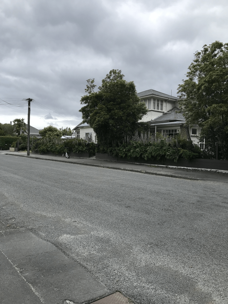
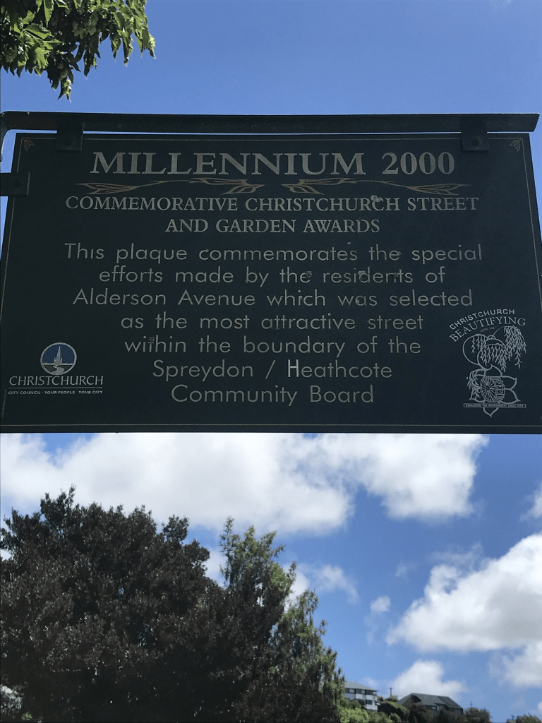
Alderson Ave in Hillsborough – Named after William Stanley Alderson (1890-1974) and his sons, William Stanley Alderson (1915-2004) and Douglas Alderson (1922-1977). The Aldersons managed the Glenmore Products Ltd., brick and tile manufacturers, 1946-1965. First appears in street directories in 1991.
A small amount of information from the library website. Not much information on Papers Past for this family and I spent ages on the Ancestry website trying to get information. The library information for Lucas Lane confused the situation as Joshua Alderson has no connection to William Stanley Alderson’s family. The various family trees on Ancestry were rather confused and not helped by two people named William Stanley Alderson being born in 1890. William had a son called John Dalton Alderson which was the same name as his father which helped sort out the right family. William was born in Hartlepool, Durham and he married Ada Maud Gurney in Australia in 1913. Ada arrived in Australia in 1913 and she was also from Hartlepool. Their children were born in Australia but by 1922 they were living in Wellington but by 1925 they were living in Auckland. In the 1930s and early 1940s they were living in Dunedin. Between 1946 and 1960s they were living in Christchurch before going back to Auckland by about 1968. William’s job involved brickworks in Wellington, Auckland, Dunedin as well as Christchurch. At least one son was involved in the transport industry as a carrier.
Most houses here were built in the 1990s which was when this area was subdivided for housing. The houses built more recently are all rebuilds after the earthquakes. Looked like a pleasant street but footpath was only on one side of the street. The houses were a mixture of styles and a couple stood out for me but not because I liked them. At the top of the street it looks like there used to be a road that went further up the hill. I checked street view from before the earthquakes and the street always stopped here. There is a gate with a sign saying private property and maps say that it is Alderson Reserve.
Lucas Lane in Hillsborough – May be named after Sarah Mabel Alderson, née Lucas, (1884-1966).Sarah Alderson was the wife of Joshua Alderson (1869-1956). The Aldersons managed the Glenmore Products Ltd., brick and tile manufacturers, 1946- 1965. First appears in street directories in 1994.
A small amount of information from the library website and I am not sure that the information is correct. I have spend ages on Papers Past and the Ancestry website and I can find no connection between Joshua Alderson and the Alderson family who managed Glenmore Brick Company. Note this company has various names over the years but they all included the Glenmore name. Joshua Alderson lived his entire life in the Sheffield and Waddington area and his Alderson family possibly came from Lancashire. William Stanley Alderson was born and married in Australia and he lived in Dunedin until the mid 1940s. The Alderson family lived in Christchurch from 1946 to 1966 and then they all went to Auckland.
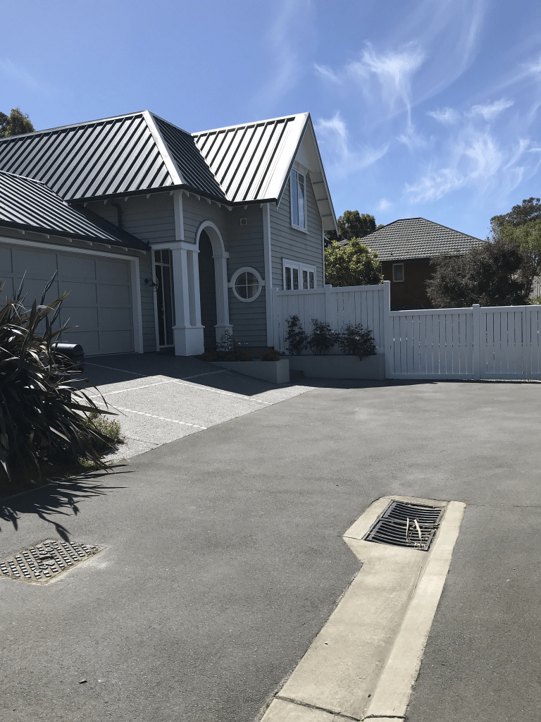
This was another street that I decided not to actually walk on Saturday because it was a private lane. I changed my mind and went back today to walk it. I am so pleased that I did as there is a gorgeous house here and a brand one being built also appealed to me. Only about 13 houses here and 6 were built in the 1990s and rest were rebuilt after the earthquakes. I met two lovely women here and we had a great chat. This is how I know that some of the houses are rebuilds. The gorgeous house I thought had been built by the local builders / developers who have a reputation for building houses that have an old style look about them. I was wrong as the house was designed by the owners of the house. The husband is local but his wife is French and she apparently did most of the designing. The two women that I chatted with said it is a lovely street to live in. They also agreed with me that they wouldn’t like to live on the streets below the reservoir as they wouldn’t feel safe.
Peartree Lane in Hillsborough- Named after a very old pear tree growing in the grounds of Glenmore. Formed post-2000. Information supplied in 2008 by Kevin Blogg in an interview with Margaret Harper.
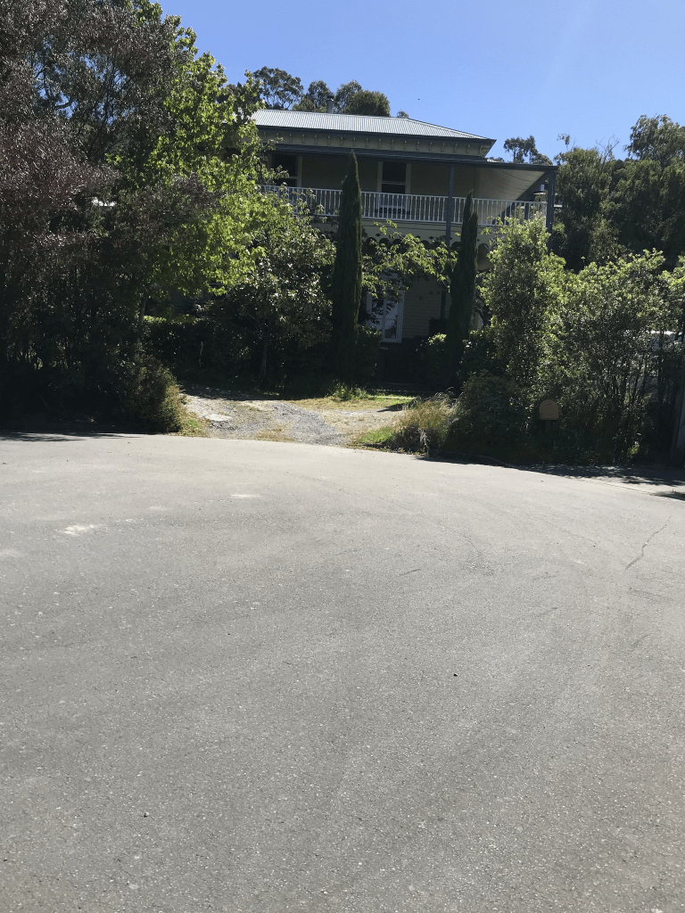
A small amount of information from the library website and I can’t add anything about the name. I was here on Saturday and because it was a private lane without a footpath I decided not to actually walk it. After checking the history of the area I changed my mind and went back to this area today. I am so pleased that I did as there is a house here dating from 1880. I ended up chatting with someone who lives on this street and the 1880s house used to be a homestay but since Covid the owner has a cookery school. The valuation website said that the house dates from 1880 but it is probably older than this and more likely to date from early 1870s.
The book Place Names of Banks Peninsula and the Port Hills by Gordon Ogilvie has a reasonable amount of information about the house and land. John Cordy had a house built here in about 1857 and in 1863 it was sold to Major Henry A Scott. It was Major Scott who named it Glenmore. The property was then sold to J B A Acland of Mt Peel and it was Acland who built the current house. At at least three owners before the Glenmore Brick Company purchased the property in 1901 and the manager of Glenmore Brick and Manufacturing Company lived in the house. The house had been a private nursing home for a few years before the Glenmore Brick Company purchased it. The Alderson family took over the Glenmore Brick Company in the mid 1940s. By 1996 the quarry was closed and the brickworks gone and the house was empty and it was decided to demolish the house to make way for a subdivision on the brickworks site. The house was saved and restored and developed into a quality tourist accommodation.
I took very little notice of the other houses on this street and they date from 1990s to 2000s. It looked like a lovely wee private lane but probably well beyond my budget. The woman that I chatted with said that I sound like a house stalker with my love of older houses. We also chatted about the nearby fire as she was a park ranger for the City Council. It is almost worth enrolling in the cookery school just to get a look inside the house but the concept of me doing a cookery class is just weird.
Stonehaven Tce in Hillsborough – In the Stonehaven subdivision. Named in 2001.
A tiny amount of information on the library website. Stonehaven is a place in Scotland and I am guessing that the street was named after this place especially with a nearby street being also named after a place in Scotland. I know that I have driven past Stonehaven in Scotland but I don’t recall that I had time to stop and explore.
Valuation website said that there are only 5 properties here built between 2010 and 2021. Found an ad that described it as being in the boutique Stonehaven subdivision and boutique usually means expensive. I also found another website that said this street is next to the Rapaki Track. I think whoever wrote that needs to brush up on their geography.
Great views here but the houses didn’t do much for me but we all know that I don’t particularly like modern houses. Going by maps it looks like the street will eventually go all the way to the reservoir. Parking wouldn’t be easy here but that is alright why don’t you just park on the footpath so that pedestrians are forced to walk on the road.
Stronsay Lane in Hillsborough – Named after Stronsay, an island in Orkney, off the north coast of Scotland.In the Stonehaven subdivision. Named in 2001.
A small amount of information from the library website and nothing that I can add about the name except that I would love to go back to the Orkney Islands.
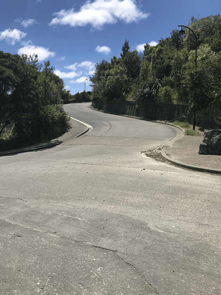
The valuation website said that there are 12 properties here but there are only about 6 houses. Several sections for sale but there is no way that I would buy one of these sections. I managed to find a GNS report plus there is a large reservoir just above the sections. One section had what looks like something that used to be a swimming pool but there wasn’t a house. There is a footpath here but it was blocked by vehicles so I had to walk on the road. Great views. One very interesting looking modern house.
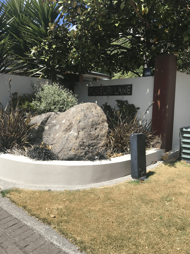
Pukeuri Lane in Hillsborough – First appears in street directories in 1993.
A tiny amount of information from the library website. When I googled Pukeuri it only came up with the town that is near Oamaru. The meaning of the name is probably dark hill.
I only walked a tiny part of this street as I didn’t feel comfortable walking the rest of it. There was a footpath but most of it seemed to be part of the properties here. None of the houses stood out for me and most were built in the 1990s and made from brick. Brick was a very common building material in the 1990s. There were a couple of houses from post earthquakes. Looked like a pleasant street but parking would be a nightmare.