Onepu Street in Bexley Red Zone and nothing on library website. When I checked street view most of the houses looked like they were built in the 1960s but one was an art deco style house. The earliest entry that I could find on Papers Past was an ad for a section in 1960. Sewage works were done in 1962. A few later entries but there weren’t many entries.
I walked this street on Christmas Day and there are no longer any houses here. The street runs off Pages Rd.
Kia Ora Street in Bexley Red Zone and nothing on library website. When I checked street view I realised that this was an older street as there had been a cute cottage that looked that it dated from 1890s. There were also at least two art deco houses. Papers Past had a few death notes and in 1915 there was a B Keats who owned cows. This area was part of the Heathcote Council but in 1916 they were wanting to be a new borough rather than join the city council. They were still arguing about it in 1917. One of the names that came up frequently was E W Simmons and he seemed to object to everything. He frequently wrote letters to the editor and in 1953 in one of his letters he mentioned that he had lived on the street for 42 years. Ernest William Simmons was a poultry farmer on the street. The street got new kerbs and footpaths in 1957 plus there were sewage works in 1962.
I didn’t actually walk this street as I would have needed gumboots and there are no longer any houses here. The street runs off Pages Road.
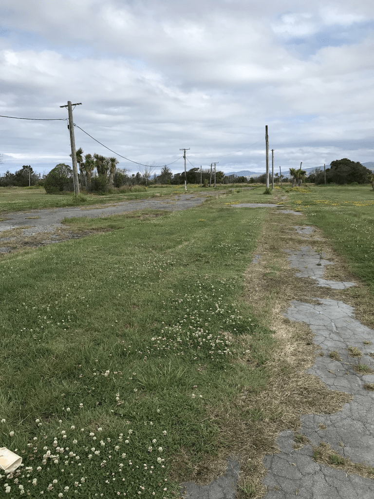
Kokopu Lane in Bexley Red Zone and nothing on library website. The young of Kokopu are what we know as whitebait and they are very delicious. The houses that had been here probably dated from the late 1990s but they have all been demolished. There was an article online from January 2012 about the demolition of the houses. If there hadn’t been a street sign I wouldn’t have known that there had been a street here. The lane ran off a street called Wetlands Grove which should have been a bit of a clue about the land here. My photo includes Wetlands Grove.
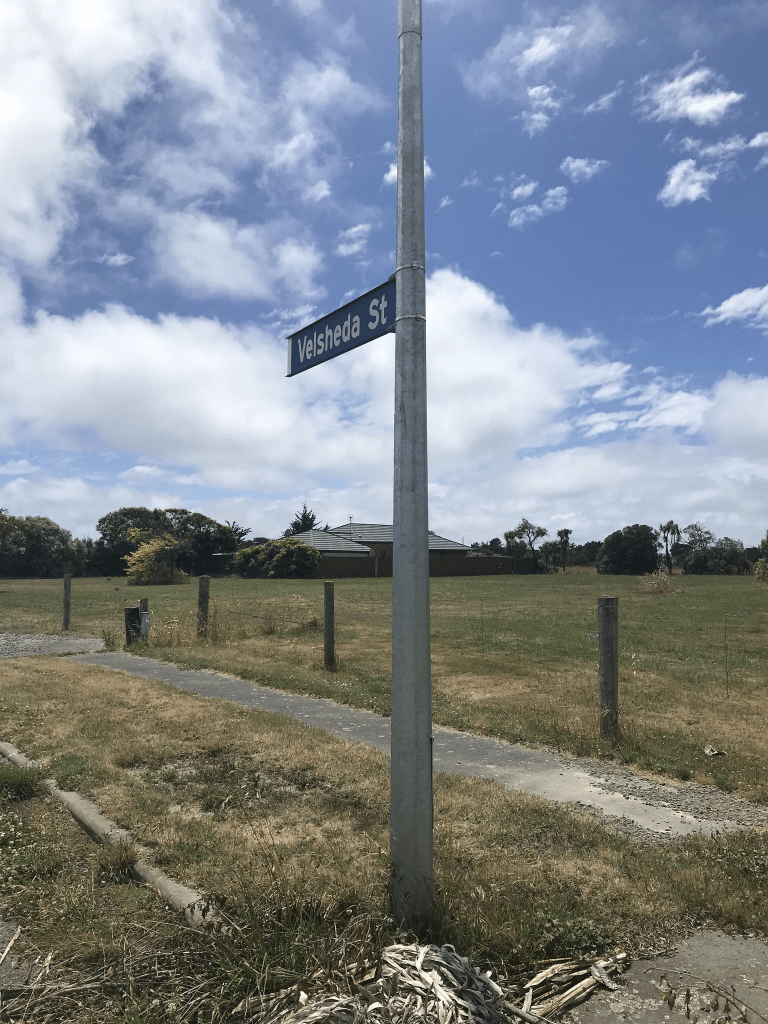
Velsheda Street in the Bexley Red Zone- Named after the Velsheda, a racing yacht. In the Pacific Park subdivision. Named in 1997.
A tiny amount of information from the library website. There is a street called Velsheda Road in a place called Shirley in the UK which confused me briefly. There is a wikipedia page for the yacht and it is named after the designer’s daughters who were Velma, Sheila and Daphne.
I was geocaching in the area today and I was surprised to see that there is still a house on this street. It actually looked like it is in reasonable condition. The rest of the houses have been demolished and after looking at street view for 2007 many of the houses looked quite nice. The houses would have all been built in the late 1990s and there are a couple of articles online about the street after the earthquakes plus a mention in Quake Studies.
York Street – Formerly Balls Road. Named after Robert Ball (1822?-1890).Ball, his wife Jane (1825- 1887) and son Robert (b. 1854?) arrived in Lyttelton on the Mystery in 1859. Ball worked as a blacksmith and later established a coach service and blacksmith’s shop in Balls Road. He ran a coach to Opawa in January 1880, the first American coach imported into Canterbury. Balls Road was developed in 1874 through land formerly owned by Joshua Strange Williams (1837-1915). First mentioned in the Star in 1894 when a property is advertised for sale there. Re-named York Street by 1888. An Edward Ball is listed in street directories as then living in the street. Both street names were used concurrently for a time. Information supplied in 2007 by Gary Dillon of Wanaka, a descendant of Robert Ball, in an interview with Margaret Harper.
A reasonable amount of information from the library website but this information doesn’t match up with early maps. The maps show York St and Balls Road as two separate streets. York St went from the river to Opawa Rd and Ball’s Road sometimes known as Ball’s Lane went from Opawa Rd to Raycroft St. In other words Opawa Rd separated the two streets.
In Papers Past as York St between 1885 and 1890 it was ads for houses and section. From 1910 onwards it was mostly death notices. In the 1880s and1890s Mr Lister of York St was a very busy man as he had a Fruit Garden and Vineries. He also had a Pickle Factory plus a Mineral Water Factory. In 1896 there were obstacles placed in the way of acquiring land to join Upper and Lower York Streets. The council will take the required land under the Land and Public Works Act 1894. This land sounded like it was at the Hassal’s Lane corner. Ball’s Rd possibly was part of York St briefly but it eventually became part of Raycroft St. This was very confusing but Opawa Rd definitely separated the two streets and all the maps from 1912 to 1941 show them as separate streets. The maps for 1950 and 1958 show Ball’s Rd as Raycroft St.
A large number of older houses here dating from 1880 to 1920 and many are in good condition. They had well established gardens and trees and I found it impossible to get photos. A few houses from later decades but many of the older houses are being demolished and several units being built on the sections. Some of the modern units I quite like but the developer here is the only developer who I like. They don’t do toilet block style of housing. Near Hassels Lane there is a big section of land which used to belong to a school and there is possibly a community group here. The school moved to Halswell. I mostly liked this street and I hope that the developer doesn’t ruin it. I have a vague memory of this street from the 1970s and I think that a boy that I went out with briefly lived here. The only reason that I remember is that his surname was York same as the street. He can’t have been that memorable if the only thing that I remember about him is his surname.
Grafton St in Waltham – Formerly William Street. Named after William Barbour Wilson (1819-1897). Re-named Grafton Street. Wilson was a nurseryman, businessman and local politician. In a subdivision of Rural Section 48, land owned by William Wilson (1819-1897). William Street appears on an 1874/75 Deposit Plan. First appears in the Star in an advertisement in 1880. It does not appear in street directories but appears on an 1890 map. Re-named Grafton Street in 1888. Plan of suburban property (Rural Section 48) situated on the Ferry Road near the East Town Belt belonging to William Wilson Esq., Deposit Plan 27 1874/75. Map held by Bob
Pritchard, subdivisions officer, Christchurch City Council. [The land, 200 acres in Ferry Road, had originally been purchased by G. Draper and his son in law, James Edward FitzGerald (1818?-1896).]
A reasonable amount of information from the library website and I am not sure that it being previously named William St is correct. The ad in 1880 actually refers to a street that is where Te Ara is now situated. Other ads say that it is off Lower High Street which again refers to where the William St at Te Ara is situated. I have checked older maps and I can only find the William St at Te Ara. I would have to visit the Archives Office in Wigram to confirm this.
Looking at Papers Past I eventually decided to ignore William St information as it was obvious that none of it related to this street. If anyone has any information showing that this street was originally called William St please let me know. I couldn’t find out how the street got it’s name. In the 1890s there was mostly ads for sections plus one house fire. Between 1900s and 1950s it was mostly birth and death notices. In the early 1900s a Children’s Home was mentioned a few times. They seemed to be an accident prone lot on this street. I was amused by a letter to the editor in 1949 where someone was complaining about there being two streets with the name Grafton. Whoever replied on behalf of the council had a touch of sarcasm in their reply. It was pointed out to the letter writer that Grafton St in Sumner was now Marriner St and had been Marriner St for some time. In 1965 there was a house and land for sale and this property was now zoned industrial.
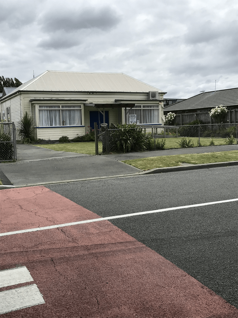
At the dead end of the street it is mostly businesses and the railway line runs behind this end. A huge number of older houses at this end of the street dating from 1905 through to 1920s but sadly many are looking very run down. At least 25% of the houses on this street are dated between 1905 and 1920. The next big lot are from the 1990s and many of these are built from brick. Brick seems to have been the most popular building material in the 1990s and yes I live in a 1990s brick townhouse. There is a house that dates from 1880 and it is now a New Age Christian Centre. There was a block of flats that looked like social housing but couldn’t find out if this was correct. Some of the houses here looked quite nice and well maintained but mostly the street looked very rundown. One of the businesses on the street was a salvage company and another specialised in asbestos. Yes it amused me but then I do have a warped sense of humour. Half way along the street there was a nice playground and I was possibly geocaching here.
Short St in Waltham – Formerly Elizabeth Street. Probably named after Elizabeth Wilson, née Williams (b.1836?). Re-named Short Street. Named because it is a short street leading to Te Wai Pounamu Maori Girls’ College. Elizabeth Wilson was the eldest daughter of John and Isabella Williams and wife of William Barbour Wilson (1819-1897). Wilson was a nurseryman, businessman and local politician who owned Rural Section 48 where this street was formed. Elizabeth Wilson was the first mayoress of Christchurch. Elizabeth Street appears on an 1874/75 Deposit Plan. Re-named Short Street in 1899 by the Linwood Borough Council. Plan of suburban property (Rural Section 48) situated on the Ferry Road near the East Town Belt belonging to William Wilson Esq., Deposit Plan 27 1874/75. Map held by Bob Pritchard, subdivisions officer, Christchurch City Council. [The land, 150 acres in Ferry Road, had originally been purchased by W. Draper, father-in law of J. E. Fitzgerald.]
A reasonable amount of information but there is a mistake about the renaming of the street. The renaming of the street in 1899 is because of duplication of street names as there was also a Elizabeth St in Riccarton. It had nothing to do with the college as the college didn’t open until 1921 and it was built on land belonging to the March family. The original name Elizabeth is probably because of Elizabeth Wilson as many of the streets in the area are named after the members of the Wilson family.
There were thousands of entries for Elizabeth St as it was a popular name for streets. I ended up using Linwood and Opawa when researching so I have possibly missed some information. When the street was Elizabeth St is was mostly birth and death notices plus the information in 1898 and 1899 about the street name being changed because of duplication. In the 1910s and 1920s there were several birth notices mentioning Nurse Barson’s Nursing Home. Her name was also mentioned in an inquest where a young woman had died. The young woman died at Christchurch hospital but had been recovering from an operation at Mrs Barson’s Nursing Home. I suspect that the young woman had had an abortion going by the description of the operation by the doctors concerned. In 1915 a Mr M A Elam of New Brighton was subdividing land in this street. By 1950s there was a business on this street called Industrial Metals Ltd and the street has been a mixture of housing and business ever since.
The oldest house on the street is from 1915 and there is a big empty section where houses have obviously been demolished fairly recently. I checked street view on google maps and one of the demolished houses looked like a lovely well maintained 1920s villa. The other demolished house was also from 1920s but wasn’t in the best of condition. Not many houses here and at the end of the street there are a couple of businesses.
Henry St in Waltham – Named after Henry Wilson. Wilson was the fourth son of William Barbour Wilson (1819-1897), nurseryman, businessman and local politician, and his wife, Elizabeth. He married Charlotte Cox of Featherston. He was in the hardware trade in Christchurch for a number of years and died in England. In a subdivision of Rural Section 48, land owned by William Wilson (1819-1897). Henry Street appears on an 1874/75 Deposit Plan. First appears in street directories in 1913. Plan of suburban property (Rural Section 48) situated on the Ferry Road near the East Town Belt belonging to William Wilson Esq., Deposit Plan 27 1874/75. Map held by Bob Pritchard, subdivisions officer, Christchurch City Council. [The land, 200 acres in Ferry Road, had originally been purchased by G. Draper and his son in law, James Edward FitzGerald (1818?-1896).]
A reasonable amount of information from the library website. I didn’t manage to get much information from Papers Past as there was a huge number of streets with the name Henry Street. A few entries using Opawa and Linwood but nothing using Waltham. A few death notices and recruitment notices. From 1950s onwards all the entries were for a business called Lomak Furniture including a big fire in 1974. It was also impossible to find any information about Henry Wilson on Papers Past thanks to a Sir Henry Wilson being assassinated. The ancestry website was of no help at all. All the family trees for this man had his father as William Balfour Wilson and family trees for William Barbour Wilson have a totally different family. I did find a grave for Henry Ernest Wilson in England.
This tiny street only has businesses in it and I didn’t take any photos
Hornbrook Street in Waltham- formerly Hornbrook Lane. Named after Major Alfred Hornbrook (1814- 1898) and his wife, Sarah Frances Anne Hornbrook, née Hewit, (1830?- 1913). Hornbrook owned Risingholme and Mrs Hornbrook ran a boarding-school at the corner of Wilsons Road and this street. Hornbrook Street is first mentioned in The Press in 1886. It is listed as Hornbrook Lane in street directories from 1892. Becomes Hornbrook Street in 1930.
A small amount of information from the library website. I couldn’t find any entries on Papers Past under the name Hornbrook Lane. There is a Hornbrook St in Temuka as Major Hornbrook’s younger brother William Hornbrook went to live in the Temuka area to manage Major Hornbrook’s properties in that area. The earliest entry that I found on Papers Past was in 1885 where residents complained about the state of the street. The Road Board’s reply was the street had never been dedicated or taken over by the Road Board so they wouldn’t be spending any money on it. In 1886 the ratepayers asked the Road Board if they will put put a bridge over the creek if they form the road. In 1889 they were still talking about forming the road. In 1891 there was a cottage and land for sale and a horse and cart was included in the sale. Another ad said that the property had been especially adapted for a carrier or cabman. Major Hornbrook in 1871 was selling his property as he was planning on moving to Timaru. Major Hornbrook was selling all his properties including the Mt Pleasant one and the Temuka ones. He went bankrupt in 1871 and he also managed to go bankrupt again in 1879. The website for Risingholme states that William Reeves owned Risingholme so I assumed that he has purchased it from Major Hornbrook but this was incorrect. I found an entry for William Reeves living at Risingholme as early as 1866. Mystery solved by an entry in 1890 where there were two houses for sale at Risingholme. One belonged to William Reeves and the other belonged to Mrs Hornbrook. I suspect that Major Hornbrook actually put this property into his wife’s name when he went bankrupt in 1871. Both houses were on land that was 11 acres in size for each property. The ad also called it Wilson’s Bridge Rd. By this time Major Hornbrook had disappeared to Queensland to live with his son and he died there in 1898. Note his wife stayed in Christchurch and she was still living on Wilsons Rd in 1903 as she was fined for attempting to poison dogs. She was living in Lyttelton when she died in 1913.
The houses here date from 1910 to 2022 and I was disappointed that the older houses had been altered so that they no longer looked like interesting older houses. The two houses that stood out for me were from 1930 and 1950. The one from 1950s looked older and was fairly large. It had been divided into flats. There is a green space near Wilsons Rd end of the street.
Ferry Road – formerly Sumner Road, Ashbourne Road and Regent Street. Formerly Sumner Road. Named after John Bird Sumner (1780-1862). Re-named Ferry Road. Named because it was the road leading to the ferry at the Heathcote River. From St Asaph Street to the East Belt (later Fitzgerald Avenue) was formerly Sumner Road. Sumner was an Archbishop of Canterbury and a President of the Canterbury Association. Formation of the road began in 1850 and was improved at time of establishment of Provincial Government. A ferry service was established connecting the Ferry Road with the Heathcote Valley Road leading to the foot of the Bridle Path.”Heathcote Ferry Road” is first mentioned in the Lyttelton Times in 1851. In 1884 “the Ferry Road, from Hargood’s Road to the swing bridge” was re-named Regent Street. From Ensors Road-Aldwins Road to Radley Street was re-named Ashbourne Street in 1893 and became part of Ferry Road in 1922. From Radley Street to the Heathcote bridge remained as Regent Street until 1922 when it was re-named Ferry Road. [The ferry went out of business when the bridge was built over the Heathcote River.]
A reasonable of information from the library website. There was a huge amount of information on Papers Past and trying to get information from when it was called Sumner Rd was almost impossible. There was a Sumner Rd in Lyttelton and a Sumner Rd in Sumner. So many articles and letters to the editor were about the Sumner Rd in Sumner and some people wanting a tunnel through Evans Pass. The best information about the Sumner Rd that became Ferry Rd was from ads in the 1850s. J F Smart had a private boarding house called Caversham House and this was on the corner of Sumner RD and Madras St at the entrance of Christchurch. He also had stables on the premises. He was a busy man as he also carted goods from the Quay for people plus did firewood. The White Hart Inn owned by M B Hart was opened in 1852. The same year Robert Watson moved his business from Cashel St to Sumner Rd next to the White Hart Inn. In 1953 the site for the proposed Town Hall had three frontages of Hereford St, Cathedral Square and facing down Sumner Rd. In 1854 W Wilson had two sections available on Sumner Rd and these were opposite the Wesleyan Chapel with frontages on Sumner Rd, Cashel St, Hereford St and Colombo St. W Wilson had a lot of land in this area and he was a nasty man.
Ashbourne St seemed to be a couple of dairy farms plus lots of ads for people selling potatoes, tomatoes, chickens and apples. W A Rainsford had a grocery shop. The Woolston Methodist Church was mentioned and this was on Aldwins Rd corner.
Regent St and this street had lots of death notices. A few places and people mentioned were the Woolston and Opawa Money Club, Loyal Perseverance Lodge Rooms, Wharf Hotel, Mr Hopkins shop, R Coupland a grocer and Soloman Richard Charlesworth. There was a fire in a block of shops in 1919. There was a big problem with cyclists on the footpath including Samuel Hurst Seagar. Cyclists were fined for this and yes I would love for cyclists these days to be fined for being on the footpath. This road also saw a motorbike plus a horse and cart on the footpath. There was an article in 1919 where the residents didn’t want the street name to go back to Ferry Rd and would prefer to keep the aristocratic name of Regent St. There was an article in July 1919 that said the streets known as Lower High St, Ferry Rd, Ashbourne St and Regent St will be renamed Ferry Rd.
Huge number of entries as Ferry Rd including lots of death notices. There was an article in 1910 about trotting in Canterbury and the first trotting race on a racecourse in Canterbury was held on a location called Brown’s Paddock on Ferry Rd about 1875/1876. In 1880s a club was formed called Lower Heathcote Racing Club and these races were held opposite to Brown’s Paddock.
In 1916 there was a collision between a night soil cart and a tram. The horses had been left unattended and had crossed the road. The horses had to be destroyed. No mention of the mess that a night soil cart would have made. In 1920 it was decided that Ferry Rd from High St to Aldwins Rd was to be known as Ferry Rd City and Ferry Rd from Aldwins Rd to Heathcote Bridge to be known as Ferry Rd Woolston. This was because of the confusion caused by the duplication of street numbers.
In 1925 Monica Park was officially opened and the stands could hold 1000 people and it had two playing fields. This was for rugby league games. Residents in 1924 wanted Ferry Rd in Woolston to be brought up to the same standard as Ferry Rd in the city. St Peter’s Church that was on the corner of Aldwins Rd and Ferry Rd was mentioned a few times. In 1931 there was a meeting of ex-pupils as Woolston School had ben in existence for 66 years. I shouldn’t been amused by a shop that had been burgled a few times plus held up once in the 1930s but the shop’s name was Self Help Store.
In 1944 you could get your meat ration coupons from the Post Office here. In 1947 the council approved the sale of a block of land for the erection of a picture theatre. A couple of fires in the 1940s and one was at the Oddfellows Hall and the other was at the factory of Provita Mills Ltd. In an obituary in 1941 it was mentioned that sod huts were very common on Ferry Rd for the early settlers to live in.
In 1950 they hadn’t yet acquired the land for the Tunnel Rd that will be going from Ferry Rd to Lyttelton. In 1957 Ballin Brothers Ltd wanted to transfer the license for the Saxon Hotel in Lyttelton to a site at 408 Ferry Rd where they planned to build a new hotel. Their reason was that the Saxon Hotel had been condemned. In 1958 the licensing board refused this application. I am sure that I remember the Saxon Hotel in Lyttelton and I was born in the 1950s.
In 1960 Dr Newman a widow had a medical practice on Ferry Rd and she was found murdered. In 1962 it was the 50 year jubilee for G L Bowron and this company started out in St Johns St. They then built a factory on Ferry Rd but when this building burnt down they moved to the site near Woolston Station. In 1969 the new Roman Catholic Church of St Anne’s was opened. In the 1970s and 1980s some of the places mentioned were the Early Settlers Hall, Koinonia Christian School, Woolston Park Pool, Vistalite Aluminium and Portstone Restaurant. A big fuss made when A and T Burt Mechanical Ltd decided to close it’s factory.
Te Waipounamu Maori Girls College was mentioned a few times and I remember this school as I had a friend who lived next door to it.
I walked this street a couple of weeks ago and I had taken a bus to Sumner and walked home to Addington. From Ferrymead Bridge to the Tunnel Rd roundabout it is mostly businesses with a few houses near the Tunnel Rd roundabout. I did pop into the ANZ to say hello but it getting to the stage where I hardly know anyone in the bank now. After the Tunnel Rd roundabout it is mostly houses plus St Anne’s Church. Then you come to the Woolston Shopping centre but I didn’t stop to shop. Several secondhand shops and I think that there was a supermarket here. More houses and near the river there are motels. A mixture of houses and businesses on one side and Woolston Park and Woolston School on the other side. The War Memorial is fenced in because of it being vandalised numerous times. There is a new lodge here which would be a rebuild and I am not sure if they are still Oddfellows Lodge. The school has been totally rebuilt from when I attended the school. Then it is more businesses with the occasional house in between. The petrol station is now a self serve one and I remember that there was a big block of shops here. There is an Animal and Bird Hospital and before long you are at Aldwins Rd corner where I closed my eyes when walking. Just joking but I did manage to restrain myself and not visit the bookshops here. Cross the road and there is the Edmonds Factory Garden. Does anyone remember the impressive building that was the Edmonds Factory. On the opposite side of the road is the motels which recently had an arson attack. Then there is Te Wai Pounamu Maori Cultural Centre and this is where there was a Maori Girls College. I had a school friend who lived next door and the college which was a boarding school was a big two story building. I continued walking and it was mostly businesses with the occasional house. At this point you reach Moorhouse Ave and you go to the right to continue down Ferry Rd and it is businesses here but near the end of the street there is the Catholic Cathedral College and Ara Institute. These two educational places occupy at least two blocks. I have probably missed a few places but it is a very long street to walk with a huge variety of buildings. The houses here date from every decade starting at 1880 until 2021. A surprising number of houses date from 1915 and then a big lot from the 1930s and 1970s.