Port Hills Road in the suburbs of Heathcote Valley and Hillsborough, Christchurch

Port Hills Rd in Heathcote Valley and Hillsborough – formerly Hills Rd. Port Hills Road follows the lower slopes of Murray Aynsley and was once used to avoid ferry fees. Hills Road, Opawa, was renamed the Port Hills Road by the Heathcote Road Board in 1909. Port Hills Road first appears in street directories in 1914.

A small amount of information from the library website. I ended up having a good look at old maps for this street and it isn’t as simple as the explanation on the library website. The map for 1922 has Hills Rd going from Heathcote Valley to either Vernon Tce or Albert Tce and then it is Port Hills Rd to Dyers Pass Rd. The map for 1929 is similar except for an extra road at the bottom of Huntsbury Ave. That map seriously confused me. The map for 1930 has Hills Rd from Heathcote Valley to St Martins Rd and the bit that was called Port Hills Rd is now called St Martins Rd and this goes to Dyers Pass Rd. There is still an extra road at Huntsbury but it has moved up the hill a bit. This extra road doesn’t match up with an current existing roads. The map for 1941 has Port Hills Rd running from Opawa Rd to Heathcote Valley and Hills Rd is running from Opawa Rd to a road called Victoria Tce which seems to be where Albert Tce is. The map for 1950 has Port Hills Rd exactly the same as modern maps. I hope that you are all now as confused as me. Have a look at the maps on the library website as they are fun to look at especially for someone like me who loves maps.

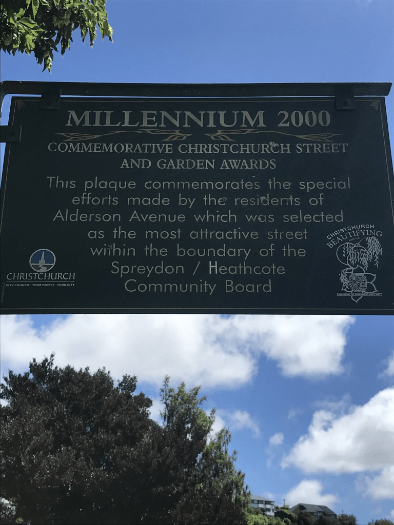
There were a huge amount of entries on Papers Past and this wasn’t helped by there being several Hills Roads in the Christchurch and Canterbury area. I decided to search using Port Hills Heathcote and then Hills Rd Heathcote. Under Port Hills Heathcote there was mostly death notices in Papers Past. A Mrs Favell lived on this street and there is a Flavell St in Heathcote. In 1936 the AA wanted the dangerous corner at the corner of Bridle Path Rd and Port Hills Rd to be improved. The reply to the AA was that the majority of drivers had no problems with this corner. In 1961 the council was looking for the history of an old homestead that was possibly about 100 years old. The house and land had been given to the council several years earlier and it was part of Mary Duncan estate. The house had been neglected but the council were hoping that the historic society would take it over. I suspect that this house is long gone and there is a Duncan Reserve off Port Hills Rd. Mr F C Garland’s poultry farm is frequently mentioned especially in ads. That explains Garlands Rd. In 1973 a company called D F Nuttall Steel Ltd was mentioned and this explains another street in the area. The Canterbury Malting Company had a few mentions and I remember this building in Heathcote Valley. In 1978 a telephone box on the corner of Port Hills Rd and Curries Rd was destroyed by an explosion on Guy Fawkes Night and a youth was arrested. Shows that we have always had idiots.

In January 1972 passenger trains between Lyttelton and Christchurch were to stop. They would be replaced by a bus service that would go to Christchurch via Port Hills Rd and Opawa Rd. This was a big thing for Lyttelton as we travelled by train to Christchurch to go to High School. My last year at High School was in 1971 so I never had to travel by bus to High School. Students in Lyttelton were given free transport to Christchurch to go to school after the High School in Lyttelton was closed. I am now going to have to find out the date of when the High School in Lyttelton closed. The bus from Lyttelton used to go down Ferry Rd as I used to catch this bus when I went to Woolston Primary school in 1968. My Nana used to catch the bus from Lyttelton to Woolston and then walk to the various cemeteries that are near Linwood Ave. I honestly can’t remember if there were two bus routes for a while after the passenger trains stopped. I just know that she walked from Ferry Rd to the cemeteries and after they stopped the Ferry Rd route she used to walk from Opawa Rd. Note she was in her 70s and 80s when she was doing this. Get the feeling that my walking ability is genetic.

Under Port Hills Rd, Opawa it was mostly just ads for Glenmore Bricks Ltd. In 1976 Isaac Construction Ltd subdivided an old clay quarry opposite the Coca Cola plant into 22 sections. I did find a death notice for 1867.

Many entries in the 1870s and 1880s seem to be about the condition of the road or drainage issues. There was a water course that crossed Hills Rd which frequently caused problems after heavy rain. I got the impression that this water course was near the railway line but I couldn’t figure out exactly where it was. In 1872 the Valley residents requested that they be allowed to use the swing bridge free of tolls until Hills Rd is passable again. I think that I am going to have to visit the library or archives to find out exactly where this swing bridge was. Edited to say that the swing bridge was the Ferry Road Bridge.

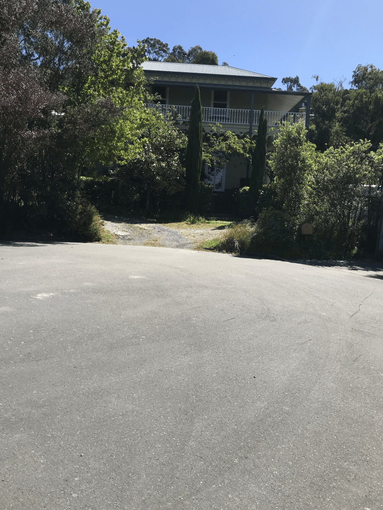
I also had a memory of going to functions at a building on this street. Found several entries for The Old Orchard and these were mostly in the 1970s and 1980s. I don’t know when it stopped holding functions but it was sold to an Australian company in 1988. I checked street view and the building was still there before the earthquakes but didn’t seem to be a function centre any longer. I couldn’t find out any information about the original orchard but there were lots of orchards in this area.

I actually walked most of this street in January 2020 and got a bit of a shock when I checked the dates on my photos as I hadn’t realised it was so long ago. I had caught a bus to Heathcote and then walked home to Addington. When I checked maps I realised that the road did a sharp turn at Opawa Rd and continued to Centaurus Rd. Finally walked the final bit this week.

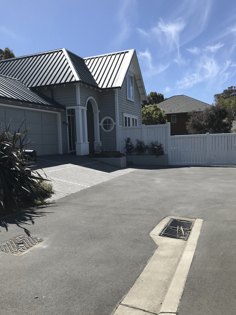
The street starts at the Bridle Path Rd and the Heathcote Domain is one side and houses are on the other side. The houses here date from 1880 to 1920 and there are at least 30 older houses and many are still looking good. I took a photo of a rundown older house when I walked here in 2020 and I expected it to have been demolished. I was surprised to find that it had been done up and as looking good so I took a screenshot from google maps.. My niece lived on this street at one stage but don’t ask me to remember the dates. If I have the figured out the correct house she possibly lived in a house that was built in 1915.

Where the Canterbury Malting Company used to be there are now about 60 units and they are called Maltwork Villas. The factory was still there in 2018 but by 2019 it was a big empty section and the units were built in 2020. The villas are aimed at older people. There is then a few shops including a cafe. In 2020 I ended up talking to Flo from Lyttelton and she will be sadly missed in Lyttelton. As I continue walking the older houses are still on the hill side of the street while newer houses are on the flat side. I eventually walked under the overbridge of the Tunnel Road. This part of the road has businesses on one side until you get to Opawa Rd. On the other there is Duncan Reserve and then a few houses. These houses are mostly from the 1970s. On the same side of the houses and getting closer to Opawa Rd there is a big block of storage units. A few houses and then it is Opawa Rd. At Opawa Rd it is a sharp turn left and the road continues to the top of the hill. This road has always done a sharp turn here. This road going by old map used to continue but it is now part of Centaurus Rd. The houses here are mostly from the 1990s as this is where the Brickworks and the quarry used to be. A few gaps where demolished houses haven’t been rebuilt. I walked as far as the giraffe as every time I drive past I say to myself that I must get a photo. The giraffe is actually at a Centaurus Rd address. When I walked this part of Port Hills Rd this week I was able to observe the helicopters and the monsoon buckets. The monsoon buckets were smaller than I expected.

Alderson Avenue in the suburb of Hillsborough, Christchurch

Alderson Ave in Hillsborough – Named after William Stanley Alderson (1890-1974) and his sons, William Stanley Alderson (1915-2004) and Douglas Alderson (1922-1977). The Aldersons managed the Glenmore Products Ltd., brick and tile manufacturers, 1946-1965. First appears in street directories in 1991.

A small amount of information from the library website. Not much information on Papers Past for this family and I spent ages on the Ancestry website trying to get information. The library information for Lucas Lane confused the situation as Joshua Alderson has no connection to William Stanley Alderson’s family. The various family trees on Ancestry were rather confused and not helped by two people named William Stanley Alderson being born in 1890. William had a son called John Dalton Alderson which was the same name as his father which helped sort out the right family. William was born in Hartlepool, Durham and he married Ada Maud Gurney in Australia in 1913. Ada arrived in Australia in 1913 and she was also from Hartlepool. Their children were born in Australia but by 1922 they were living in Wellington but by 1925 they were living in Auckland. In the 1930s and early 1940s they were living in Dunedin. Between 1946 and 1960s they were living in Christchurch before going back to Auckland by about 1968. William’s job involved brickworks in Wellington, Auckland, Dunedin as well as Christchurch. At least one son was involved in the transport industry as a carrier.

Most houses here were built in the 1990s which was when this area was subdivided for housing. The houses built more recently are all rebuilds after the earthquakes. Looked like a pleasant street but footpath was only on one side of the street. The houses were a mixture of styles and a couple stood out for me but not because I liked them. At the top of the street it looks like there used to be a road that went further up the hill. I checked street view from before the earthquakes and the street always stopped here. There is a gate with a sign saying private property and maps say that it is Alderson Reserve.

Lucas Lane in the suburb of Hillsborough, Christchurch

Lucas Lane in Hillsborough – May be named after Sarah Mabel Alderson, née Lucas, (1884-1966).Sarah Alderson was the wife of Joshua Alderson (1869-1956). The Aldersons managed the Glenmore Products Ltd., brick and tile manufacturers, 1946- 1965. First appears in street directories in 1994.

A small amount of information from the library website and I am not sure that the information is correct. I have spend ages on Papers Past and the Ancestry website and I can find no connection between Joshua Alderson and the Alderson family who managed Glenmore Brick Company. Note this company has various names over the years but they all included the Glenmore name. Joshua Alderson lived his entire life in the Sheffield and Waddington area and his Alderson family possibly came from Lancashire. William Stanley Alderson was born and married in Australia and he lived in Dunedin until the mid 1940s. The Alderson family lived in Christchurch from 1946 to 1966 and then they all went to Auckland.

This was another street that I decided not to actually walk on Saturday because it was a private lane. I changed my mind and went back today to walk it. I am so pleased that I did as there is a gorgeous house here and a brand one being built also appealed to me. Only about 13 houses here and 6 were built in the 1990s and rest were rebuilt after the earthquakes. I met two lovely women here and we had a great chat. This is how I know that some of the houses are rebuilds. The gorgeous house I thought had been built by the local builders / developers who have a reputation for building houses that have an old style look about them. I was wrong as the house was designed by the owners of the house. The husband is local but his wife is French and she apparently did most of the designing. The two women that I chatted with said it is a lovely street to live in. They also agreed with me that they wouldn’t like to live on the streets below the reservoir as they wouldn’t feel safe.

Peartree Lane in the suburb of Hillsborough, Christchurch

Peartree Lane in Hillsborough- Named after a very old pear tree growing in the grounds of Glenmore. Formed post-2000. Information supplied in 2008 by Kevin Blogg in an interview with Margaret Harper.

A small amount of information from the library website and I can’t add anything about the name. I was here on Saturday and because it was a private lane without a footpath I decided not to actually walk it. After checking the history of the area I changed my mind and went back to this area today. I am so pleased that I did as there is a house here dating from 1880. I ended up chatting with someone who lives on this street and the 1880s house used to be a homestay but since Covid the owner has a cookery school. The valuation website said that the house dates from 1880 but it is probably older than this and more likely to date from early 1870s.

The book Place Names of Banks Peninsula and the Port Hills by Gordon Ogilvie has a reasonable amount of information about the house and land. John Cordy had a house built here in about 1857 and in 1863 it was sold to Major Henry A Scott. It was Major Scott who named it Glenmore. The property was then sold to J B A Acland of Mt Peel and it was Acland who built the current house. At at least three owners before the Glenmore Brick Company purchased the property in 1901 and the manager of Glenmore Brick and Manufacturing Company lived in the house. The house had been a private nursing home for a few years before the Glenmore Brick Company purchased it. The Alderson family took over the Glenmore Brick Company in the mid 1940s. By 1996 the quarry was closed and the brickworks gone and the house was empty and it was decided to demolish the house to make way for a subdivision on the brickworks site. The house was saved and restored and developed into a quality tourist accommodation.

I took very little notice of the other houses on this street and they date from 1990s to 2000s. It looked like a lovely wee private lane but probably well beyond my budget. The woman that I chatted with said that I sound like a house stalker with my love of older houses. We also chatted about the nearby fire as she was a park ranger for the City Council. It is almost worth enrolling in the cookery school just to get a look inside the house but the concept of me doing a cookery class is just weird.

Stonehaven Terrace in the suburb of Hillsborough, Christchurch

Stonehaven Tce in Hillsborough – In the Stonehaven subdivision. Named in 2001.

A tiny amount of information on the library website. Stonehaven is a place in Scotland and I am guessing that the street was named after this place especially with a nearby street being also named after a place in Scotland. I know that I have driven past Stonehaven in Scotland but I don’t recall that I had time to stop and explore.

Valuation website said that there are only 5 properties here built between 2010 and 2021. Found an ad that described it as being in the boutique Stonehaven subdivision and boutique usually means expensive. I also found another website that said this street is next to the Rapaki Track. I think whoever wrote that needs to brush up on their geography.

Great views here but the houses didn’t do much for me but we all know that I don’t particularly like modern houses. Going by maps it looks like the street will eventually go all the way to the reservoir. Parking wouldn’t be easy here but that is alright why don’t you just park on the footpath so that pedestrians are forced to walk on the road.

Stronsay Lane in the suburb of Hillsborough, Christchurch

Stronsay Lane in Hillsborough – Named after Stronsay, an island in Orkney, off the north coast of Scotland.In the Stonehaven subdivision. Named in 2001.

A small amount of information from the library website and nothing that I can add about the name except that I would love to go back to the Orkney Islands.

The valuation website said that there are 12 properties here but there are only about 6 houses. Several sections for sale but there is no way that I would buy one of these sections. I managed to find a GNS report plus there is a large reservoir just above the sections. One section had what looks like something that used to be a swimming pool but there wasn’t a house. There is a footpath here but it was blocked by vehicles so I had to walk on the road. Great views. One very interesting looking modern house.

Pukeuri Lane in the suburb of Hillsborough, Christchurch

Pukeuri Lane in Hillsborough – First appears in street directories in 1993.

A tiny amount of information from the library website. When I googled Pukeuri it only came up with the town that is near Oamaru. The meaning of the name is probably dark hill.

I only walked a tiny part of this street as I didn’t feel comfortable walking the rest of it. There was a footpath but most of it seemed to be part of the properties here. None of the houses stood out for me and most were built in the 1990s and made from brick. Brick was a very common building material in the 1990s. There were a couple of houses from post earthquakes. Looked like a pleasant street but parking would be a nightmare.

Reservoir Lane in the suburb of Hillsborough, Christchurch

Reservoir Lane in Hillsborough – Named because it is next to a Christchurch City Council reservoir. Named in 2006

A tiny amount of information from the library website and the developer needs to get his eyes tested as it isn’t next to the reservoir. The reservoir isn’t too far away but the reservoir is actually at the end of Stonehaven Terrace.

Valuation website said that there are 6 properties here but at this stage there are only 2 houses that have been built. The houses are huge. Great views but I wouldn’t like to live here. Google maps show a sign saying Reservoir Lane but yesterday there was only one sign saying private lane. There is another sign that says residents and delivery vehicles only. The footpath was only on one side of the narrow street.

Main Road in the suburbs of Redcliffs, Clifton, Mt Pleasant and Moncks Bay, Christchurch

Main Road in Redcliffs, Clifton, Mt Pleasant and Moncks Bay – A continuation of Ferry Road after Ferrymead Bridge through to Sumner. First appears in street directories in 1910.

A tiny amount of information from the library website. I ended up looking at several older maps for this street. In earlier maps the road from the Ferry Road Bridge to The Causeway was called Christchurch and Sumner Road. The Main Road was mostly just in Redcliffs and from Redcliffs to Sumner much of it was called the Sumner Causeway. When looking at Papers Past most entries for Main Road were ads and death notices. Starting at the Sumner end there is Peacock’s Gallop and this was mentioned as early as 1886 when there was a slip on the road known as Peacock’s Gallop and the workmen soon cleared the obstruction. In 1905 the Hon J T Peacock said to the Tramway Board that he was in favour of widening the road the went under the Sumner cliffs. He then stated that he used to gallop along that part of the road in order to get over it as fast as possible and that it used to be known as Peacock’s Gallop. This was in reply to the Tramway Board who said that some 7 million passengers had been carried on the trams over Peacock’s Gallop during the last 16 to 17 years and that there had only been one disruption due to falling rocks. In 1915 the construction of the Sumner Causeway was started and this causeway was for trams to run from Shag Rock corner to the viaduct. In 1916 the new Sumner Causeway was opened and this ran between Shag Rock corner and the Tram Bridge and this removed the headland danger. The viaduct and Tram Bridge would have been other names for the McCormacks Bay Causeway. In 1928 there was opposition to the forming of a road next to the tramway at the front of the Sumner cliffs. There was very little mention of the part of the road that went from The Causeway to Ferry Rd. Redcliffs School was opened in1907. The Redcliffs Methodist Church was opened in 1926 and the new Presbyterian Church was opened in 1927. St Andrews Mission Church was also mentioned. The library was mentioned as early as the 1920s. Several sections were available in 1913. In 1959 there were moa hunter traces found in the garden of a house. This road seemed to have a lot of accidents especially ones where cars ended up in the estuary.

The houses here cover every decade from 1905 to 2023 with most built in 1970s and 1980s. Too many styles to describe ranging from boring to fairly quirky.

I took the bus to Sumner so that I could walk this road. The road starts by the Sumner Surf Life Saving Club and there is a walkway that I could follow. There is the estuary on one side and a cliff face on the other side. The cliff face is where Peacock’s Gallop was and I remember when there was a nice grassy reserve here. This would have been where the original trams used to run. It is now covered with rocks from the cliffs which fell during the earthquakes. Then you come to the Christchurch Yacht Club by the estuary side with a few houses on the other side. From the yacht club onwards it is mostly houses until you come to the shops. On the other side there were houses plus Barnett Park. The supermarket is now closed. I managed to resist popping into the library where they were having a book sale. A few more shops before there are more houses. On the other side there were a few houses including a big house that is called Brigadoon. It used to have the most wonderful garden decorations but they are no longer there. There is a large empty section where the school used to be. The school is now on the other side of the road. Just before you get to the Moa Cave there used to be a bright yellow house but it was destroyed in the earthquakes. The original owner of this house used to hold charity functions in the cave on his property and he was kind enough to show a group of us around the cave. I then walked across the Causeway to rejoin the Main Road. From this part of the road the estuary is on one side with a mixture of cliffs and houses on the other side. It is then Scott Park and the Mt Pleasant Yacht Club just before you reach the Ferry Road Bridge. The cob cottage now has a permanent cover over it and the cottage looks very sad. I found an article from 2018 that said that the cottage will be repaired. This obviously hasn’t happened and it looks worse now than what it did after the earthquakes. One interesting item that I came across when reading Papers Past was that a local group wanted a causeway to be built from Shag Rock to the Southshore Spit. This obviously didn’t happen.

When I was at High School I used to occasionally stay with a friend who lived on this road. The house that she lived in was originally a shop before it became a private house. After the earthquakes it was eventually demolished and a new house built. When I was a teenager I also knew a few other teenagers who lived on this road.

The Causeway in the suburb of Redcliffs, Christchurch

The Causeway in Redcliffs – In the 1880s, tramway companies put tram tracks across the waters at the entrance to McCormacks Bay. In the Depression of the 1930s, one of the major public works programmes was to fill in the area under the tracks and put a roadway on top

A small amount of information from the library website. This is the short stretch of road that goes across McCormacks Bay and I have always known it as The Causeway. Google maps have it as Main Road yet I have found articles as late as 2011 calling it The Causeway. I do have an AA map of Christchurch which calls it Main Road but I remember getting this map in about 2019 to help me with my street project. My original idea for my street project was to walk a street and then highlight it on the map but I obviously decided to do my street project a bit differently.

The tramway was extended to Sumner in 1888 and until that date it finished at the Heathcote Bridge. There were two parts of the tramway that were called causeways but I am only talking about the McCormacks Bay tram causeway. Not much information on Papers Past about the tramway but I do have to mention a drowning here that happened in April 1906 as the man was my great, great grandmother’s second husband.

Lots of articles in the 1930s as this is when they widened the causeway so that it could take cars. The first step was to extend the old spur that jutted out from the current road to join the causeway. They also had to get permission from the Lyttelton Harbour Board for the construction. Part of the existing tramway causeway was over bridges and McCormacks Bay had at least two outlets to the estuary. There was work for 300 men to help construct the road alongside the tramway on the seaward sea of the causeway. Note the men employed were relief workers and relief workers were unemployed men who were paid to do this work. From some of the articles that I have read it sounds like they were paid less than normal workers. There were several photos in Papers Past and they were interesting. There were two groups opposed to this road being formed. One group opposed the cost of the project. The second group were wanting to build Christchurch Port at McCormacks Bay and the Causeway was blocking access to the bay. Obviously Christchurch never got a port. The tramway Company had a quarry at McCormacks Bay and this is where they got the material to build the road. Before this road you had to drive around McCormacks Bay and in 1913 a car managed to miss the turn off and drove onto the tramlines. It was foggy conditions. Over the years several cars have managed to drive off the Causeway and into the estuary. Speed was usually the problem. In 1920 a moa bone that had been found here when the tramway was built was gifted to the museum.

In 1978 the Causeway was widened plus they added a footpath. A cycleway was considered unnecessary. It obviously now has a cycleway as it is part of the Coastal Pathway Project.

Yesterday when I walked here I ended up walking with another person and we had a great chat. She was amazed that I had caught a bus to Sumner just so that I could walk home to Addington.