Whareora Tce in Cashmere – Named after Whareora, the home there of Thomas “Tommy” Edward Taylor (1862-1911). Taylor was a prohibitionist, businessman and politician. His house at 63 Dyers Pass Road was called Whareora, meaning: home of happiness. First appears in street directories in 1910.
A small amount of information from the library website and nothing that I can add about the name of the street. Gordon Ogilvie did a very good article called The Beginnings of the Cashmere Hills Settlement in 1976 which includes Tommy Taylor. He moved into his house Whareora in 1897. In 1914 work commenced on the forming of the street and the drainage. In 1922 a large section of land was on offer and in 1924 sections were available. Another 12 sections were available in 1963. Most entries in Papers Past were death notices and social happenings.
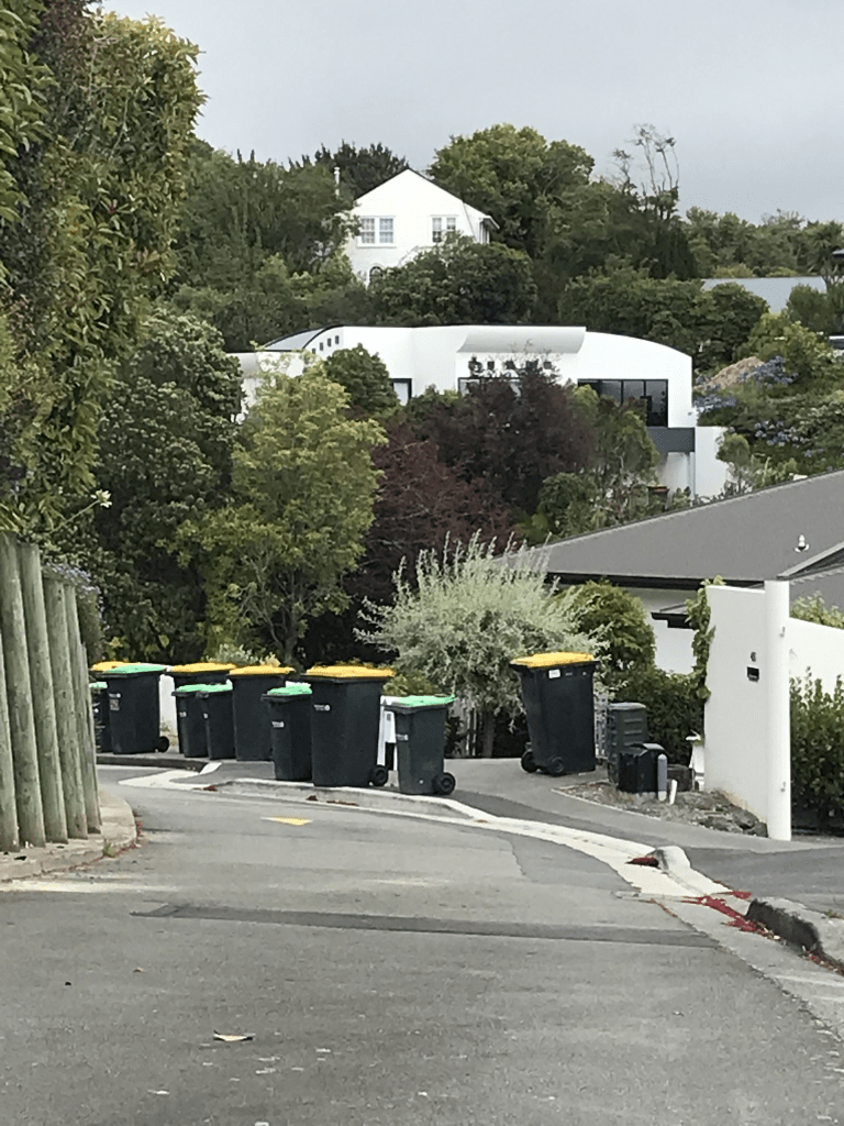
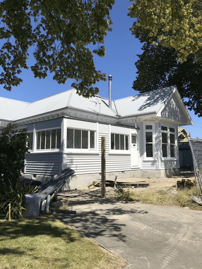
Most houses here were built in the 1960s and 1970s but there are still many older wooden villas from 1910s and 1920s. These older houses look gorgeous but not easy to see because of well established trees and gardens. There was one modern house that really intrigued me and I was seriously tempted to walk up their long driveway for a closer look. It had such a futuristic look about it. It is a narrow street with a narrow footpath and yesterday was rubbish collection day so I was frequently walking on the road. Great views from most of the street.
Whisby Road in Cashmere – Named after Whisby, a town in Lincolnshire, England. Whisby was home to the Cracroft family as early as the 16th century. John Cracroft Wilson (1808- 1881) was the son of Elizabeth Cleminta Wilson, née Cracroft. First appears in street directories in 1910.
A small amount of information from the library website and nothing that I can add about the name of the road. Papers Past proved to be interesting and explains why this tiny dead end street is called a road. The entries in 1959 and 1960 about milk deliveries had me looking at old maps. The map for 1930 doesn’t show MacMillan Ave but the map for 1941 shows MacMillan Ave cutting through Whisby Road. The map for 1958 shows Valley Rd and Whisby Rd connected. I can’t believe that I didn’t pick up on this when I wrote up Valley Rd and MacMillan Ave.
The milk dispute was about the milkman refusing to deliver milk to the residents on the street because of how steep the street was and his truck couldn’t manage to drive up it safely. One description was that it was a stinker of a street. The milkman offered two drop boxes with one at the Dyers Pass Rd end and the other at the MacMillan Ave.
There was a subdivision here in 1913 and by 1914 there was work requested by the 15 residents on drainage and a footpath. In 1927 there was a new path for pedestrians. In 1958 the road joined up with Valley Rd and the milk delivery dispute was in 1959 and 1960. In 1968 the decision was to close portion of the road between MacMillan Ave and Valley Rd. Most of the other entries were social notes plus death notices.
I was looking at my photos and realised that I actually walked it in August 2020. There is a walkway between Valley Rd and MacMillan Ave and another tiny walkway between MacMillan Ave and Whisby Rd. It is a steep wee walkway with a seat at the MacMillan Ave end. This walkway is where Whisby Rd used to run from Valley Rd until it was closed.
Only 4 houses here and one dates from 1910 and another from 1915. They are both gorgeous.
Westenra Tce in Cashmere – Named after the Frances Sarah Wilson, née Westenra, (1831- 1903).Frances Wilson was the eldest daughter of Captain Richard Westenra (1794-1880) and the wife of Frederick Herbert Wilson (1831- 1902), who was the eldest son of John Cracroft Wilson. They lived where this street was later developed. First mentioned in The Press in 1913 when land in the Cashmere Estate is advertised for sale. First appears in street directories in 1921.
A reasonable amount of information from the library website and nothing that I can add about the name of the street. Most of the entries on Papers Past were death notices and social items. In 1914 there were sections offered by Charles Clark. Charles Clark owned Thorrington Estate. There were more sections available in 1966. In 1932 the Westenra Street in the city had its name changed. Gordon Ogilvie wrote an article in 1979 and it included information about Mary Ursula Bethell living on the street in a cottage called Rise Cottage. She lived there from 1924 to 1934.
A mixture of older houses and more modern ones. One of the older wooden villas is being renovated and surrounded by scaffolding. Many of the properties on the upper side of the road had stone walls. I had an interesting conversation with a young man here. There is part of the street that looks like a footpath but is actually a parking area. There are no signs saying that it a parking spot. He said that they often get parking wardens trying to give them tickets but they get reversed. Further along the road there was a car parked on the footpath and it was right on the corner by Dyers Pass Rd and I had to walk onto the road including part of Dyers Pass Rd. Not sure if I liked this street.
Holliss Ave in Cashmere – Named after John “Jack” Chell Holliss (1900- 1968) Hollis was an architect in partnership with P. Leonard in the firm of Holliss & Leonard. He was a member of the Heathcote Borough Council, serving as chairman 1961-1964. He designed large Christchurch buildings: the port buildings at both Christchurch and Lyttelton, the steamer express building terminal at Lyttelton and the Amuri Motors parking building. First appears in street directories in 1964.
A reasonable amount of information from the library website. The unusual middle name of Chell is his grandmother’s maiden name. His obituary said that he was a well known architect and born in Lyttelton. There was a Holliss family that lived not far from where I grew up in Lyttelton so I had a good look on the ancestry website. Jack Holliss and Barry Holliss shared a great grandfather.
Most entries on Papers Past were about the community centre and Holliss Reserve. In 1962 there were 2 acres allotted for a reserve and a football ground. There was a letter to the editor in 1968 from a resident who was complaining about the proposed lido pool. He said that only the Huntsbury Hill people who want the pool so it should be built in their area and not in Cashmere. He doesn’t want his property devalued by the pool as he lives in a good value area and there is enough problems with the skating rink.
In 1971 there are plans for a reserve in what is now a cow paddock. In 1972 the playcentre building was approved. Several more entries and the councilors were still arguing about it in 1979.
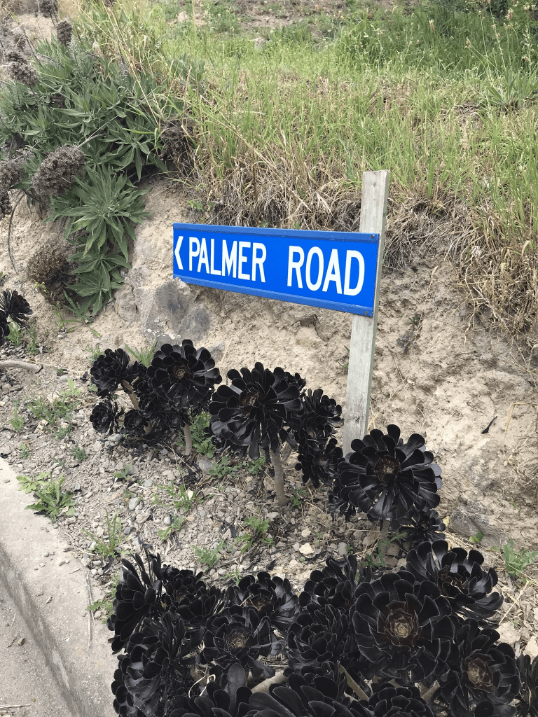
Most houses were built between 1960s and 1990s. A variety of house styles and one really stood out. It looked like a recent build and didn’t look like a house. The street wasn’t as steep as I was expecting but I did come across from Holliss Track. I was slightly puzzled at the top of the street as there is a sign saying Palmer Road but there isn’t another road. There is part of the street that doesn’t seem to have any houses but there are lots of brambles and it will be a good crop of blackberries unless they get sprayed in the meantime. One of the houses near the top was offering free fruit.
Takahe Drive in Cashmere – Named because it is near the Sign of the Takahe. Developed by Michael John Wood Davis, a surveyor and chairman of Cannon Estate Ltd. in 1959. First appears in street directories in 1964.
A small amount of information from the library website and I can’t find any link of the Cannon Estate to the Cashmere subdivision. The Cannon Estate was in the St Andrews Hill and Mt Pleasant area. I thoroughly searched Papers Past for this information.
Most entries in Papers Past involved ads for selling sections. In 1959 it is described as a new road stretching from Hackthorne Rd for 15 chains. In 1963 there were plans to extend Kidson Tce to connect to Takahe Drive. Still talking about it in 1966 and it obviously eventually happened as the two streets now connect up. In 1979 there was 5 hectares available for subdividing. Another ad describes 12 acres divided into 5 sections. In 1960 there is mention of developing Takahe Reserve and it is mentioned again in 1976.
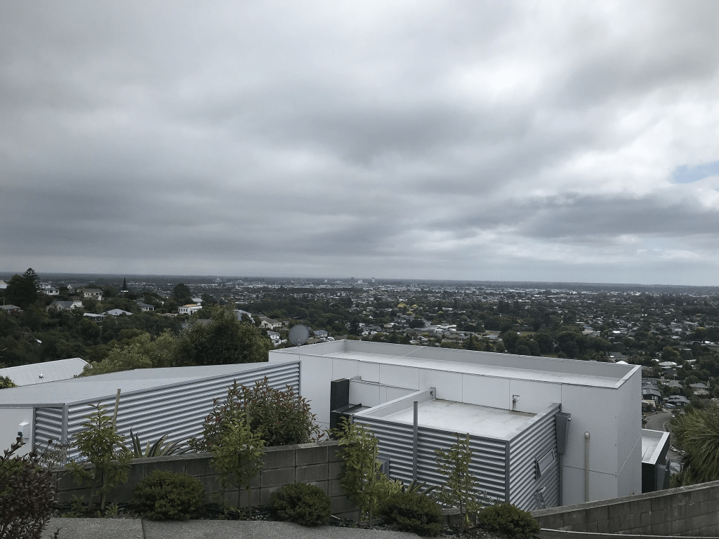
Most houses on the street were built in the 1960s and 1970s with one house at the Hackthorne Rd end dating from 1950. I managed to miss seeing the reserve but did see a signpost which I thought was for a walkway. I was on the other side of the road because that was where the footpath was. I looked at google maps and the latest street view is dated 2019 and the reserve is fairly obvious and hard to miss. I suspect that it was because of tree growth that I missed it today. Walking narrow hill streets on bin day isn’t easy and I frequently had to go onto the road but this street wasn’t as bad as some of the others that I walked today. Great views and the houses are built to take advantage of this. At the end where the the street meets Kidson Tce a dog decided to object to me walking past and the owner had to call it home. This was actually good luck for me as she was able to direct me to a short cut to Longhurst Tce. The short cut was steep but a pleasant walk in bush up to Longhurst Tce. There is usually another part of the track that leads direct to Holliss Track but that is now closed because of a new house being built on Iles Lane. There is a sign about this on the Holliss Track which I saw the other day so I knew to walk straight up to Longhurst Tce.
Stoddart Lane in Cashmere and nothing on library website for this tiny street. On Papers Past I found several entries for Agnes Stoddart saying that she lived on the Cashmere Hills. I found her obituary from 1956 which said she was 87 and the youngest daughter of Mark Stoddart the first settler in Diamond Harbour. She lived on Hackthorne Rd. I possibly still have the correct person except that she lived at 15 Hackthorne Rd which is right down near the Cashmere Rd end. Her niece who inherited her property continued living at the Hackthorne Rd address. I searched the Ancestry website and couldn’t find anyone with the surname Stoddart living where this street was formed. It could have been named after her sister Margaret Stoddard the artist. Agnes and Margaret are buried together at Bromley.
Only 11 houses here and they were built in 1990s and 2000s. Great views.
Thorrington Lane in Cashmere and no information on the library website. It obviously got the name because it runs off Thorrington Road. It looks like the lane was developed at No 3 Thorrington Rd which would make sense. The house was originally owned by a Campbell family who seemed to have lived there for many years. In 1969 Anne Lily Donohue MBE died and her address was 3 Thorrington Rd. She received her MBE in 1954 and going by her obituary she received it direct from the Queen rather than the Governor General. She was a Nurse Maude District Nurse plus involved with lots of groups. There are only 6 houses here and all were built in the 1970s. Looked like a driveway so didn’t actually walk it.
Thorrington Road in Cashmere – Underhill Road/Street was incorporated into Thorrington Road.Named after Thorrington, a house built on the banks of the Heathcote River, near the Cashmere Hills.Thorrington was the home of an estate agent, Charles Clark (1824-1906), who arrived in Christchurch in 1856. He was living at Thorrington at the time of his marriage in 1865. His son, Leonard Ernest Clark (1871-1932), built nearby Wairoa homestead about 1905 and his grandson Ernle was a celebrated aviator who lived at Thorrington for about 25 years. At one time it was said to have the best private garden in Christchurch and the Clarks hosted large garden parties here. First mentioned in The Press in 1904 when some of the land surrounding Thorrington was subdivided into 62 sections and sold. First appears in street directories in 1917.The section of Thorrington Road running from Cashmere Road to just past Wherstead Street was formerly named Underhill Road/Street. Mentioned in The Press in 1904. Shown on maps 1912-1950.
A reasonable amount of information from the library website. Papers Past didn’t have anything for Underhill Street and for Underhill Road there were a few death notices and sections for sale in 1904 and 1938. A possible reason the the Underhill name is that it was so close to the hill. Underhill is a surname but as this area seems to have part of the Thorrington Estate it is unlikely that it was named after a person.
Couldn’t find a mention of Underhill being changed to Thorrington. Sections were available in 1904 and 1907 and again in 1930s. Sections being available seem to match up with a Clark death. There was a death notice for Walter Scarff in 1944 as he lived on this street and Scarff Place is named after him. There was a dog dosing strip here in 1964 and there is always complaints about barking dogs. Is anyone old enough to remember dog dosing strips. When I was growing up we had one next to us in Lyttelton. I vaguely recall family getting upset one time because of the noise. The noise distressed my mother who was seriously ill.
In1969 the council stated very clearly that they had no intention of altering the purpose of the reserve or transferring it to provide a road. This was in response to the solicitors of RE and EL Morris who were planning on subdividing their land. The Christchurch Bible School was mentioned in 1972 and it gave a full description of their property.
Most houses on this street were built in the 1970s and 1980s but there are still a couple from 1910. There are some lovely older houses here but a couple of the modern ones are really ugly and look out of place. There is a playground next to the entrance to Ernle Clark Reserve. There also seems to be an empty section that is fenced off and there is possibly a dispute over the status of this land. There is a section of land near Ernle Clark Reserve where a developer wants to cut down native trees but there is a caveat on the land but I don’t know if it this fenced off section.
Woodbridge Road in Cashmere – First mentioned in The Press in 1904 when Thorrington, “one of the oldest estates in the vicinity of Christchurch” was “disposed of in lots”. First appears in street directories in 1908.
A small amount of information from the library website. Papers Past had several birth and death notices. There were sections for sale in 1904, 1907 and 1909 plus a subdivision approved in 1973. In 1967 the name Thorrington was approved for a new Post Office on the corner of Colombo St and Woodbridge Rd. It officially opened in 1970. There was was horrible incident in this street in 1964 where a woman burnt to death in her kitchen. Going by the details in the report it sounded like a suicide.
There are still several houses here from the 1910s and 1920s plus another group of houses from 1970s. The older houses are lovely and there is one house from 1910 that is being renovated.
Overdale Drive in Cashmere – Named after Overdale in Yorkshire. The name was suggested by Bruce Carey, a long serving committee member and also chairman of the Rhodes Home board. The Rhodes family had emigrated from southern Yorkshire. Formed on a subdivision of the horse-paddock slope in front of the Rhodes Memorial Convalescent Home in 1991. First appears in street directories in 1993.
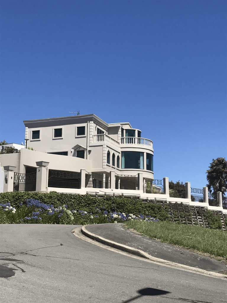
A reasonable amount of information from the library website and nothing that I can add to it. Most of the houses here were built in the 1990s and 2000s. The more recent houses are huge and I have finally figured out what I find slightly weird about some of these houses. They look like posh hotels. The buildings that take up most of the street is a retirement home called Rhodes on Cashmere and it is described as a boutique retirement home. That is another word for expensive. I did like the house that was flying a pirate flag. At the end of the street there is a walkway down to Purau Tce.