St Vincent Tce in Cashmere – Named after HMS St Vincent, a naval training school in Gosport, Hampshire.Named during World War II by John Glasgow Taylor, a builder. His son, Sub Lieutenant John Charles Taylor (1920?-1943), had trained at HMS St Vincent, the Royal Navy’s training ship for young sailors at Gosport, Hampshire and was killed in an aircraft accident on 10 April 1943 while serving with the Royal New Zealand Naval Volunteer Reserve in North Africa. First appears in street directories in 1946. John Glasgow Taylor is a resident.[Gordon Ogilvie said in 2008 in an interview with Margaret Harper, that the information about the street name was given to him by local residents when he moved into the area in 1968.]
A lot of information from the library website and I couldn’t anything on Papers Past about the naming of the street. It doesn’t appear on early maps but neither does the nearby Merlewood Ave which was a street from 1914. The earliest information on Papers Past is from 1950 and mostly death notices. John Glasgow Taylor lived in Ruskin St until 1946 and then he moved into 1 St Vincent St. His brother also had Glasgow as a middle name and it was their mother’s maiden name. Half the houses here were built in the 1020s including the one that John Glasgow Taylor moved into. They have no connection with Thomas (Tommy) Edward Taylor who is responsible for the naming of nearby Merlewood Ave. I suspect that this was an unnamed right of way for the 4 or 5 houses that were here.
It is a steep and narrow wee street with no footpath. The houses are lovely especially the 1920s wooden villas. If a friend who lives on Merlewood Ave had looked out of her window she would have seen me waving at her house. The resident that I chatted with thought that I am mad to be doing so much walking but wished me luck.
Sloan Tce in Cashmere – Part of Hunter Terace (south)Probably named after Patrick Bernard Sloan (1887?-1965). In 1936 Sloan, a carpenter, is listed in street directories as living at 139 Western (later Waimea) Terrace where this street was later formed. The southern part of Hunter Terrace was named Sloan Terrace in 1961 after Thorrington School was built. First appears in street directories in 1964.
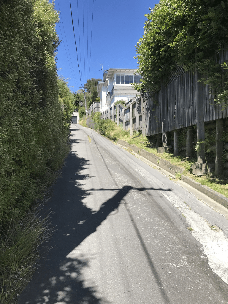
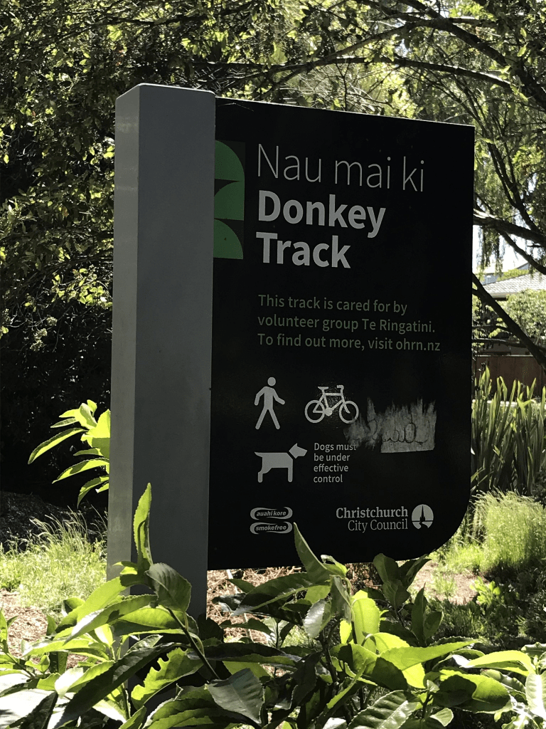
A small amount of information from the library website and there are mistakes in this information. Patrick Sloan did live at 139 Waimea Tce but that house is still there and it is on the other side of the river from Sloan Tce. There isn’t a street formed at 139 Waimea Tce. Patrick Bernard Sloan was born 7th March 1885 and died 1st February 1965 and he grew up on Simeon St. It is interesting that when he died he was living back on Simeon St in what as possibly the same house where he grew up. He lived at the Waimea Tce address from 1941 to 1949 and from 1949 to 1961 he was living at 9 and 15 Centaurus Rd. Sloan Tce was developed at 15 Centaurus Rd and Remeura Tce was developed at 9 Centaurus Rd. In 1951 there was an issue with his subdivision as the council and the Sloans were disagreeing about a towpath along the river. They owned 8 acres of land at the Cashmere end of Colombo St and their plan was to subdivide the land into 40 sections. The road was developed as far as the towpath which I suspect is now what is known as the Donkey Track. I am not sure how it was called Hunter Tce South as it wasn’t ever connected to Hunter Tce. I had a good look at early maps especially the ones from 1950s. The couple owned other blocks of land including one on the Main South Rd.
This street has houses on only one side of the street as the Heathcote River is on the other side. The street is on the high side of the river. None of the houses stood out for me and most were built in 1950s and 1960s. There is an entrance to the Remuera Reserve near the end of the street. At the end of the street there is the Donkey Track and this is a pleasant short walk that takes you to Malcolm Ave.
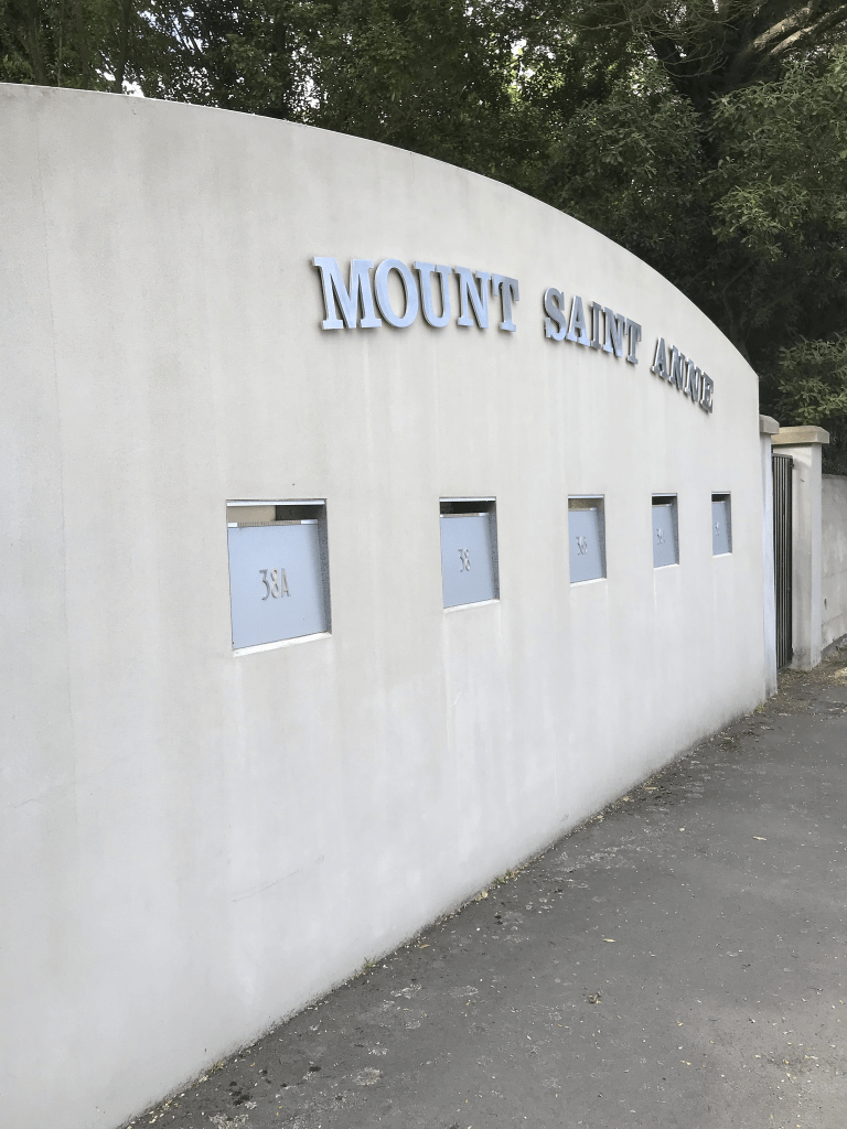
Remuera Ave in Cashmere – Remuera Road first appears in street directories in 1955. Becomes Remuera Avenue in 1964.
A tiny amount of information from the library website. Most entries on Papers Past were ads for selling sections or houses. There were 27 sections available in 1957 and most houses here were built in 1950s and 1960s.
The street runs from Colombo St by a shopping centre and curves around to Centaurus Rd. None of the houses stood out for me but there is a reserve and a playground near the Centaurus Rd end. I actually walked the street twice today as I ended up walking in a figure of eight. I was going to attempt a Wherigo geocache that starts here but I couldn’t figure out what to do. I have now played with the app on my phone and I think that I have figured it out so I will have to go back to this street.
Edited because I found out extra information where researching Sloan Tce. This street was a tiny cul de sac in the 1950s and it expanded to Colombo St when the land was subdivided. Patrick Bernard Sloan and his wife owned 8 acres of land in this area which they started subdividing in the 1950s and after a couple of issues with the council finished subdividing in the early 1960s.
Purau Tce in Cashmere – Named after Purau, the estate of the Rhodes family on Banks Peninsula. The Rhodes Memorial Convalescent Home was built in 1886 with help from money contributed by the sons of Robert Heaton Rhodes (1815-1885). The street was formed on a subdivision of land belonging to the Home in 1952. First appears in street directories in 1957.
A small amount of information from the library website and nothing I can add about the name. You can borrow from the library a book called Rhodes on Cashmere: a history of the Rhodes Memorial Convalescent Home. It is a good read.
Not many entries on Papers Past apart from a few death notices. In 1953 there were sections for sale on behalf of The Rhodes Memorial Convalescent Home.
I had walked down through the Purau Reserve and was pleased that I could walk back to my car on the flat from this street. This looked like a lovely street and most houses had lovely gardens. Most houses were built in the 1950s but the one that caught my eye looked modern. Not sure if I liked it but it certainly stood out.
Nutfield Lane in Cashmere and it isn’t on library website. I suspect that the name for the street is because of all the trees on the property and likely to have included nut trees.
Most houses here were built in 1950s and there were a few death notices. There were sections available in 1967 and they were described having frontage to an artificial lake and each section includes a portion of the woodland. The owner of the land died in 1964 and his obituary said that he died at his home in Kirwee. By 1969 his widow was living at 6 Nutfield Lane. Most of the houses here were fairly ordinary looking but No 6 Nutfield is an interesting looking building and it is now Lotus Day Spa. There was also an older looking house on the corner with Colombo St called Nutfield House yet it seemed to have a Colombo St address. The owner of much of the land in the area was Leonard Ernle Clark and there is a nearby reserve with his name. Lots of entries for him on Papers Past because of his flying history. I was surprised that there isn’t a wikipedia page for him. He owned the Thorrington Estate. His grandfather Charles was the original owner of Thorrington Estate and it was much reduced by the time Ernle Clark took over the estate from his father Leonard Clark. I am confused why the obituary said his home was in Kirwee as the electoral rolls have him living at 6 Nutfield Lane.
Majestic Lane in Cashmere – Named after the Majestic Theatre, until 2014 at 126 Manchester Street, Christchurch. Named because it was developed on the site of a property used by the New Life Centre, an organisation which also used the Majestic Theatre. The site was part of the old Thorrington estate. The old Wairoa homestead and a block of flats were demolished and eight sections were sold. Developed in 1994.
A small amount of information from the library website. There were a few entries on Papers Past about 16 Thorrington Rd where this lane was developed. The owner of the Thorrington Estate subdivided his land a few times. In 1970 part of the Thorrington Estate comprising of 9 flats and over 2 acres of woodland were sold. That same year there was an application by the New Life Centre for a permit to allow a residential Bible Study School to be set up. The 9 flats would be converted into living quarters for the students. The main house to be admin and lecture rooms. The property was obviously sold again in the 1990s but Papers Past doesn’t cover this period. The buildings were demolished and land divided into 8 sections. All the houses here were built in the 1990s and they are huge. One house right at the end I suspect has been built to resemble the original big house that was on the property. Wish that I could have got a photo of it. There was also a wee footpath to walk on for most of the lane.
Lucknow Place in Cashmere – Named after Lucknow, the capital of Uttar Pradesh State in northern India. One of the streets in Cashmere given the name of a place in India. First appears in street directories in 1991.
A small amount of information from the library website and the Indian names for Cashmere are because of John Cracroft Wilson. He owned a huge amount of land on the hills here and had a history with India.
Most houses were built in the 1990s but some were built within the last couple of years. I was surprised that I hadn’t walked this street as I have walked the nearby Bengal Drive. When I checked google maps I realised why I hadn’t walked it. Most the street had been blocked off as there were 2 or 3 houses being built. I would love to have got a photo of one of them as it was an amazing looking house.
Rossmore Tce in Cashmere – Named after the Rossmore family. The Rossmores were aristocrats with connections to the Westenra family. Captain Richard Westenra (1794- 1880) was a “grandson of a former Lord Rossmore”. Frederick Herbert Wilson (1832-1902) and Frances Sarah Wilson, née Westenra, (1831-1903) named their eldest son Rossmore Cracroft Wilson (1863-1942). First mentioned in The Press in 1912. First appears in street directories in 1921.
A reasonable of information from the library website and that is a seriously weird description of Lord Rossmore. Using the words former Lord Rossmore is strange. Captain Richard Westenra father was the third Baron Rossmore and his grandfather was the second Baron Rossmore. Captain Richard Westenra’s mother was Baron Rossmore’s second wife. The first Baron Rossmore didn’t have any children and the title went to a nephew.
Papers Past had lots of entries especially in what was called Social Notes. A family with the surname Maling is frequently mentioned. In 1922 there is mention of the need for a footpath from Rossmore Tce to the Consumption sanatorium and in 1926 there was mention that the footpath from Rossmore Tce to Sanatorium Hill is to be asphalted. The year 1933 had several entries as the septic tank and old trees at the corner of Cashmere Rd and Rossmore Tce were being removed so that a plantation can be planted.
The same year there was a very sad story about a young boy who fell into a quarry. This happened in July of that year and it was said that he fell 50 feet over a bank into the quarry. He broke his thigh and right arm plus had internal injuries. The note from the hospital said that he was seriously hurt but improving. The quarry was on private land and fenced off. The broken thigh and leg didn’t heal properly so they operated on him in the September but he died after the operation.
The year 1946 was another busy year as a man was charged with running a common gaming house on the street. This was the same year that a new convent was opened on the street. The description is that it was a new juniorate of the sisters of the missions and first of its kind in the South Island. Reading further articles it sounds like it was a place where they trained novices to be fully fledged nuns.
There were sections for sale in 1969 and 1971 and I was going to look up Mr E Maling to see when he died as the Maling family seemed to be the main householder on the street.
In 1974 two young men wanted to establish a grass ski run on this street but they withdrew their application because of the number of objections. They possibly continued doing this on an informal basis as there is a photo dated 1975 of a young man grass skiing. The footwear looked like modified roller skates. Growing up in the 1950s and 1960s we had toboggans that we used in the paddock next to our house in Lyttelton. The sheep stayed out of our way.
I walked this last night and I ended up having a lovely chat with a local. Part of the old convent fell down in the September earthquake and the rest fell in the February earthquakes. She said that it came down with a lot of noise. She also said that it was rumoured that naughty nuns who had been impregnated by priests were sent to this convent. I think that the church this owns this property. In this flat section of the street there were several houses built in the 1920s but they were on the high side of the street up long driveways. The glimpse that I managed to get showed gorgeous wooden villas. Most of the houses here are on only one side of the street because of the long drop on the other side of the street. On the lower part near Centaurus RD is the only part where houses are on both sides. At the top of the street there are huge modern houses which are unbelievable. Anyone got a spare couple of million to give me. At the top there looks like there is a walkway that leads to Whareora Tce but I didn’t attempt it as I had done of a lot of walking on steep roads and was getting tired.
Roseneath Place in Cashmere- First appears in street directories in 1970.
A tiny amount of information from the library website and my best guess about the name of the street is that it is named after a place in Scotland.
Not a lot that I can say about the street except most houses were built in the 1960s and 1970s. Looks like a few rebuilds and at least one empty section. Not much information on Papers Past and the entries were mostly ads in 1967 for the sale of sections in the Cashmere Downs subdivision. In 1973 a driverless truck rolled down the hill and hit the house at No 2 Roseneath Place. Thankfully the woman in the house was unhurt. When the men were using some sort of loading arm on the truck the brakes failed. The men chased the truck but were unsuccessful at trying to stop it.
It is a steep wee street but good views at the top.
Paulus Tce in Cashmere – Named after Petrus Paulus Hendrickus Blokker (1930?- 1982).Blokker was a mechanic and freezing worker. His signature appears on the two subdivision plans that laid out the right-of-way. First appears in street directories in 1964.Information supplied in 2007 by Bob Pritchard, subdivisions officer, Christchurch City Council.
A small amount of information from the library website. Most entries on Papers Past were sections for sale in 1966 and 1969 and these ones would have been the Blokker subdivision. The two sections for sale in 1977 was from land belonging to someone who lived on Whareora Tce, He wanted to develop the land at the back of his property.
Paulus Blokker had a few dealings with the council over the subdivision and there was apparently an easement causing issue. Paulus argued that it was an ancient right of way that is now obsolete. The council solved the problem by selling a narrow strip of land to Paulus for £50 in exchange for the council to be able to continue to use the easement. This was all happening in the 1960s and in 1971 when building the houses there was an incident involving a 5 ton truck. The truck lost control on the steep road but luckily the truck driver wasn’t hurt. It did cause a bit of damage. It is mind boggling to think that any truck was able to get up this steep and narrow street which is still signposted as a right of way.
The next story that mentions this street was in 1975 and it involved a very interesting bankruptcy story. The bankrupt man claimed to have purchased a house on this street and then resold it for $107,000.00. That is a huge amount of money for those days.
Paulus Blokker was frequently described a a freezing worker but he also farmed pigs in the Harewood area. Was fined for pigs wandering on the road at his Harewood property. His application to open two pigs on Lower Styx Rd was declined in 1966. Busy man.
I walked this last night and can I just say that it is very steep especially if you have already walked 10km for the day. I will confess that I only walked part of it as there wasn’t a footpath. I didn’t take up the offer to pick plums from the plum tree as I always use a backpack when out walking and they would have got squashed by the time I would have walked to the car. Thanks to the local who made the offer. I met some very friendly people on my walks in this area.