Cromer Place in South New Brighton- Named on 21 February 1962.
A tiny amount of information from the library website. Not much information on Papers Past as it was mostly ads and a few death notices. My best guess about the name of the street is that it was named after Cromer in England. I still regret not exploring Cromer when I was in the UK. I drove through it when I was on my way to Wells-Next-to-the-Sea and I always meant to return.
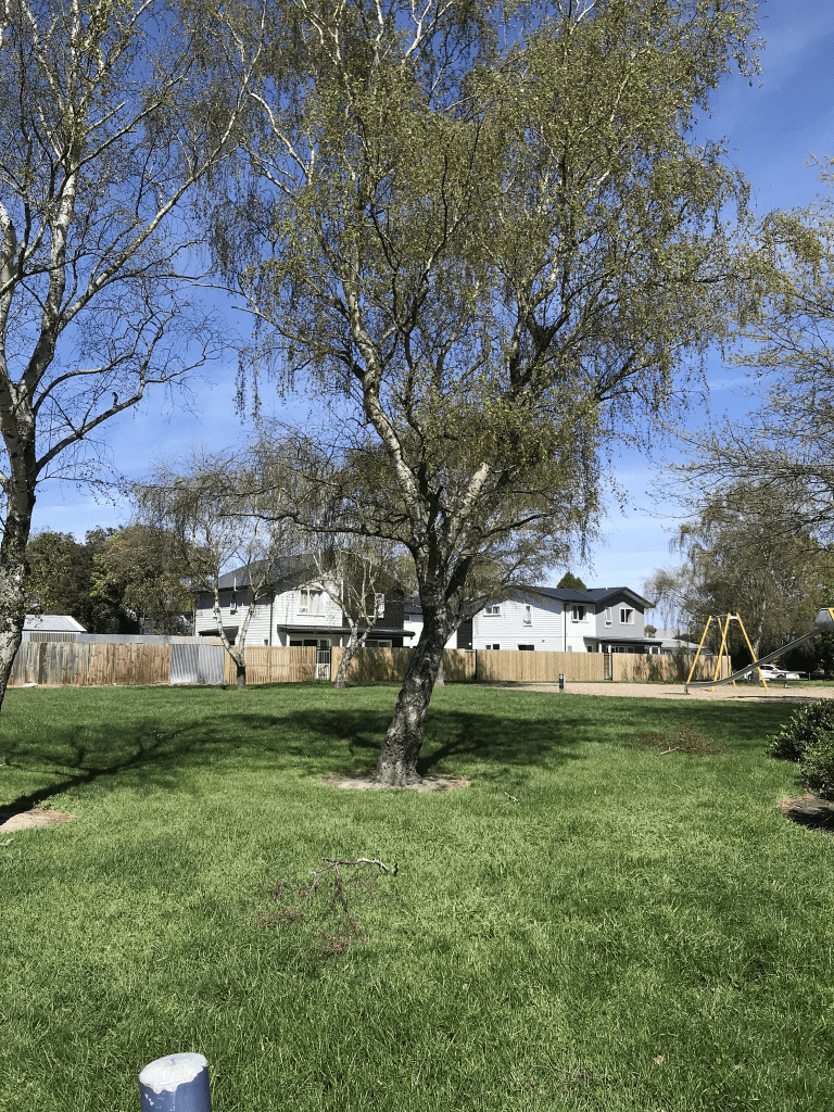
Most houses on the street were built in the 1960s and none of them stood out for me. Some nice gardens and the footpath was on both sides of the street which is always a plus. I didn’t take any photos.
Pukeko Place in South New Brighton / Southshore and there wasn’t anything on the library website about this street yet the houses here date from 1980s. Street was obviously named after a bird.
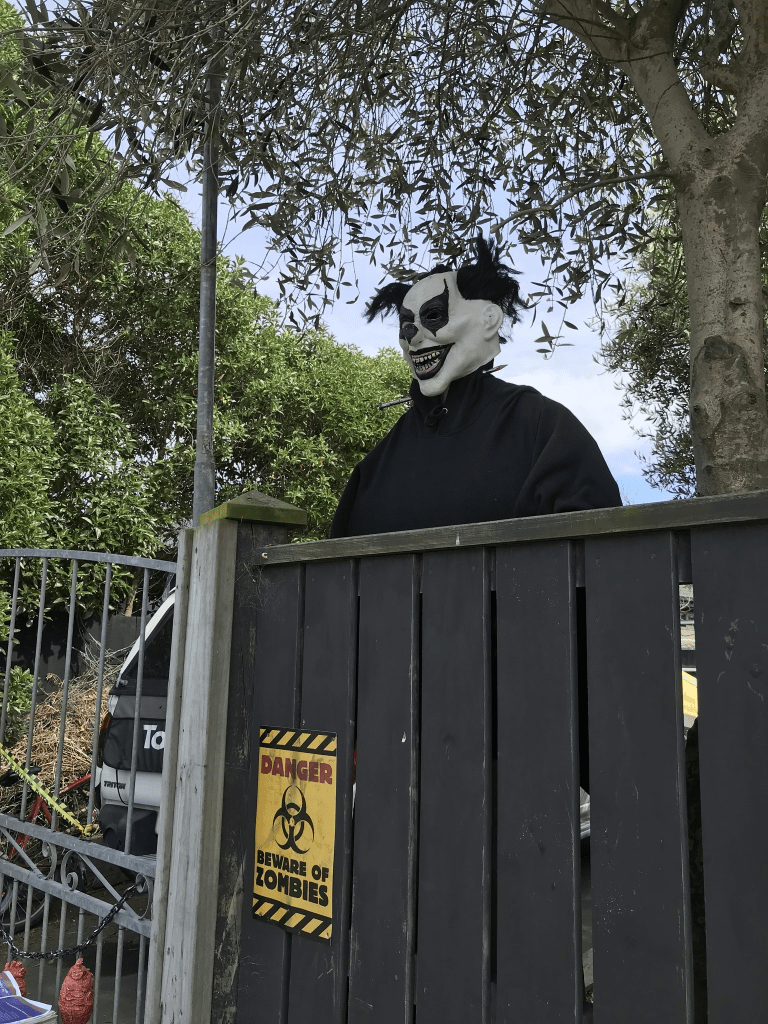
I had been geocaching in the area and parked on this street as there was an entrance to Southshore Spit Reserve from this street. There were a couple of nice houses here and it looked like a pleasant street. I loved the Halloween decorations at a house and was a bit surprised that they were still up as it is the 2nd November.
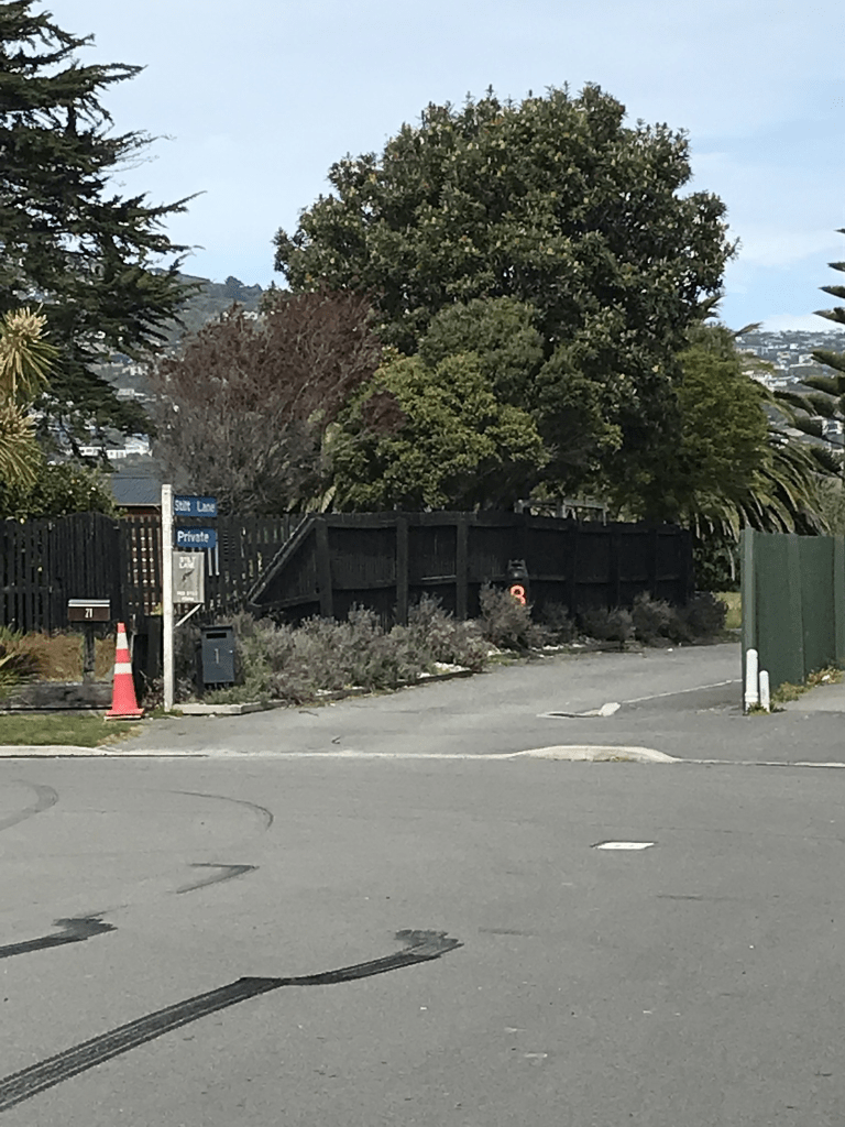
Stilt Lane in South New Brighton or Southshore and nothing on library website for this private lane. The library has the nearby streets in South New Brighton but google maps and real estate agents have it in Southshore. Only a couple of houses here and one dates from 1980 and the other from 2015. The lane leads to an entrance for Southshore Spit Reserve. Only part of the lane was sealed and the rest was just a grassy track. The lane is named after a bird.
Heywood Tce in Richmond – Named after Heywoods, the home of George Bowron (1806- 1891) on the East Belt (later Fitzgerald Avenue)Bowron bought Rural Section 33, 50 acres on the “North Bank Avon, near Cemetery”, in 1851. He was Registrar of Joint Stock Companies, of Deeds and Deputy Commissioner of Stamps. He named his house, Heywoods, and farm, The Heywood, after Sir Benjamin Heywood, a friend of his in England, and his family. His son, George Bowron jnr. (1838-1915) farmed The Heywood, and later Banner Downs, Fernside, in partnership with Samuel Heywood (1839-1896). George Ivall Heywood (1859-1892) was the son of Joseph Martin Heywood (1832-1904), a carrier, and probably a relation of Samuel Heywood. He is listed in street directories 1887- 1890 as living where Heywood Terrace was later formed. Moritz Bowron (1845?-1933) is listed in street directories as a neighbour of George Heywood in 1890. First mentioned in The Press in 1893 when building sites in Heywood Terrace are advertised for sale after the Heywood Estate was subdivided into 221 sections. First appears in street directories in 1896.
A huge amount of information from the library website and I couldn’t find any connection between Samuel Heywood or George Ivall Heywood to Sir Benjamin Heywood. Samuel Heywood’s father was Richard Heywood. George Ivall Heywood’s father was Joseph Martin Heywood.
A reasonable amount of information from Papers Past and there were sections for sale between 1893 and 1900 and all described as being close to tram and boat sheds. Found a couple of entries in 1893 that described Heywood Tce as a magnificent new street where the vendors had formed, channelled and metalled the street at their own expense. Another entry in 1893 said that land from the Heywood Estate had been sold and it was just above the Union Rowing Shed. Land had been known as Bowron’s and had been in the family for some 42 years. Lots of birth and death notices. The corner of Draper St and Heywood Tce seemed to have a lot of accidents frequently involving taking the corner at speed.
I did rather sidetrack when researching this street as George Bowron’s obituary in 1891 said that he owned a large portion of what is now Richmond plus that he came to Christchurch on one of the first four ships. I went checking as obituaries for at least three of his children said that they came out in 1851 on the Bangalore. Found the passenger list and the family came out on the Bangalore. I also sidetracked checking out the Heywood families.
The houses on this street cover every decade from 1905 to 2023. One house from 1910 looks very sad. There were about six older houses but they didn’t really stand out for me. I even almost liked a couple of the modern houses.
Harvey Tce in Richmond – formerly Windsor Terrace. Named after Patrick Harvey (1880?-1949).Land for sale in Windsor Terrace is advertised in the Star in 1893. Windsor Terrace first appears in street directories in 1896 as a “continuation of Draper Street”. Re-named Harvey Terrace on 1 September 1948 when 120 streets were re-named. Harvey, a teacher, was the secretary of the SINZ Motor Union and a longtime resident of the street. Information about the naming of Harvey Terrace supplied in 2007 by Allan Williamson in an interview with Margaret Harper.
A reasonable amount of information from the library website. Not much information about Patrick Harvey on Papers Past but he was assistant teacher at Sumner School in 1918.
In 1893 there were six sections sold on this street. Complaints about drains in 1902 and in 1910 there were complaints about the damage to the roads from traction engines. Lots of death notices. The street changed it’s name in 1948 and for a couple of years articles called it Harvey Tce formerly known Windsor Tce. In 1960 an 80 year house was sold and it is probably why sections were available in 1960s and 1970s. Tennis club is mentioned a few times.
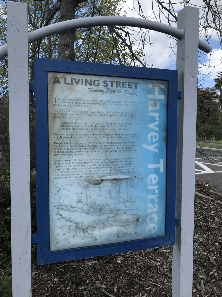
I did like this street when I walked it but houses are mostly only on one side of the street now and the other side is in the red zone. Many houses date between 1960s and 1980s with a few built since the earthquakes. One house is from 1920 and another from 1910. I did like a house from 1905 but wasn’t quite so sure about the other house from 1905. The tennis club seems to be still there but didn’t see any club rooms. I looked at google street view from before the earthquakes and there were some gorgeous older houses. So sad that they have gone. This street is a living street and there is a noticeboard with information on it. It claimed that the area was called Daisyfields but I couldn’t find anything on Papers Past about this.
Draper Street in Richmond – First mentioned in the Star in 1881 in an advertisement. In 1883 it is referred to as Draper’s Street. No-one with the name of Draper lives nearby. First appears in street directories in 1887.
A tiny amount of information from the library website and I found an article in Papers Past from 1938 which gives the reason for the name of the street. It was apparently called Draper St / Draper’s St because three of the leading drapers lived on the street. Note the suburb was called Bingsland until the residents petitioned for it to be changed. The earliest mention that I found on Papers Past was from 1881 where a J Hadfield was selling his estate. The residents in 1895 petitioned for the street to be channelled and asphalted. Several complaints about drains. Lots of death notices and a few birth notices. In 1926 the Richmond Burgesses Association suggested that Draper St and Swann’s Rd become one name. This obviously didn’t happen. The street is on a map from 1879 but it isn’t named.
There is a shop on the corner of Draper St and Stanmore Rd and next to the shop there looked to be a commercial block. My usual website for giving me dates for houses wasn’t working properly for this street. Many houses look like they date from the 1970s and are multi dwelling type of housing. Several would have been built in the last couple of years and older houses on large sections have been replaced with multiple units. There is at least one house from 1915 but the saddest house is from 1890. I was really surprise to realise that the house from 1890 is actually being lived in as it looks like it is falling down. The grounds are so overgrown that I couldn’t get a photo. I didn’t particularly like this street and felt a bit claustrophobic here. I think that it was because of the houses all being crammed together.
Templar Street in Richmond – formerly Templer Street. Named after John Arthur Templer (1817-1885). Templer bought 73 River Road in 1876, a large estate of 100 acres. Templer Street first appears in street directories in 1887. Made a public street from 1 January 1888. Becomes Templar Street in street directories in 1917.
A small amount of information from the library website. I couldn’t find out why they changed the spelling of the street name. A map from 1912 had the Templar spelling. Not a huge amount of information on Papers Past and until 1904 there was also a Templer/Templar St in Sydenham. The earliest mention that I found for the street was when flowers were stolen in 1885. Several death notices. A house was destroyed by a fire in 1890. Several entries between 1909 and 1913 about a pumping station to be built. I did find a wedding notice in 1922 that related to my Barrett family tree. The death notice for John Arthur Templer was very brief and just said that he died at his residence aged 68 and was late of Narrambla, NSW. John Arthur Templer emigrated to Australia with his brother Edward Merson Templer in February 1940 in the barque Hope. They purchased a mill which was renamed Templer’s Mill. They operated the mill until 1870 when they went bankrupt so they sold up and moved to New Zealand. This information from an ancestry page claims that the house that they built is still standing but this is unlikely as it would have been in the red zone. There is a photo of John Arthur Templer’s grave on findagrave. At least one member of this family moved to Orari and Geraldine. One claim to fame is that John and Edward’s nephew was Andrew Barton Paterson AKA Banjo Paterson.
I had time to be able to walk a couple of streets before visiting Bill Sutton’s house as part of the Heritage Festival. The house was built in 1963 and is the only house left standing on this street. It was apparently quite a battle to prevent this house from being demolished. Looking at google street view from before the earthquakes it looks like it was a very pleasant street.
Vicki Street in Sockburn and there wasn’t any information on the library website about this street. I searched but couldn’t find a reason for the name and it is probably named after a person. Not much information on Papers Past. The street was extended in 1960. The reserve was created in 1957 and called Vicki Reserve. I checked older maps and it originally ran off Tensing Place but was extended to Curletts Rd. I did find one entry in the court news where it was called Vicki Place. I suspect that this street was the one originally called Everest Ave. There was only one entry for Everest Ave and that was in 1953 when the three streets were named.
Not many houses are privately owned and most date from the 1950s. The houses are very obviously state houses and several have been demolished and new high density units are being built. There is an entrance to Riccarton High School here and I have frequently driven past this street and didn’t realise that there were houses on it. I honestly thought that it was just an entrance to Riccarton High School.
Tensing Place in Sockburn – formerly Tensing Street. Named after Tensing Norgay (1914-1986). Tensing and Sir Edmund Hillary became the first climbers to conquer Mount Everest in 1953. In a block of 28 acres in Curletts Road between Blenheim Road and Riccarton bought by the government for state housing in 1953. The land was formerly owned by Pyne, Gould, Guinness Ltd. Named Everest Crescent on 10 August 1953. Re-named Tensing Crescent on 12 October 1953 as “the name Everest Crescent had already been taken”. First appears in street directories in 1957. Minutes and report of meeting of Housing Committee of the Paparua County Council held on 10 August 1953 & 12 October 1953, held at Christchurch City Council archives.
A reasonable amount of information from the library website and I couldn’t find any evidence that it had been originally called Everest Crescent.
Papers Past had a few entries but most were ads for someone who was a colour therapist. I had to google this and it is also called chromotherapy and was described as quarkery.
In 1953 it was mentioned that the three streets in the new housing block and named Everest Ave, Hillary Crescent and Tensing St which is why I think that the library information is wrong. One day I am going to have to try and access the council information. In the same year of 1953 the NZ Alpine Club requested that the street names of Tensing and Hillary be swapped over so that Hillary Crescent is the name for the more prominent street. This was agreed to by the council. Also in 1953 it was mentioned that trainee builders would be working on the units being built in the street. A few houses were for sale in 1954 and in 1957 residents of this street plus nearby streets requested a bus service.
A few death notices and one said late of Lyttelton but I didn’t recognise the name.
I walked this street after visiting a quilt exhibit at Riccarton High School. Many houses still look like State Houses / Housing Corp/ Kainga Ora but a few are privately owned. Most houses were built in the 1950s but there is a block of units that were built in 2022. There were a couple of houses that were looking a bit neglected and I wouldn’t be surprised if Kainga Ora demolish them and build new units on the land. They would probably be able to fit at least 20 units on the land that is currently occupied by two houses as the sections were huge.
There was a footpath on both sides of the street but in many cases I had to walk on the grass verge because of the vegetation blocking the footpath. Can’t say that I particularly liked the street plus it is too close to a school for me. The street runs off Curletts Rd and traffic on that road can be a nightmare.
Four Peaks Drive in Wigram – Named after Four Peaks Station, near Fairlie in South Canterbury. Continues the theme of high country farms used for street names in the Broken Run subdivision. Named in 2015.
A small amount of information from the library website an nothing that I can add about the name of the street.
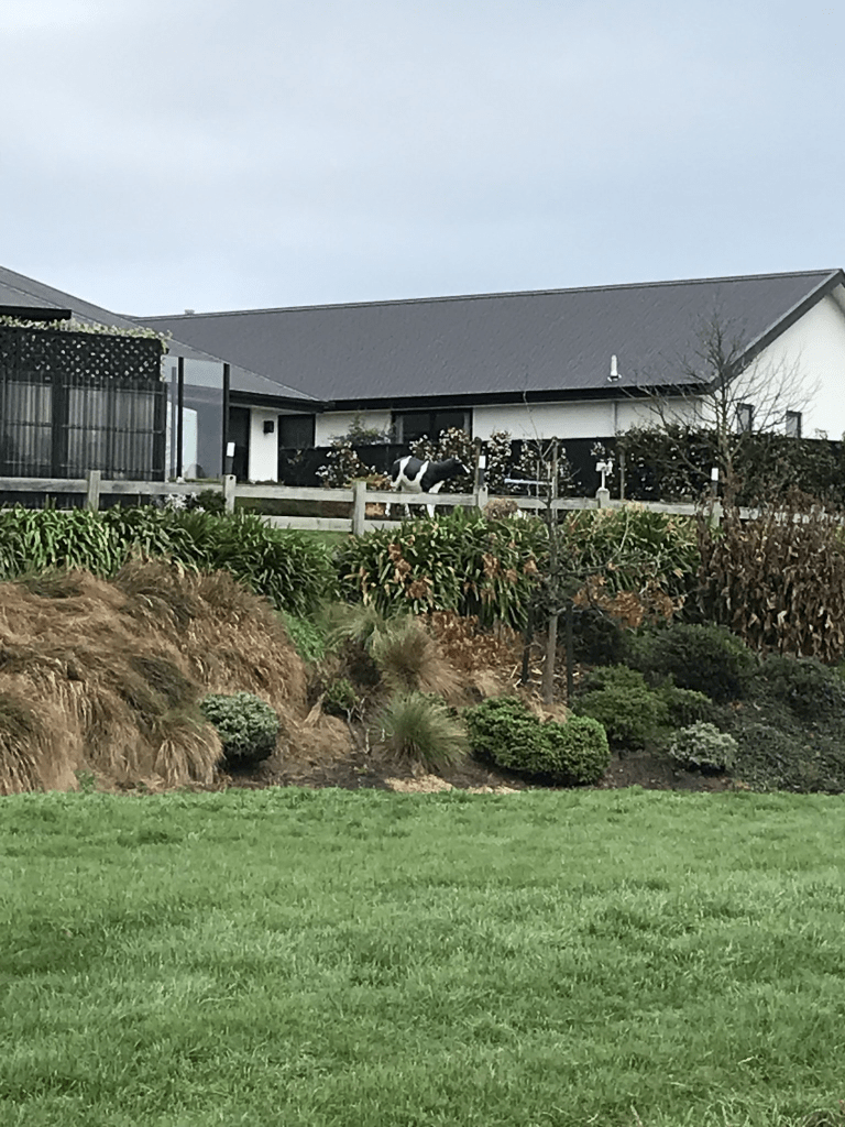
The houses here were built between 2015 and 2018 and none stood out for me. Most had immaculate lawns with a few shrubs but one had long overgrown grass. One house here sold for over a million last year but it a very ordinary looking house. The letterbox was more interesting than the house. There was one house near the Wigram Rd end that I would love to have had decent look at the garden but it was on a back section. I had walked through West Broken Run Reserve which runs along the back of the houses. The Heathcote River goes through this reserve but it doesn’t look like a river here. I actually thought that it was a drainage ditch. What I did see was a fake cow looking over a fence which is why I would love to have had a good look at the garden. I do like quirky stuff.