Clementine Lane in Mt Pleasant – Named after Clementine Way, a street in the Wellington suburb of Chartwell. Cannon Estate Ltd., developers of the subdivision where this street was formed, also developed Chartwell in Wellington. Chartwell in Kent, England was the family home of Sir Winston Churchill (1864- 1975) and his wife, Clementine. Named in 1967 and first appears in street directories in 1972.
A small amount of information from the library website and nothing that I can add about the name of the street.
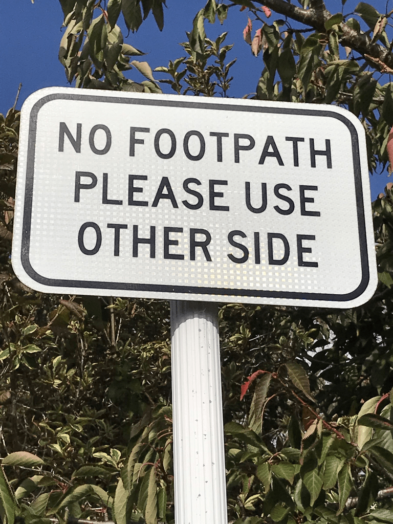
Not much information on Papers Past and there was mostly ads for houses and sections plus a few death notices. Most houses here were built in 1970s but most looked more modern. There wasn’t a footpath on this street but it was a narrow one.
Michael Ave in Mt Pleasant- Named after Michael John Wood Davis (1926-).Davis, a surveyor, was chairman of Cannon Estate Ltd., developers of the subdivision where this street is formed. First appears in street directories in 1966.
A small amount of information from the library website and nothing that I can add about the name of the street.
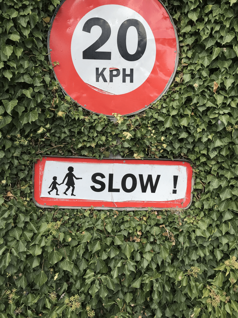
Papers Past had mostly ads for section and houses for this street. There were a few modern houses here including a really ugly one that looked like a shed. Wish that I could have got a photo it. Most houses here were built in the 1960s. There was a footpath on only one side of the street and I was amused that there was a sign saying this. There were some nice gardens on this street.
Menlo Tce in Mt Pleasant – formerly part of St Andrews Hill Road. Named after Menlo in Galway, Ireland. Named by Walter Edward de Thier (1926- 2003). His mother lived in Menlo before emigrating to New Zealand. First appears in street directories in 1939.
A small amount of information from the library website and I don’t think that the information is correct. I checked various old maps none of them showed this tiny street as being part of St Andrews Hill Road. Walter Edward de Thier also lived in North Canterbury plus going by his DOB he would have been 13 years old when he named the street. The street is more likely to have been named after Walter Charles de Thier (1883 – 1973) who lived in this area and owned land here. I also couldn’t find a link to Ireland for either de Thier family. Walter de Thier ( 1883 – 1973) wrote a book called Sumner to Ferrymead and as it is available at the library I will be borrowing it. The library website said they got their information from this book.
Not much information on Papers Past apart from a few death notices and a few ads. Only 8 houses here and at least three are from the 1930s but I couldn’t tell as all the houses looked modern.
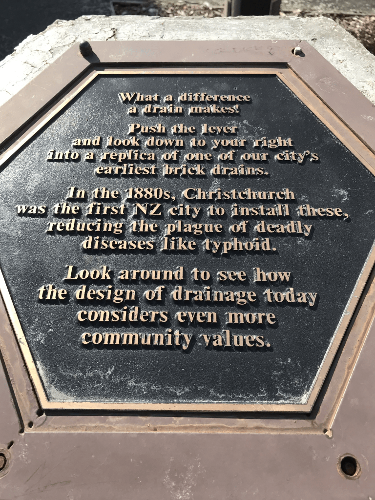
As a change from writing about streets I thought that I would research a drain. An email from the council mentioned Baxter’s Drain so I had to find out about it. A small amount of information from Papers Past. Most entries were from the Drainage Board as early as 1885. An engineer report mentioned a sump to be placed at the exit of the drain at Hazeldean Rd. A couple of months later they said that the drain at Hazeldean Rd needed reconstructing. Must have been a dispute about who was to pay for this as the Sydenham Borough Council said it was under the Drainage Board control. At least one entry from Board of Heath. Note there was a big problem with health issues because of the swampy land that Christchurch was built on. In 1889 there were several objections to the Sydenham Borough Council doing the work on the drain as it should be the Drainage Board’s responsibility. There seemed to be an issue with reconstruction of the culvert at Hazeldean Rd because of the railway line. The same year there were articles about the nuisance arising from slops entering the drain from side channels. Typhoid was a huge problem in the city causing many deaths. In 1896 the cost of doing repair work was mentioned. The drain isn’t mentioned again until 1904 where a concrete invert to be placed in drain between Burke St and Fairfield Ave as diverting it in Ruskin St would be too expensive. Pipes had been laid in Fairfield Ave going through Mr Reeves property. There was a suggestion from someone that the drain should be filled in but obviously that didn’t happen. In 1906 there was a complaint about the drains near the cemetery and an engineer reported that it should be replaced or piped. In 1907 Julia Bennett in Disraeli St stated that if the Drainage Board would cover the concrete invert being laid through her premises she would grant a deed pf easement. The cost of the concrete invert drain from the cemetery to Disraeli St was £58. There were no more entries after 1908 about the drain.
I believe that Christchurch started installing a sewage system in about 1882. I used to own a property that backed onto the cemetery and there were two caveats on the title. One was because of the cemetery and the other was because of this drain. Baxter’s drain was upgraded and reserves established. Several older houses were demolished to create the reserves but I can’t remember the date. I know that it was after 2005 and before 2009. There was a plaque at the Fairfield Ave entrance to the cemetery about the first drain in Christchurch but sadly it was recently stolen. Plaques have been stolen in the cemetery as well. The drain one is especially annoying for me as I have a geocaching lab adventure that used that plaque for one of the questions. I did manage to find a map of Baxter’s Drain but I couldn’t find the map which showed all the drains and waterways under Christchurch. This was annoying as I know that I have previously looked at this map and it was fascinating.
Tainui St in Somerfield – First mentioned in The Press in 1910 when T. W. Jacobs advertises 2 new 4-room houses for sale there.
A tiny amount of information from library website. Note library says it is in Spreydon but property valuation website says it is in Somerfield. Real estate agents say Lower Cashmere.
There were lots of entries on Papers Past as there were several streets with the same name in New Zealand. Lots of death notices plus houses for sale over the years. Cecil William Rudkin a knitting factory foreman was mentioned in 1918 as he was applying for exemption for going to war. The Rudkin family were mentioned a few times on Papers Past and they lived at 11 Tainui St. Trees were planted on the street in 1922 and in 1925 a house and shop was destroyed by fire. In 1912 a large property was available and it had 80 fruit trees on the property. No dramas in this street. I mentioned this street in my write ups about Darley St and Moana St. Part of Tainui St became Moana St in the early 1920s the street is extended. The map for 1930 shows the street as looking like a weird T shape but it now just goes from Somerfield St to Darley St.
I actually walked this street back in January and it is a pleasant tree lined street. Slightly scary as it was a very windy day and a tree branch had fallen onto the footpath. I also chatted to a local who commented about the strong winds and her garden. Most of the houses on the street date from 1910 to 1920. There are newer houses but they are mostly on back sections. When I walked the street there were large red ribbons tied around some of the trees. I did like this street.
Elizabeth St in Riccarton – The section of the street from Wainui Street to Matipo Street was formerly named Rockwood Street. Named after Elizabeth Jane Relph, née Mulcock, (1863- 1934). Elizabeth Mulcock was a daughter of Edward Mulcock (1837-1915), owner of the land where this street was formed. Elizabeth Street is first listed in street directories in 1904. Rockwood Street appears only on maps and not in street directories. Incorporated into Elizabeth Street on 14 May 1923. It still appears on a 1930 map running between Junction Road (Wainui Street) and Matipo Street.
A small amount of information from the library website and there are a couple of mistakes. The section between Wainui St and Matipo St was named Rookwood St and not Rockwood St. A man named Henry Phillip had a property called Rookwood here. I had a thorough look at maps and as early as 1912 Wainui St was called Wainui St. It was also Wainui in 1922 and 1941. Only the map for 1930 has Wainui St as Junction Rd. It isn’t until the map for 1950 that the entire street is called Elizabeth St. Going by maps for 1941 and 1950 there is a new subdivision and Elizabeth St is extended to a new street called Centennial Ave.
There was a huge amount of information on Papers Past as there were so many streets with the same name in New Zealand. There were lots of death notices. Between 1903 and 1910 there were several sections and houses for sale. In 1919 there were several properties for sale after the death of William Fine. William’s name was frequently mentioned in connection with this street and there were members of this family still living in the street in the 1940s and 1950s. William Fine was a contractor and did the shingling of many streets in the area including this street. From about 1950s onwards the Wharenui Pool is mentioned and there is still an entrance to the pool on this street. The Upper Riccarton Methodist Church had a parsonage on the street and it was possibly where there is now a Community Church.
Edward Mulcock might have owned land here but he never lived here. He lived in Flaxton until he retired and moved to the Cashmere Hills.
I actually walked this street in January last year and I remember doing the research but managed to lose the information. I do tend to use scraps of paper. There is about 264 houses here and most are flats. Houses cover most decades and there are still about 6 or 7 houses that date between 1910 and 1920. They are in reasonable condition. A few houses from 1930s and 1940s but the years 1970s and 1990s saw the biggest number of houses until you get to the last 10 years. The last 10 years has seen a huge growth in multi dwelling style of housing. None really stood out for me so there obviously wasn’t too many ugly toilet block houses. In the last two years a cycleway has been formed on this street so in places the street is blocked from cars being able to turn into the street. Parking would be a nightmare if you live on this street.
Quarry Rd in Mt Pleasant – Named after the stone quarry on this site. The St Andrews quarry was owned by Samuel Paul Andrews (1836?-1916), plasterer, politician and businessman. It was on the site of the present-day Mount Pleasant Tennis Courts. Stone was broken with hammers and carted in drays to a chute which led to the stone-crusher on the flat land below. Road metal was supplied to local authorities. Andrews also owned another quarry at the end of Rossmore Terrace. First appears in street directories in 1941.
A reasonable of information from the library website. The quarry was actually called Andrew’s Quarry and not St Andrew’s Quarry.
The earliest entry that I found on Papers Past was in 1944 but I possibly missed a few entries as there were thousands of entries on Papers Past as every town in New Zealand seemed to have a Quarry Rd. A few death notices but most entries involved a court case in 1987. A couple had a house built on the street but had problems with it. It was described as an expensive house and pool complex on a filled hillside side. Soon after it was built the house and pool started cracking and sagging. The architects and engineers had to pay damages of $315,528.00 and the council were criticised as well.
Samuel Paul Andrews was from Isle of Wight and tried several occupations including mining and plastering before becoming a contractor and owning a quarry. He went bankrupt a couple of times which shouldn’t be a surprise as so many streets in Christchurch have been named after businessmen who went bankrupt.
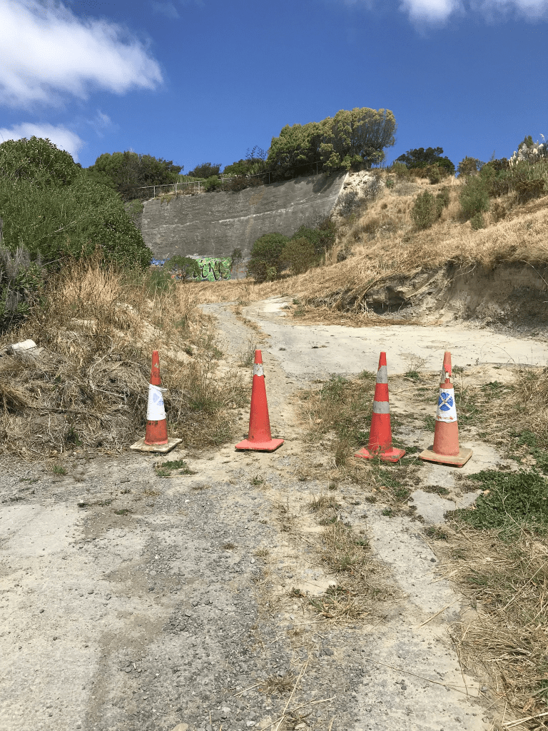
No footpath on this street but there wasn’t any traffic. There is the Mt Pleasant Tennis Club here as well as the King Park and playground. There are only three houses left on this street. They are from 1930, 1950 and 1960. There are at least eight houses that were demolished here including the one that was mentioned in the 1987 court case. Looking at street view from before the earthquakes there were some lovely houses. One looked especially gorgeous and it is sad that it was destroyed in the earthquakes. On one side of the street there is no longer any houses and the land is lower than what is used it be. Two or more of the houses were built on a clay bank and there had been a big retaining wall. Behind the retaining wall was what they called infill and was probably rubble. The bank and retaining wall no longer exist and obviously the houses no longer exist.
Mortens Lane in Mt Pleasant – Named after Richard May Morten (1823- 1909). Morten was a sheep farmer and benefactor of the Anglican Church. He owned the Mount Pleasant run and a quarry on Dyers Pass Road and also Morten’s Block on the south-west side of Cathedral Square. He lived at Stoneycroft, Hornby. First appears in street directories in 1976.
A reasonable of information from the library website. Papers Past had only seven entries about the street and a couple of them were ads for sections in the early 1980s. Lots of information about Richard Morten on Papers Past and he left England for Victoria and Tasmania in 1859 but he was a sheep farmer at Rakaia by 1860. He purchased Mt Pleasant Run and other sheep stations. He had a quarry at Mt Somers and the stone from this quarry was used on many of the buildings in Christchurch including Morten’s Block which was also known as Morten’s Building. This building was sold in 1882 and it eventually became the United Service Hotel.
Only 5 properties on this street and the houses were built in 1940, 1980, 2015 and 2020. One property doesn’t seem to have a house on it. I didn’t actually walk this street as there wasn’t a footpath and it just looked like a driveway to a house. If there hadn’t been a sign with the street name I wouldn’t have known that it was a street.
Marama Crescent in Mt Pleasant and nothing on the library website. I was surprised that there wasn’t any information on the library website as there is one house from 1930 and many from the 1940s and 1950s. Papers Past had a bit of information about the street. There were a couple of death notices in 1949 and 1950 plus an ad for a lost item in 1948. Several ads for the sale of sections in 1950 which included this street. In an article in 1989 about the Cannon Estate and that the land was purchased in by a development group in 1956. Sections were available in the 1960s, 1970s and 1980s. A bach was destroyed by fire in 1959 and this area probably had several baches. I was surprised to come across a name that I knew and it was Fred Sutton. I had always assumed that he lived in Lyttelton but he lived on this street in Mt Pleasant. In the early 1960s he was applying for his real estate agent license.
There are some lovely houses on this street but beyond my budget. One side of the street had the newer houses and they are all rebuilds after the earthquakes. It was a couple of houses from the 1950s that I liked. Great views from this street.
Woodfield Lane in Redwood – The Lane was approved as a name for this right of way in July 2001. However the two parties sharing the right of way were in dispute over this name so it was re-named. Named in 2002.
A small amount of information from the library website and I found information from council minutes about the dispute. The council minutes said the dispute was between the owners of 331 and 333 Main North Road and gave their surnames. I found the owner of 333 Main North Rd and his address eventually because 1 Woodfield Lane. I couldn’t find the details for the other person. Apart from one house built in 1960 the rest were built in 2000. The ones built in 2000 are all exactly the same and there wasn’t a footpath for me to walk on. The houses all back onto Redwood Park. These were big sections that were subdivided.