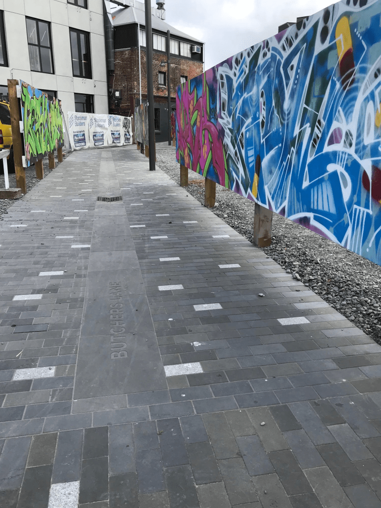
Butchers Lane in the Central City. This lane is a walkway behind Smash Palace on High St and is very new. Found two news articles about it from November 2019 and July 2020 but the owner of the land was in negotiation with the council from 2014. The reason for the name was from the historic Knight’s Butcher Shop that operated here from late 1890s to 1985. Not a lot of information on Papers Past but they were fined in 1903 under the Slaughtering Act. I didn’t research James Knight as there is very good information online if you go to Canterbury Stories NZ and look up James Knight butcher. This area is still being worked on and there is some great street art along this lane. There is also new street art in the High St area and well worth having a walk in the area. There is one downside to the lane and that is men using the nearby bushes as a toilet. No I didn’t need to see that man waving his private parts at the bushes when I was trying to get a photo of street art. Gross.
Dave Jamieson Lane in Hillmorton- Named after Dave Jamieson. Jamieson was one of the most influential horticulturalists involved in the establishment of the gardens at Sunnyside. At his request the name David was changed to Dave, as this is the name he uses. A right-of-way in the second stage of a Ngai Tahu subdivision developed on the site of the former Sunnyside Hospital. Named in 2007.
A reasonable amount of information from the library website. The library website has this street in Middleton but all the surrounding streets are in Hillmorton. I couldn’t find anything online about Dave Jamieson. I didn’t actually walk this street as it was a private lane and I didn’t realise that the buildings were houses as they looked like businesses. Most were built in 2019 with a couple built in 2010. The lane runs off Mokihi Gardens.
Mokihi Gardens in Hillmorton- Named because Wai Mohiki is the Maori name for the upper reaches of the Heathcote River. In the second stage of a Ngāi Tahu Property Group subdivision developed on the site of the former Sunnyside Hospital. Named in 2007
A small amount of information from the library website and my spelling of Mokihi Gardens is the correct spelling. The library website spelling of Mohiki is incorrect. Wai Mokihi is the Maori name for the upper reaches of the Heathcote River and I believe that mokihi means raft made from bundles of flax.
There are 71 houses here and most were built in 2010. There is a couple of entrances to the reserves including the wetlands area from this street. The street is a circle and comes back onto itself when walking it. Considering the name of the street there are very few gardens and just house after house with immaculate lawns. Boring. The houses are built in lots of different styles that are ‘ interesting’ and are probably award winning designs. In other words ugly with one that looked like a fire station plus the usual toilet block style. A couple of nice gardens and one garden had shrubs that looked like they were topiary at one stage. A bit neglected but in google maps they are very clearly shaped birds and animals. There is some nice walking in the area and obviously dog walkers like the area as I managed to stand in some dog shit that was in the middle of the footpath. I couldn’t decide if I liked the street or not.
Seagar Lane in Hillmorton- Named after Edward William Seager (1828- 1922)Seager was a policeman, gaoler and asylum superintendent, being the first superintendent of Sunnyside Hospital. A right-of-way in the second stage of Linden Grove, a Ngāi Tahu subdivision developed on the site of the former Sunnyside Hospital. Named in 2007.
A small amount of information from the library website and there is nothing that I can add about the name of the street. There is lots of information about Edward Seagar online and there are possibly books about him as well.
There is a reserve near this street and there are two entrances to the reserve from the street. One entrance has a set of nice gates. There are 13 houses here and most were built in 2015 and 2016 with a couple built in 2000. Luckily it was a quiet street to walk as there were cars blocking the footpaths even though there was plenty of room to park on the road. All I can say about the houses is that toilet block style dominated here. Another street that I didn’t mean to walk yesterday but I was getting clues for a multi cache.
Pavilion Crescent in Hillmorton – In the first stage of Linden Grove, a Ngāi Tahu subdivision developed on the site of the former Sunnyside Hospital. Named in 2007.
A small amount of information from the library website. The council report about the subdivision only had a list of names to be approved and no reason for the names. I suspect that there was a cricket pavilion here as there are two tiny streets running off Pavilion Crescent called The Oval and The Wickets.
There are only 12 houses here and most were built in 2010 with a couple built in 2000. They all looked exactly the same but there is a nice park nearby called Pavilion Park. I was getting clues for a multi geocache and hadn’t actually planned on walking any streets yesterday as I am behind in researching and writing up streets that I have walked in recent weeks.
Balrudry Street in Avonhead and nothing on the library website. This surprised me as the street had to be an older street as there was a footpath on both sides of the street plus I remember it from my days of working at Avonhead ANZ. Most houses here date from 1950s with one house built in 1940s. There was mention in the late 1950s and early 1960s about a new housing area. Sections were sold by ballot to returned servicemen. The area possibly was originally an orchard but couldn’t find any extra information this apart from an ad about a property for sale. I was amused to see notices about a company called Burbery Finance applying for registration as a money lender in 1961 and 1965. I was also amused by an article about a muscovy duck being found and eventually returned to it’s rightful owner. I don’t think that the duck was happy about being found as it was destined for the cooking pot. I was very surprised to see a death notice in 1970 of someone that I knew as I knew her from Rakaia Huts where she had lived plus owned the wee shop. I couldn’t find the reason for the street’s name but it was possibly a place name. Through an ancestry website I found it mentioned as a place near Dundee in Scotland and also a place north of Dublin in Ireland. Couldn’t find either place on google maps.
At one end of the street there is Ferrier Park and I checked out Claude Jack Ferrier but couldn’t find him living in this area. He did own land here as he donated the land for the park. None of the houses stood out and were typical 1950s houses but one did have a fun garden. The owner overheard me talking to myself as I was saying to myself what a fantastic and interesting garden. She laughed and yes I do occasionally talk to myself.
Flesher Ave in Richmond – Named after the Flesher family. William Flesher (1837-1889) bought 25 acres there for £500 in 1871. His son, James Arthur Flesher (1865-1930), a lawyer, was mayor of New Brighton 1912-1913 and 1915-1917 and mayor of Christchurch 1923-1925. The road was formed out of land that had previously belonged to Avebury House and acknowledged the contribution of the Flesher family to the Richmond community. First appears in street directories in 1943.
A small amount of information from the library website. A few entries on Papers Past which were mostly death notices and a few engagements. The residents seemed to be an accident prone lot and for a fairly small street there were several entries about car accidents and falling off bikes. At least two managed to fall into the river while cycling. There was a policeman who killed his wife and was charged with manslaughter. He was found guilty but his lawyer did his best to say that she died from natural causes and not from his client beating his wife to death.
Some sources say that this street was named after James Flesher and other sources say that the street was named after the family. William Flesher was born in Otley in Yorkshire and his father died young. William died on board the ship Tarawera travelling between Melbourne and Hobart and he was only 52. It does sound like he had heart issues. His son James was a barrister and solicitor who died aged 65. His son Hubert sold the house and land to the crown and the area was called Flesher’s Block.
There are now only 18 houses here and most are built in the 1940s and have the typical state house look about there. There were a lot more houses here before the earthquakes but most have been demolished. The side of the road closest to the river is now a wide green space and I assume is in the red zone. I looked at google maps from just after the earthquakes and the road was a mess.
Note Avebury House was named after Avebury in England which is a favourite place of mine.
Eveleyn Couzins Ave in Richmond – Named after Eveleyn Charlotte Couzins (1896- 1945). Miss Couzins was a niece of Sir Ernest Andrews, the mayor of Christchurch 1941- 1945. She acted as his mayoress and the street was named after her at his request. The street was formed on land that had previously belonged to Avebury House. In a government housing subdivision. Named in 1945. First appears in street directories in 1950
A reasonable amount of information from the library website. Papers Past had a little bit of information about the street and a lot of information about the Eveleyn Couzins Memorial Fund. In the 1950s someone was selling Christmas trees every December and there was a dressmaker living on the street. In 1967 the building housing the Plunket Rooms became the Cora Wilding Youth Hostel and it could sleep 28 people. It closed as a Youth Hostel in the 1990s. The Cora Wilding Youth Hostel was in Avebury House and Avebury House originally belonged to the Flesher family. This building was built in 1882.
The small reserve was named Avebury Park in 1948 and in 1956 there were plans for flats for aged pensioners. My favourite headline from 1961 was Small car dives into Avon.
Avebury House is a gorgeous building and thankfully has been saved from being demolished. There are still a few houses from 1940s on this street and they have the typical State House look about them. There is a huge number of apartments built in 2018 and 2019 and they are possibly social housing but not sure.
At the River Rd end there is a lovely community garden and when I checked google maps from before the earthquakes there was a huge house on a fairly large section on this corner. Many of the original State Houses have been demolished and this is now a green space. The Avebury Park had a playground and when I walked here last Sunday evening it was being used by at least two or more family groups. I actually am not sure if I would like to live on this street as two or three of the houses looked very rundown but I do like Avebury House and I did like the community garden.
Kershaw Place in Richmond – Developed in a subdivision of the Flesher’s block, Richmond. First mentioned in The Press in 1944. First appears in street directories in 1946.
A tiny amount of information from the library website. Not much information in Papers Past and it was mostly death notices. This area was developed in 1940s for Housing dept and the houses here are all built in typical State Housing styles. I suspect that the street was named after Mark Kershaw a city councillor who died in 1943. Mark Kershaw lived in the Linwood area and was active in the community. He was a district health inspector until his retirement in 1935 and became a city councillor in 1941.
Aldersley Street in Richmond – Named after Philip Atkinson Aldersley (1883?-1963). Aldersley ran a bakery business in Richmond in the 1940s and 1950s. He lived at 17 Chrystall Street. In a government housing settlement off North Parade. When the street was named after Aldersley, he gave the Mayor, E. H. Andrews, £5 for the first baby to be born to residents of the street. Named in 1941. First appears in street directories in 1943.
A small amount of information from the library website. Not many entries on Papers Past and in April 1943 there is mention of a family having a baby and qualifying for the £5 but no more details. A complaint about the state of the street in 1945 but council reply was that it was the Housing dept responsible for the street and not the council. There was a death notice in 1967 for a Douglas Kershaw and there is a nearby street called Kershaw Place. Philip owned a bakery on Stanmore Rd and the electoral rolls show him as living on Stanmore Rd until 1928. From 1931 onwards he lived at 17 Chrystal St with his son and daughter. Sadly his wife died in 1930 aged 56. Philip was born in 1882 in Croydon and I didn’t found the date but he came out to New Zealand with his parents.
Most the houses here date from 1940s and are the original Housing dept houses and are built in the typical State Housing style of the 1940s. One has been altered and looks different to the original house and many of the houses are now privately owned. There is a group of flats built in 2017 and these look like social housing. The street runs off Flesher Avenue.