Ernlea Terrace in the suburb of Cashmere, Christchurch

Ernlea Terrace – Named after Leonard Ernle Clark (1906- 1964). Clark’s middle name is pronounced Ernlee so the “a” may have been added to ensure his name was pronounced correctly

Very little information on the library website for a street named after an interesting person. The Terrace is named after a man dubbed the forgotten flyer. He was a pilot and was the second person to fly solo from England to NZ and only one of 5 people to fly solo from Australia to NZ. His nickname was the Flying Farmer. He learnt to fly at the Canterbury Aero Club and when he was in England purchased a Percival Gull so that he could fly home for the shearing season. He was a pilot in the Royal Air Force in World War Two.
At the end of this street there is a reserve called Ernle Clark Reserve and it was a pleasant walk here today in the shade of trees as it was such a hot day.
There is a property on this street that sells water to Christchurch people who object to our chlorinated water. The house on this property is fantastic. It is a tiny street with lovely large houses and even the two modern houses are interesting. In the reserve there are signs warning people to stay away from the swans as the swans bite. It is ages since I have walked here.

Wherstead Road in the suburb of Cashmere, Christchurch

Wherstead Road -Probably named after Wherstead, a village in Suffolk, England.

This was a street of mostly lovely old houses but wasn’t possible to take photos. Near the playground there were two very modern ugly houses. This is a posh and expensive area. Very little information on the library website. It is likely that an early settler would have come from the Suffolk area.

Lewis Street in the suburb of Hoon Hay, Christchurch

Lewis Street – Named after the Lewis family. David Lewis (1825- 1874), of Halswell House, arrived in Canterbury in the 1850s. His son, Charles Lewis (1857-1927), was a member of the House of Representatives and also parliamentary whip. He farmed at Halswell where he bred Shropshire cattle.

The library website had a long blurp for a very short uninteresting street. A more modern area of town probably from the 1960s to 1970s. There are a few shops here but the only reason I did this street yesterday was because I needed a geocache for a souvenir. David Lewis is buried at Barbadoes St Cemetery

Brougham Street in the suburb of Addington/ Sydenham in Christchurch

Brougham St – formerly Going’s Road and Pound Road, Lord Brougham Street and Lord St Leonards Street. Sydenham Crescent Road and South Crescent Road were incorporated into Brougham Street. . Named after Henry Peter Brougham, 1st Baron Brougham and Vaux (1778- 1868). Going’s Road was the section of road east of Colombo Road through to Gasworks Road (later Waltham Road). First mentioned in the Star in 1877 in a report of a meeting of the Heathcote Road Board. Pound Road was the section of what is now Brougham Street west from Colombo Road to Montreal Street. Named after the animal pound there. Lord Brougham Street (section east of Colombo Road) and Lord St Leonards Street (section west of Colombo Road) are both first mentioned in the Star in reports of meetings of the Drainage Board held 1882. Lord St Leonards Street was probably named after St Leonards in Sussex. Re-named Brougham Street in 1889. Brougham was a British lawyer and politician who became Lord Chancellor. Sydenham Crescent Road was re-named South Crescent Road on 7 March 1904 and was later incorporated into Brougham Street.

A huge amount of information from the library website. This is a very long street and is now a major thoroughfare. The road carries a large number of trucks as it goes from the Southern Motorway and joins Opawa Rd leading to the business area in Hillborough and also many trucks go to Lyttelton.
At the Opawa St end I had to take a short detour as there is no footpath. I am then able to use a walkway that eventually joins a footpath. On one side there is mostly businesses and on the other side there are a few houses. There is 2 or 3 blocks of empty land where there used to be a large number of social housing flats. These were badly damaged in the earthquakes.
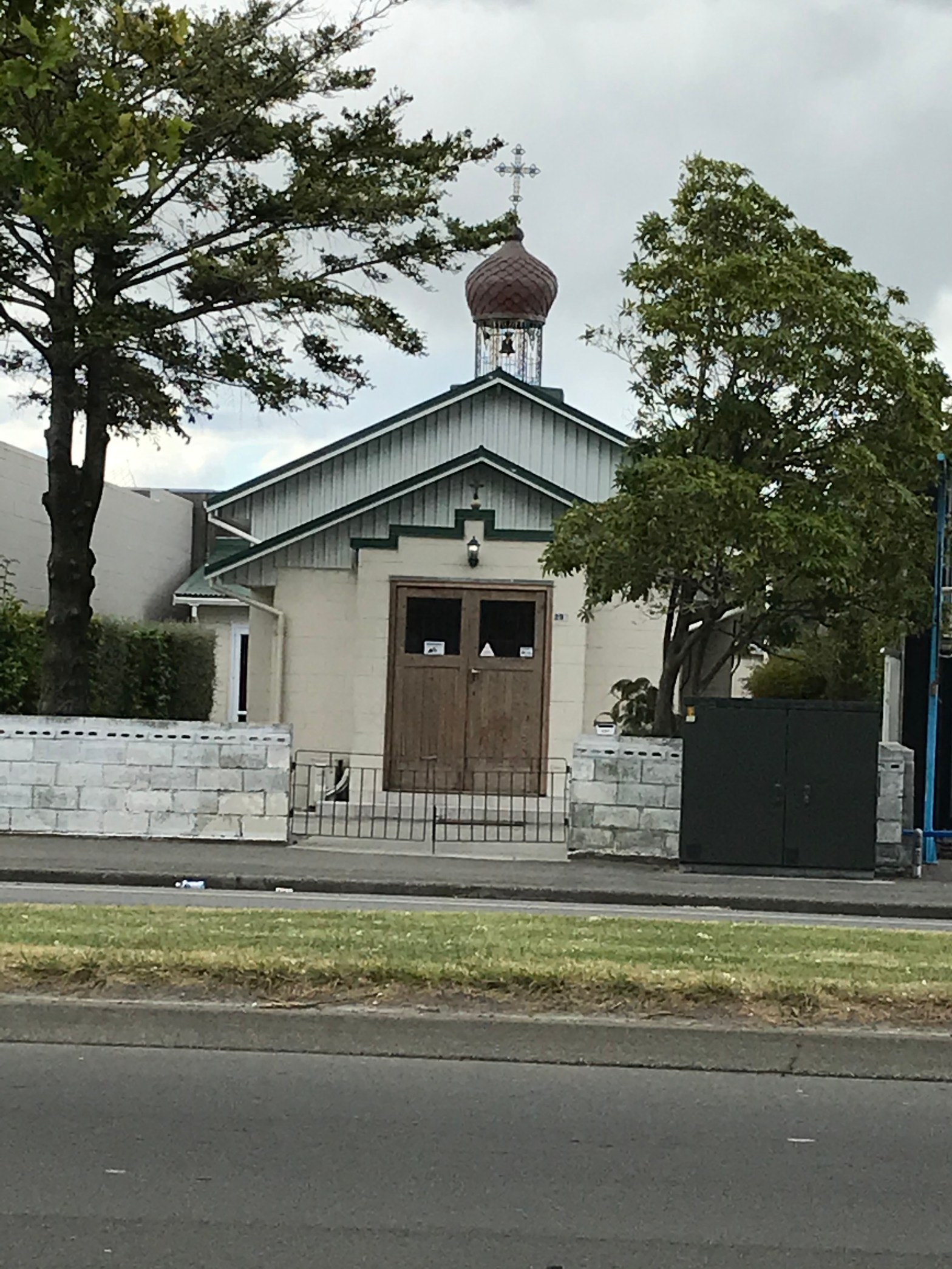
This street covers three suburbs.In the Sydenham area there are still businesses on one side with a couple of exceptions. One is a tiny church called St Nicholas Rocor Orthodox church and the other is a set brand new apartment complex. The apartments are brightly coloured but everyone I have spoken with agree that these apartments don’t look safe.
Sydenham Park is in this area. Opposite the park is a pile of rubble that used to be a church. This church was demolished by mistake as it was the old Post Office on the other side of Colombo St that supposed to have been demolished. As I get closer to home there are less businesses and more houses.
There is a large retirement complex which is fairly new and this replaced an old historic building. It is still called Nazareth House and google research says that it started as an orphanage in the early 1900s and became a rest home later. I had an ancestor die at Nazareth House in 1913.
As you get closer to the motorway it is mostly housing but there is Addington school on one side and the Samoan Addington Seventh Day Adventist church on the other side of the road.

With further research I found an article in Papers Past dated 1882 and it was about drainage issue. It was asking if Lord Brougham St was synonymous with Going’s Road and the reply was yes. Going’s Road was mentioned as early as 1875. On an Ancestry website I found William Going who came out in 1855 with his family. There were two sons Thomas and George who were farming in South Christchurch in the 1850s and 1860s. I suspect that Going’s Road was named after this family.

Hazeldean Road in the suburb of Addington in Christchurch

 Hazeldean Road – First mentioned in the Star in 1873. First appears in street directories in 1878. Not much information from the library website.This is a street in the industrial area of Addington and most of the businesses seem to be connected to the auto industry.

A small amount of information on the library website, With further research on Papers Past the first mention is in 1873 when someone was fined for having cows on the road.Lots of ads for sale of land and cottages in 1870s and 1880s. In 1875 it was requested that the council look at a footpath for the road. In 1878 a woman was charged with keeping a low brothel. This amused me as I now want to know if there are high brothels. In 1879 there were three ads from a A H Harts of Hazeldean Cottage. In 1900 there was an article about an Engineers Band Room on this street. A big article in 1937 about land needed for new railway station and that all the houses on Hazeldean Road will be demolished. The houses were described as being red brick terraced houses. By the 1940s there seemed to be only ads for car sales and other similar businesses. Couldn’t find anyone with the name of Hazeldean in cemetery records apart from a baby. There was at least one person with the surname Hazeldean living in Christchurch in this period but he was living on Tuam St.

Church Square in the suburb of Addington in Christchurch

Church Square – surrounds St Mary’s Church. Not a lot of information on the library website. There is a well used cycleway that goes through Church Square. There is a mixture of new and old houses in the square and most are in a good condition. The square is close to the Salvation Army Hostel and many of the ‘clients’ like to hang around in the church grounds. It is a lovely wooden church and the historic bell-tower is one of my favourite buildings and it is dedicated to the memory of Richard John Seddon. The lych gate is a memorial to local WWI casualties. The drop in centre Manuka Cottage since the earthquakes uses the church as their premises. The church started out as a small room in 1867 but was gradually enlarged until you get the current building. If you want more information about the church you can google St Mary the Virgin in Addington. I do have a geocache hidden here.

Show Place in the suburb of Addington in Christchurch

Show Place – Named after the neighbouring Addington Show Grounds. The Show Grounds were closed in 1996. Show Place was “devised by property developer Ernie Henshaw as a precinct of high specification, energy-efficient buildings aimed mainly at multinationals”. Formed post-1997

As the library website states this is a street designed for businesses. There are insurance companies, IT businesses and one bank here plus many others. There was also a gym with an attached restaurant. The buildings are modern and I couldn’t really tell which ones were pre-earthquake and post earthquake. One was obvious as it was having work being done on it. The area was nicely landscaped with a decent path for walking. I was pleasantly surprised by this street.
A nice wee water feature and I also found a painted rock under a tree.

Barrie Street in the suburb of Addington in Christchurch

Barrie Street – Formerly Jubilee Street. Named to commemorate the Golden Jubilee of HM Queen Victoria (1819-1901), celebrated in 1887. Re-named Barrie Street. Named after James Matthew Barrie (1860-1937). Jubilee Street is first mentioned in the Star in 1888: a birth notice for a child whose parents lived in Jubilee Street, Addington. Re-named Barrie Street by the Sydenham Borough Council in 1889. Barrie was the author of Peter Pan. Probably continues the theme of “poets and writers” streets of Sydenham, Addington and Waltham.

A reasonable amount of information on the library website.

Nearly 18 years years ago I tried to buy a place on this street but sadly it had a faulty title and the bank wouldn’t lend the money. In hindsight that was a good decision. I like the artwork on this street which relates to Peter Pan. I so want to hide a cache here but can’t find a suitable hiding place.

Kipling Street in the suburb of Addington in Christchurch

Kipling Street – Formerly Mansfield Street. Named after Kate Hickman Peacock, née Mansfield, (1835?-1894). Re-named Hawkesbury Street. Named after the Hawkesbury district in NSW, Australia. Re-named Kipling Street. Named after Rudyard Kipling (1865-1936) Kate Peacock was the first wife of the Hon. John Thomas Peacock (1827-1905). Mansfield Street was developed through his property and named in 1899. Re-named Hawkesbury Street the same year, when the street was officially formed by the Sydenham Borough Council. Peacock was born in the Hawkesbury district, New South Wales. Re-named Kipling Street in 1909. Kipling was an author and Nobel Laureate in Literature in 1907. He visited Christchurch in 1891, calling in at Coker’s Hotel. Probably re-named to continue the theme of “poets and writers” streets of Sydenham, Addington and Waltham

A lot of information from the library website. I often walk this street because of Pokemon Go. I didn’t realise that it had had so many name changes. It is a mixture of old and new houses. I do have a better photo but I quite like this one.

Disraeli Street in the suburb of Addington in Christchurch

Disraeli Street – Named after Benjamin Disraeli (1804-1881). Disraeli was the Prime Minister of Great Britain 1868 and 1874-1880. One of the “poets and writers” streets of Sydenham, Addington and Waltham.

A small amount of information from the library website. I walk part of this street on a daily basis and not only because there 4 Poke Stops for Pokemon Go on the street. Walking the full street this morning I discovered an interesting shop called Junk and Disorderly. Might have to go back for a visit. This street has businesses plus housing. Most of the houses are in a well-kept condition.
This street has the Addington Angels plus some street art so I quite like the street. There is a plaque to Disraeli in the reserve.