Claxton Place – First appears in street directories in 1957.
A tiny amount of information from the library website. I couldn’t find anything extra to add to this. Claxton sounds like someone’s surname and the only person that I could find lived over New Brighton way. This street runs off Riverlaw Tce
Mostly brick houses built in the 1960s but as with the rest of this area there were a couple of rebuilds. Footpath on both side of the street which I like. Nothing stood out for me here.No photos.
Derrett Place in the suburb of St Martins, Christchurch
Derrett Place – Named after Selwyn Noel Ellison Derrett (b. 1908) and his wife, Valarie Zoraide Evelyn Derrett (1916- 1991). Derrett was farming at 200 Fifield Terrace in 1950 and his wife was running the Wharema Convalescent Home in Opawa. The street was formed on a subdivision of their land. First appears in street directories in 1950.
A small amount of information from the library website. Selwyn Derrett and his wife did live on Fifield Tce but Derrett Tce runs off Riverlaw Tce. If their property on Fifield Tce was subdivided to form a street surely it would run off Fifield Tce. The Heathcote River divides Riverlaw Tce and Fifield Tce. A bit confusing..
Selwyn was born in 1908 and seems to be known as Noel Derrett. He died in 1986 at Oxford. They were married in 1942 but possibly divorced in the 1950s.
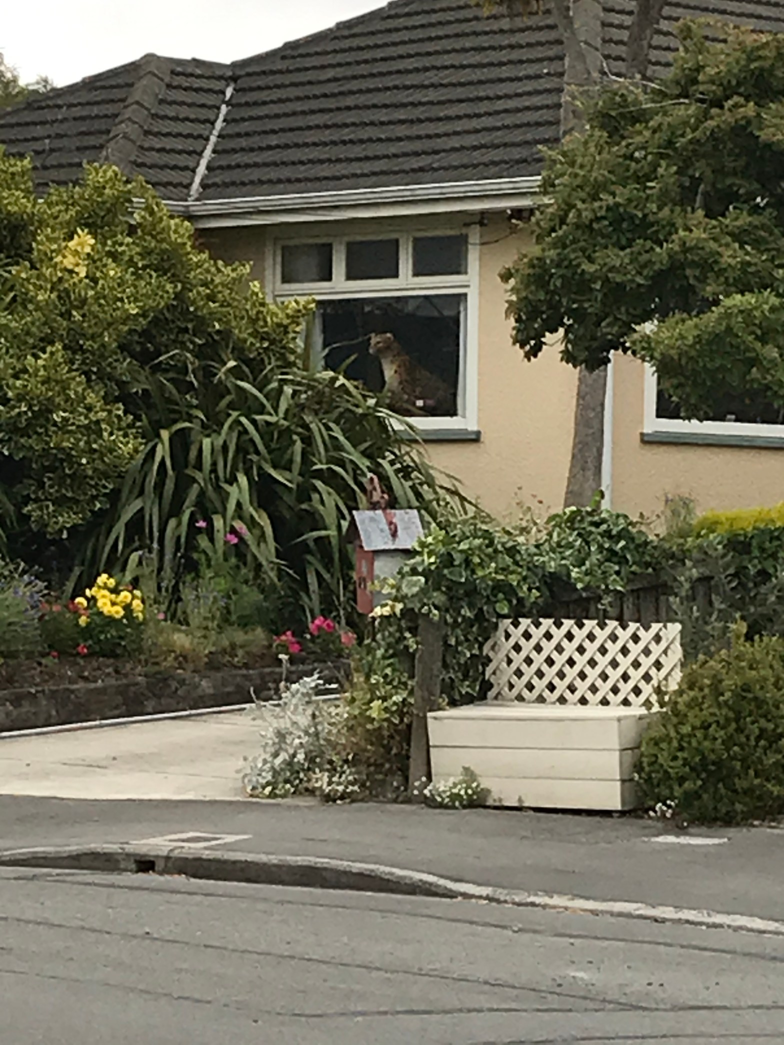
The houses here date from 1950s but there are rebuilds here. At the end of the cul de sac there is a house being rebuilt and it looks like it is going to be huge. I was amused by a “giant cat” in someone’s window. Footpaths on both sides of the street and it looked like a nice street.
Fifield Terrace in the suburb of Opawa, Christchurch
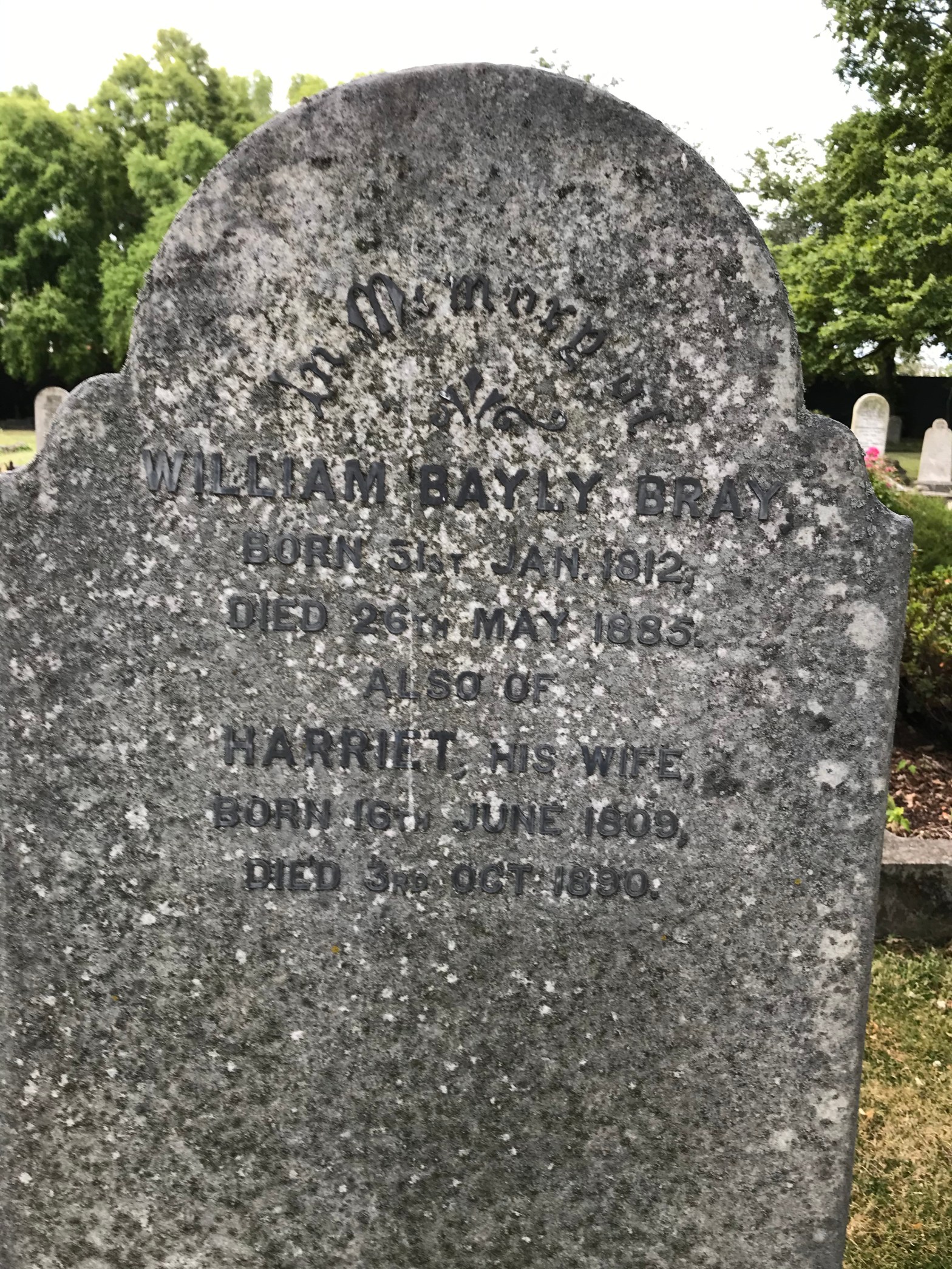
Fifield Terrace – Formerly River road. Named because it runs along the northern side of the River Heathcote between Wilson’s Bridge and the Railway. Re-named Fifield Terrace. Named after Fifield, the home of William Bayley Bray (1812?-1885). Bray was consulting engineer to the Canterbury Provincial Council. An advertisement for a general servant for “a family up country” appears in the Star in 1880. Mrs Bray, Fifield, Opawa, “near railway station” is the advertiser. Re-named in 1917. First appears in street directories in 1924.
A reasonable amount of information from the library website. Article in Papers Past said that there were too many River Roads which was confusing which is why this one was renamed Fifield Tce. Sounds like William Bray was an interesting man and he was described as eccentric in his obituary. William was an engineer and worked with Moorhouse on the Railway Tunnel. There was a story about William being mocked for his views on the risk of the Waimakariri River flooding Christchurch as he wanted flood protection barriers built. They weren’t laughing after the big flood of 1868 when he was proved correct.He died of pleurisy on 26th May 1885.
William and his wife Harriet are buried at Rutherford cemetery and on the headstone it has his birth date as 31/01/1812.
I walked this street last night and it has the Heathcote River one side and houses on the other side. Yes there was a geocache nearby. The houses are on the high side of the river. Houses are a mixture of old and new. Still a few empty sections where houses have been demolished. A wide variety of building materials have been used. A couple of houses I couldn’t tell if they were original cottages or rebuilt in the original style. One house had the most wonderful little playhouse for children and I wish I could have got a photo of it. When I was a little girl it would have been my dream to have a playhouse like this. The children at this property were having a great time playing.
Some of the new houses were huge and I would love to know what the original houses looked like as I suspect that there would have been lovely old villas here.
Esher Place in the suburb of St Martins, Christchurch
Esher Place – Named on 22 March 1971. First appears in street directories in 1977.
A small amount of information from the library website. I couldn’t find any extra information. Couldn’t find anyone with that surname in Christchurch. Houses are from the 1970s. There is a town in Surrey with that name.
This tiny street runs off Riverlaw Tce and it has footpaths on both sides of the street which is always a plus. Pity I was forced onto the road thanks to vehicles blocking the footpath. Nothing stood out for me here. Seemed to be mostly brick houses and mostly a couple of rebuilds but it is sometimes difficult to tell. No photos.
Vega Place in the Heathcote Valley, Christchurch
Vega Place – First appears in street directories in 1987.
Not much information from the library website. The houses here were built in the 1990s and the tiny street runs off Port Hills Rd almost opposite the French Bakery. At the end of the street is a plant nursery. Ended up chatting to a local and she has lived in Heathcote all her life and said it has changed a lot in her lifetime.
It must get very noisy with all the heavy trucks going pass on Port Hills Rd. Vega is a Spanish word for dweller in the meadow or fertile place. As this street backs onto Horotane Valley it is a good name for the street.
The Tors in the Heathcote Valley, Christchurch
The Tors – Named after the cluster of high rocks behind Castle Rock. Developed at 118 Port Hills Road by Horncastle Homes. Named in 2006.
Small amount of information from the library website. I didn’t actually walk this tiny street as it looked more like a driveway rather that a street. A modern street in Heathcote with modern houses.
A bit of googling shows that people are still rock climbing on the Tors after which this street was named. Much of the information on-line about the rock climbing was provided by two people that I know. Obviously lots of rockfalls here after the earthquakes.
Stedley Place in the Heathcote Valley, Christchurch
Stedley Place – Named after Stedley Scott. Scott was a draughtsman employed by the Heathcote County Council. First appears in street directories in 1980.
A small amount of information from the library website. The houses were quite nice here and the footpath was on both sides of the street. I only took one photo of what looked like an older house but after googling I found out that it was built in the 1980s. I did like this house.
Station Road in the Heathcote Valley, Christchurch
Station Rd – Short Road/Short Street was incorporated into Station Street. Named because it led to the Heathcote Railway Station. Station Road is first mentioned in the Star in 1873 in a report of a meeting of the Heathcote Road Board. First appears in street directories in 1903. Short Road first appears in street directories in 1902. Becomes Short Street in 1924. Incorporated into Station Road in 1950.
A reasonable amount of information from the library website. I found the same article dated 1873 on Papers Past. Station Rd was a very common name.There were older wooden villas on one side of the street and the railway line on the other side. There is a great little shop called Heathcote Valley Gallery here but thankfully it wasn’t open as I suspect I would overspend here. There would have been a railway station here but I don’t know when it was demolished. Passengers trains stopped running a long time ago. I used to travel on the school train from Lyttelton to Christchurch but just can’t remember what the station looked like. I have a vision of a wooden building with a verandah style of shelter. It is possible had a really nice garden area as there were articles in Papers Past about the wonderful roses in the station’s garden. If anyone remembers the railway station you can correct me.
Romar Lane in the Heathcote Valley, Christchurch
Romar Lane – Named after the developer’s wife’s parents, Ron and Margaret. A small private right-of way serving 10 properties. Developed at 110 Port Hills Road by Texco Developments Ltd in 2006.
A small amount of information from the library website. A modern street in Heathcote with modern houses which ends at a grassy area and the railway line. The best thing on this street was someone’s campervan. It had Adventure before Dementia on it.
Pawaho Place in Heathcote Valley, Christchurch
Pawaho Place – Pawaho is another form of the Māori name for the Heathcote River. The Pawaho Hamlet or Settlement was a government village settlement of 50 acres designed for workmen with jobs in Lyttelton. First appears in street directories in 1978.
A small amount of information from the library website. This tiny street only had a footpath on one side which was blocked by cars parked on it. There was one house that looked brand new and it is likely to be a rebuild. The other houses were mostly brick and very average looking.
