Ambleside Drive in the suburb of Burnside, Christchurch

Ambleside Drive in Burnside – Formed on land owned by Professor Albert Hugh Flay (1905-1973) and developed by his son. First appears in street directories in 1964. Information supplied in

2009 by Peter Foster in an interview with Margaret Harper.

A small amount of information from the library website and I am not convinced that their information is correct. I have spent all evening on this street and I have searched ancestry website, Papers Past and several old maps of Christchurch.

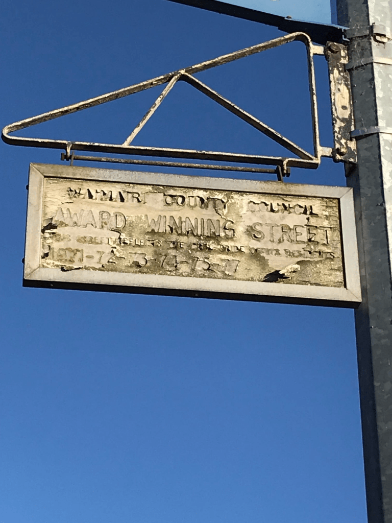
I suspect that there was three separate developments on this street. The first subdivision was in 1962 and it was called Memorial Ave subdivision and was a Maurice Carter project. Maurice Carter seemed to specialise in Crown Land developments. In the 1960s and 1970s the street was winning best street awards and there is a plaque hanging from a lamp post at the Kendal Ave end of the street. In 1970 in the best street competition the street was described as a cul de sac.

In 1971 there was another subdivision called Witbrock Park subdivision and as I am writing this I realise it is highly likely that the Park part is actually a surname. All the houses at the Kendal Ave end of the street were built in the 1960s and were part of the Maurice Carter subdivision. The houses in the middle part of the street were built in 1970s and there is a map on Papers Past showing this subdivision and it clearly shows the area of Ambleside Drive from about Ashbourne St to just past Witbrock Crescent. Witbrock Crescent is included in this subdivision.

The rest of the houses were built in 1980s and are at the Grahams Rd end of the street and that possibly was Albert Flay’s land. This would also fit in with the addresses of Albert Flay and Mabel Witbrock going by the electoral rolls. The development in the 1980s would mean that the street goes from Kendal Ave to Grahams Rd and is no longer a cul de sac.

Are you confused yet? Mabel Witbrock is the person that I found most interesting as she was a sheep farmer. Sounds like she had several properties as both Amberley and Dunsandel were mentioned when she was selling sheep plus she had rental properties in the central city.

There were many different styles of houses but none really stood out for me. Another tree lined street and the trees are starting to show their autumn colours.

Edited to say that the name of the street is obviously from Ambleside in the UK which is a gorgeous part of the UK.

Gregan Crescent in the suburb of Burnside, Christchurch

Gregan Crescent in Burnside – Named after the Gregan family.Bernard Daniel Gregan (1910-1976) farmed at 341 Wairakei Road. The farm extended from Grahams Road to the shingle pits at Lake Bryndwr. The land was bought by the Government for state housing in 1956. First appears in street directories in 1960. Information supplied in 2007 by Bernice Gregan in an interview with Margaret Harper.

A small amount of information from the library website and nothing that I can add about the name of the street. The houses here were built in 1950s and nothing really stood out for me. In 1960s there were a few ads for the sale of houses and some were described as freehold and others described as crown lease. Not a lot of information on Papers Past but I starting to wonder about the residents being accident prone as so many seemed to be reported as hurt in car accidents. A tree lined street that has a walkway through to Kendal Ave. The houses on one side of the crescent back onto Waimairi Cemetery. The street seemed pleasant enough but for some reason I didn’t particularly like it. Weird. It runs from Grahams Rd and circles back to Grahams Rd.

Ashbourne Street in the suburb of Burnside, Christchurch

Ashbourne Street in Burnside – Named after Ashbourne in Derbyshire, England. About 1963 Waimairi County Council minuted a policy that all its streets be named after English place names.

In a subdivision by Maurice F. Carter Ltd. First appears in street directories in 1966. Information supplied in 2008 by Maurice Carter (d. 2011) in an interview with Margaret Harper.

A small amount of information from the library website and nothing that I can add about the name. Most houses built in the 1960s with a couple built in 2019. There was an ad in 1962 about sections and houses for sale in the Memorial Ave subdivision. Also mentioned that the area was the highest and driest in Christchurch. I was amused to see an ad from 1967 for a house being sold and it was described as being in Fendalton North. Locals will understand my amusement. Instead of saying typical 1960s style I probably should start describing the houses as typical Maurice Carter houses. Looked like a pleasant street with nice gardens. A few houses had been updated and looked a bit more modern. The street is tree lined and I really had to watch where I was walking as the tree roots had really damaged the footpath in many places.

Kingsgate Place in the suburb of Burnside, Christchurch

Kingsgate Place in Burnside and nothing on library website. It is amazing how many streets in this area aren’t on the library website yet all the houses date from 1960s. I couldn’t find much information on Papers Past unless you want to know how many times MED were turning off the power for maintenance. As the Waimairi Council at the time had a policy of naming streets after places in the UK it is highly likely this is a reason for the name. I have a vision of the planning committee throwing darts at a map of the UK and picking the names from where the dart landed. This tiny street runs off Ashbourne St and it seemed pleasant enough but nothing stood out for me. Typical brick 1960s style and I am being to think that Maurice Carter the developer only had one house plan for everything he built.

Sevenoaks Drive in the suburb of Bryndwr, Christchurch

Sevenoaks Drive in Bryndwr – Developed by Maurice R. Carter Ltd. The Waimairi County Council was given extra land for the widening of the berms on the bend of the street. Seven oaks were planted there to commemorate the name of the street. First appears as Seven Oaks Drive in street directories in 1962. Becomes Sevenoaks Drive in 1970. Information supplied in 2008 by Maurice Carter (d. 2011) in an interview with Margaret Harper

A small amount of information from the library website and the street would have been named after Seven Oaks in the UK. The oak trees planted are still there. I am pleased that the library explains the wide berm on part of the street. I drive this street frequently enough to have always wondered about it. I always take extreme care when driving here because of the bends in the road and sometimes can’t see a vehicle coming towards you. If vehicles are parked on both sides of the road it doesn’t leave much room.

Apart from a couple of houses from 1970 and 1990 most houses were built in 1960s. Most are typical brick houses of the 1960s with a few that have been updated. Another tree lined street and some really nice gardens here. A pleasant looking street that I quite liked.

Springbank Street in the suburb of Bryndwr, Christchurch

Springbank Street in Bryndwr – Blogg Brothers built “half of the streets in the Wairarapa riding including Kendal Avenue and Springbank Street”. Maurice F. Carter Ltd also built houses there. Carter is listed in street directories of 1962 living in Wairakei Road near its intersection with Springbank Street. First appears in street directories in 1960. Information supplied in 2008 by Bede Cosgriff (d. 2011) and Maurice Carter (d. 2011) in interviews with Margaret Harper.

A small amount of information from the library website. There was nothing on Papers Past about Blogg Brothers building any houses on Springbank Street. In 1958 there were 46 sections offered for sale by Maurice Carter. In 1959 Maurice Carter applied to build a shopping centre at corner of Wairakei Rd and Springbank St. There are 44 houses here and most were built in 1950s. Couldn’t find a reason for the name but possibly a place name in the UK. It is a tree lined street and in many places the tree roots were damaging the footpath. None of the houses stood out but there were some lovely gardens. There is still a shopping centre at the Wairakei Rd end.

Edited to say that I have found out the reason for the name of this street. Springbank was the name of the property where Douglas Graham lived. Grahams Rd is named after Douglas Graham

Sandringham Place in the suburb of Bryndwr, Christchurch

Sandringham Place in Bryndwr – Named after Sandringham in Norfolk, England. About 1963 Waimairi County Council minuted a policy that all its streets be named after English place names.

In a subdivision developed by Maurice F. Carter Ltd. First appears in street directories in 1962. Information supplied in 2008 by Maurice Carter (d. 2011) in an interview with Margaret Harper.

A small amount of information from the library website and not a lot that I can add to it.

All houses on the street were built in 1960s and Papers Past didn’t have much information. The street had a few entries in best street competitions in 1960s and it was also mentioned in the 1962 article about taking a Sunday Drive. The houses were typical 1960s houses but most had lovely gardens. It is a tree lined street with a walkway through to Sevenoaks Drive. I quite liked this street and one house had a cute letterbox that looked like a dog

Derwent Street in the suburb of Bryndwr, Christchurch

Derwent Street in Bryndwr – Named after the River Derwent, Cumbria. About 1963 Waimairi County Council minuted a policy that all its streets be named after English place names. In a subdivision by Maurice F. Carter Ltd. First appears in street directories in 1962. Information supplied in 2008 by Maurice Carter (d. 2011) in an interview with Margaret Harper.

A small amount of information from the library website and nothing that I can add about the name except that is is a lovely part of the UK.

Most houses were built in 1960s and are made of brick. Papers Past had ads for the sale of sections in 1960s. The street had entries in the best street competitions in the 1960s and in 1962 there was an article headed Take a Sunday Drive. It was promoting the streets in this area and the gardens of the houses. There is a reserve on this street and in 1960 the scouts had permission to place two old US army huts on the reserve. Because of protests and complaints from the residents the council put a time limit of three years for the huts to be in the reserve.

It was a pleasant street with nice and tidy houses and I quickly found a geocache in the reserve.

Glencoe Street in the suburb of Burnside, Christchurch

Glencoe Street in Burnside – nothing on library website which surprised me as the houses were built in the 1960s and there is a mention in Papers Past as early as 1960. Papers Past mentions this area including this street as being sold off by Lands and Survey Dept and is a subdivision being developed by the Housing Division of the MOW. I suspect that the street is named after Glencoe in Scotland and I loved my stay in the YHA in Glencoe.

Another pleasant tree lined street with some nice gardens. There was a fence that I liked as it was made out of driftwood. At the end of the street there is a walkway through to Ambleside Drive.

Banbury Street in the suburb of Burnside, Christchurch

Banbury Street in Burnside- nothing on library website which surprised me as most houses were built in 1960s. It was probably named after Banbury in the UK. Papers Past had an ad in 1961 about Crown Land for sale which included this street and the surrounding streets. In 1968 there was an article about a Mr Berry setting up a studio called Banbury Recording behind his house on this street. It was for a Christian Radio Station.

It seemed like a pleasant tree lined street and there were some nice gardens. There was one more modern house built in 1990.