Sheppard Place in the suburb of St Albans, Christchurch

Sheppard Place in St Albans – formerly School Road and School Place. Named because it leads to St Albans School. Re-named Sheppard Place. Named after Katherine “Kate” Wilson Sheppard (1847-1934)School Road first appears in street directories in 1894. Becomes School Place. Re-named Sheppard Place on 1 September 1948 when 120 streets were re-named. Kate Sheppard was a suffragist, social reformer and writer.

A small amount of information from the library website and nothing that I can add about the name of the street. I was in the area geocaching and this tiny street runs from English Park to Trafalgar St. St Albans School and English Park take up most of the street. Most entries on Papers Past are for games at English Park or for the school. In 1925 there was a complaint about people attending games at English Park damaging the school grounds. There was also a School lane in Riccarton which will explain the name change in 1948. The earliest mention that I could find for the school was in 1866 but the school at that stage was on a different site. The best information about the school was from the centenary in 1973. The school was actually established in 1859 but was a private school called St Albans Wesleyan School. It became a public school in 1873 and moved to the current site in 1874. A few entries in 1956 about building a school hall.

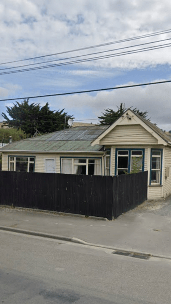
Only 4 houses on the street and the oldest is from 1905 and another is from 1910. The other two are from1985 and 2000. Personally I wouldn’t like to live here because of the park and the school. I suspect that when there are games on at English Park that traffic would be a nightmare even with the yellow no parking lines.

Merlewood Avenue in the suburb of Cashmere, Christchurch

Merlewood Ave in Cashmere – Named after Merlewood, the home built on Cracroft Terrace in 1903 belonging to Dr. John Christopher Bradshaw (1876- 1950).Dr Bradshaw was the first professor of music at Canterbury College 1937-1941. He was organist and choirmaster at Christchurch Cathedral for 35 years. He formed Merlewood Avenue to give better access to his property and it was a private road until Dyers Pass Road was formed. First mentioned in The Press in 1912 when tenders were invited by the England Bros. for the erection of a house there. First appears in street directories in 1914.

A reasonable of information from the library website. It was probably named after a place in England. Electoral rolls give Dr John Bradshaw’s address as 21A Dyers Pass Rd. It is a puzzle that this street is called an Avenue as I always imagine an avenue to be a wide street but this street is very narrow and steep. In 1922 it was described as a narrow badly formed track. It was also described as a private right of way. Between 1920s and 1960s there were many complaints about the road being used as a racetrack by young men. Obviously boy racers isn’t a new problem. The usual birth and death notices but most entries were ads in the 1960s when there were sections for sale. The oldest house on the street was built in 1905 and a few from 1910s and 1920s. A couple of more modern houses and they look so out of place amongst the gorgeous wooden villas. I parked my car on Cracroft Terrace and walked down the street to visit my friend who lives in a lovely 1920s villa. Street was far too narrow for me to even attempt to park on the street. I had to walk on the road as there was only a few metres of a footpath and there were vehicles parked on the footpath. Great views of the city from this street.

Steadman Road in the suburb of Broomfield, Christchurch

Steadman Rd in Broomfield – Named after Steadman Sarah Chisnall, née Wilson, (1823?- 1876)Steadman Chisnall was the wife of William Chisnall (1827-1876) who owned Russley Farm. Named in 1983 after residents objected to the proposed name of North Carmen Road for the section of Carmen Road between Yaldhurst Road and Masham Road. The name change was wanted because realignment meant there was little connection between northern and southern sections of the road.

A reasonable amount of information from library website and there are a couple of mistakes. The name of the farm when William Chisnall owned the farm was Hadleigh Farm after the town they came from in England. His wife’s name was Sarah Steadman Chisnall nee Wilson. I am not even sure that his farm was here as when it was for sale in 1867 it was described as being on Fendalton Rd. I searched Papers Past and Ancestry website plus heritage maps. The name that I found connected to Russley Farm was William Armstrong.

A map from 1962 only shows 2 or 3 houses on one side of the street and the Riccarton Racecourse on the other side. On this map the street was called Carmen Rd. There are now lots more houses mostly from 1970s and at least one is being used a a B&B. On the other side of the road there is Riccarton Park Golf Complex plus a retirement village is being built on what used to be Riccarton Racecourse land. It looks like it is going to be a huge retirement village. It is called Kevin Hickman Retirement Village.

The story of William Chisnall is interesting as he drowned in the Waimakariri River near Templar’s Island. He was only 49 years old and sadly his wife died a couple of months later. His son also William Chisnall ended up farming in Hinds. Many of the various family trees on the Ancestry website had lots of mistakes.

Rosella Street in the suburb of Broomfield, Christchurch

Rosella Street in Broomfield – First appears in street directories in 1964. A tiny amount of information from the library website. The street could be named after a parrot, a plant or a racehorse but couldn’t find information online. Papers Past only had a couple of entries. A death notice in 1963 and information about sewers to be connected in 1964.

The street runs between Masham Rd and Steadman Rd and there is the Rosella Reserve and playground at the Masham Rd end. Most houses were built in 1960s and the only thing that stood out for me was an interesting gate. Most houses were neat and tidy with nice gardens. There was one untidy place but the owner had obvious mobility issues.

Ben Nevis Drive in the suburb of Broomfield, Christchurch

Ben Nevis Drive in Broomfield – Named after Ben Nevis, a mountain in the Grampian Mountains, Scotland. First appears in street directories in 1991. A small amount of information from the library website.

Ben Nevis is actually the highest mountain in the UK and is a Munro. When I climbed Ben Nevis there was still snow on the top and I found a geocache at the top. The track up the mountain was really busy but most people didn’t go right to the top.

Most the houses on the street were built in 1980s and 1990s and built from brick. There is an entrance to Rosella Reserve on this street. My usual complaint about the lack of footpaths. One house had an interesting letterbox and pretentious garden ornaments. The street has an award plaque hanging from a lamp post for being most attractive street and gardens. The gardens didn’t really do a lot for me as they were mostly the style of immaculate lawns with hardly any flowers.

Coronado Place in the suburb of Broomfield, Christchurch

Coronado Place in Broomfield- nothing on library website which was surprising as the houses were all built in the 1960s. The houses were typical 1960s houses but there were a couple of really nice gardens. The street runs off Rosella Street and I was happy as the footpath was on both sides of the road. My best guess for the name of the street is that it was possibly named after a racehorse. On Papers Past I found several racehorses that included Coronado in their names.

Glenys Place in the suburb of Broomfield, Christchurch

Glenys Place in Broomfield- nothing on library website about this street. Suspect it is named after a person but couldn’t find any information online. Most houses were built in 1970s so I was surprised that there was a footpath on only one side of the street. The street runs off Rosella Street and nothing really stood out for me. A pleasant street with some nice gardens.

Maunsell Street in the suburb of Woolston, Christchurch

Maunsell St in Woolston – Named after Charles Thomas Maunsell (d.1859) Maunsell, an original subscriber of the Canterbury Association, bought Rural Section 14, 100 acres between Ferry

Road and Heathcote, and Rural Section 67, 50 acres in Heathcote, near Christchurch Quay. He arrived in Lyttelton on the Castle Eden in February 1851 and lived at what the Godleys called Singleton Lodge in Lyttelton. He became the first treasurer of the Canterbury Jockey Club. He returned to England and died in Limerick, Ireland, leaving money for the establishment of a Provincial Hospital. When this was built a ward was named after him. First mentioned in The Press in 1880 when land is advertised for sale there. First appears in street directories in 1892.

A reasonable amount of information from the library website. There wasn’t any information on Papers Past about Charles Thomas Maunsell which surprised me. The ancestry website didn’t have much information about him either but the records say that he lived at Singleton House rather than Singleton Lodge. He actually returned home to Ireland rather than England. His father was Anglican Archdeacon for Limerick and Charles Thomas Maunsell died at his father’s house in Limerick. He was probably only 36 years old when he died as the various family trees say that he was born in 1823 but I couldn’t find the birth record. It is unlikely that he was married. His brother a few months after Charles died named his son after him.

Found the same ads for the sale of land in 1880. Not a lot of information on Papers Past but Mr Garland had a property on the street which he sols in 1914. The sewers were laid in 1930. Sewers were actually a big issue in Christchurch because of the city having been built on a swamp. Typhoid was a big problem in Christchurch. I was amused by an entry in 1929 about Mrs Terry having a hen that laid very big eggs. Lots of birth and death notices. The area was eventually industrial with a big industrial expansion in 1954.

I walked this street in the weekend and it runs from Garlands Rd and then becomes Cumnor Terrace. When the passenger trains were still running the Woolston Railway Station would have been at the Cumnor Terrace end. I wish that I could remember what the station looked like but it was in the 1960s and 1970s when I travelled on the school train. The street has a mixture of houses and businesses on it and the oldest house is from 1890 plus there are houses from 1905 and 1910. A few from 1940s and 1950s. There is a house called Bloomsbury that is on Heritage NZ list and it was hard to get a good view of it but it looked like it was a lovely house. A couple of the houses looked a bit rundown but most looked OK.

King Edward Terrace in the suburb of Woolston, Christchurch

King Edward Terrace In Woolston- Named after King Edward VII (1841-1910).First appears in street directories in 1908. [In 1985, because of the Woolston Cut flood relief development, the council proposed that this street should disappear. This did not happen.]

A small amount of information from the library website.

A reasonable amount of information on Papers Past and flooding issues mentioned frequently. Lots of death notices but no birth notices. In 1920 there were complaints about the new tip on the corner of King Edward Terrace and Bamford St because of the smell from the nightsoil being dumped. The company G L Bowron was frequently mentioned. Lots of ads for workers plus a big fire fire in 1953. The saddest entry that I found was from 1920 when the founder of G L Bowron committed suicide. He was only 33 years old and financially well off. He left two letters behind and one was to his father and the other to a young woman.

I ended up looking at old maps of Christchurch to confirm that this street used to be a much bigger street. I looked at maps from 1911 to 1955 and this street ran from Rutherford St / Garlands Rd by the bridge and followed the river to Ferry Rd. The street is now much shorter and runs from Atom Lane to Bamford St. The part between the bridge and Atom Lane is now part of Rutherford St. There is a walkway following the river from Bamford St end to Long St. The part of King Edward Terrace near Ferry Rd was added to Long St.

Papers Past only goes up to 1971 and the changes to the street would have happened in the 1980s because of the Woolston Cut. It is now a tiny street with the river on one side a few businesses on the other side. Caddyshack is on this street. I was geocaching here yesterday on the walkway and I was overdressed for the unexpected warmth of day.

Atom Lane in the suburb of Woolston, Christchurch

Atom Lane in Woolston – Named because of its proximity to Rutherford Street. Ernest Rutherford (1871-1937) was a scientist who is widely credited with first “splitting the atom” in 1917. First appears in street directories in 1987.

A small amount of information from the library website and I honestly wasn’t expecting any information on their website as this lane just looks like a driveway to a couple of businesses. Nothing that I can add about the name of the lane and nothing on Papers Past as that only goes up to 1971.