Marriner Street – formerly Grafton Street Named after Henry James Marriner (1865- 1950). Marriner was a warehouseman and the mayor of Sumner 1910- 1912. While he was mayor, a start was made on the stabilisation of the foreshore, with the construction of the sea wall between the tramway bridge and the pier, where the sea formerly encroached.
Quite a bit of information on the library website. Part of this street is part of the main road into Sumner and is very busy.Not many old houses left on this street. There is a rundown apartment complex that was damaged in the earthquakes and is currently being disputed in the courts. I think that the court case is between the various owners of the apartments and the Body Corporate but not 100 % sure. It possibly involves the insurance company.Many of the owners have died while this dispute have been going on. Many businesses along here including Cave Rock Hotel, Hollywood theatre and several cafes. There is a huge modern apartment complex with luxury apartments opposite townhouses built in an Art Deco style. There are similar townhouses on a nearby street.
Esplanade in the suburb of Sumner, Christchurch
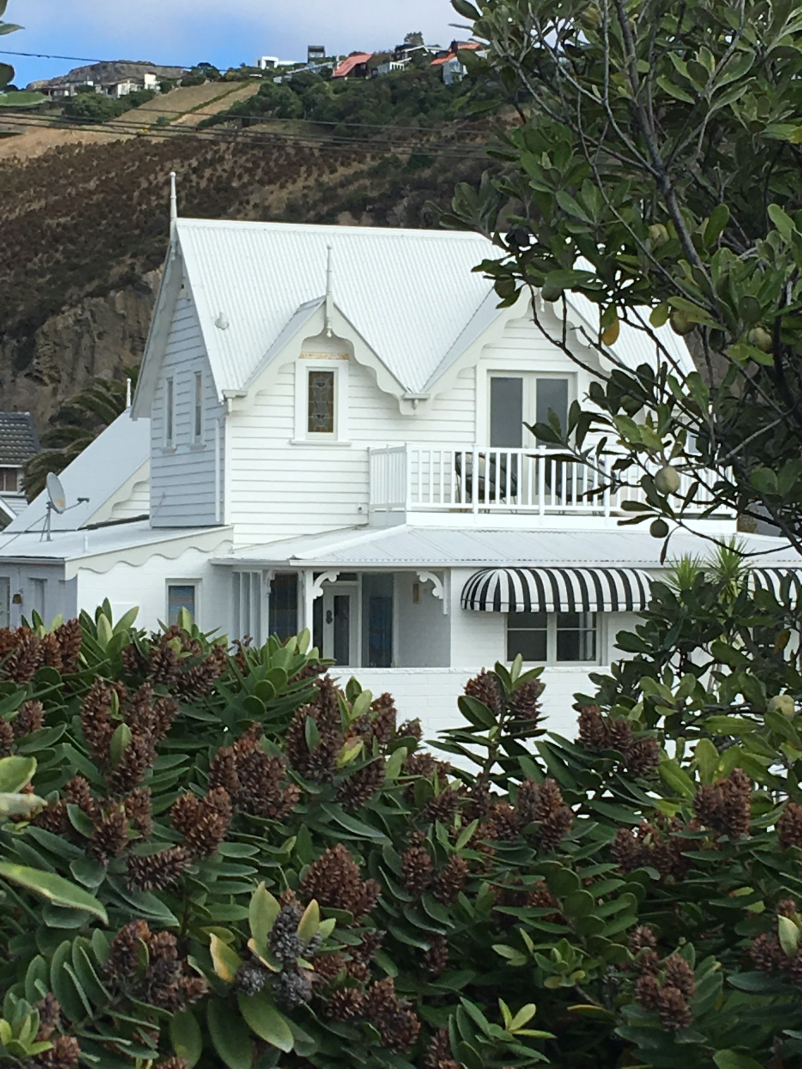
Esplanade formerly Sumner Esplanade. First appears in street directories in 1910. Becomes Esplanade from 1918.
Not much information on the library website. Note John Bird Sumner was a busy man with the number of streets associated with him.Houses are only on one side of the street as there is a walkway above the beach on the other side. This is a pleasant stroll on a nice day. Most of the houses are large older two story wooden villas but there are a few modern places on the street. This was a suburb hit quite badly by the earthquakes.There was one older house that I loved. One modern house had a huge tree in the front garden and I am not sure that I would like having this tree there. i suspect that it is a protected tree. One end of the street has cafes plus Cave Rock. There is several war memorials at this end as well. The other end has a playground and a large clock tower which is undergoing repairs at the moment. The playground was very busy today. I have loaded a photo of a house that I loved. I do prefer older styles of houses.
Nga Mahi Road in the suburb of Sockburn, Christchurch
Nga Mahi Road – Nga Mahi means: the works and was used because this property belonged to the Ministry of Works for many years. Its broader meaning is that this is a place where work is undertaken by the businesses that have established themselves in the subdivision. A through road for a business zone subdivision off Blenheim Road developed in 2002.
Interesting information the library website. This is an industrial area and my photo is of the DOC building where I found a cache. A huge variety of businesses on the road. I watched a huge truck and trailer unit being unloaded and those drivers are so skilled. I haven’t loaded the photo on this website.
Alloy Street in the suburb of Sockburn, Christchurch
Alloy Street – Named after Alloy Steel (NZ) Ltd., Main South Road, Sockburn. Formed alongside this engineering firm. Named in 1958 by the property owner.
Not much information on the library website. Not much on the street. This very much an industrial area and I actually didn’t notice if the business that the street is named after is still there. I took a photo of the most interest looking building which is on the corner of the street which I won’t be loading here.
Plymouth Lane in the Central City,Christchurch
Plymouth Lane – formerly King’s Lane, off Cashel Street, first appears in street directories in 1924. The name change was originally suggested on 24 May 1926 but the official change to Plymouth Lane was not made until 1 September 1948 when 120 streets were re-named. Named after Plymouth in England from whence the First Four Ships departed in September 1850 for Canterbury.
Small amount of information from library website. I visit this area frequently and I have watched the area change a lot over the four years that I have been home. It is very different to the original lane from before the earthquakes. The dark and narrow lane that I wasn’t keen on walking down at night. The Lichfield St car park has been replaced and it looks friendlier than the old one. I wish that I could remember the shops that backed onto Plymouth Lane and I have just had a mental flash. There was one that sold handmade items for a charity and someone that I worked with at Mrs Popes was a volunteer at the shop.
Taupata Street in the suburb of Redcliffs, Christchurch
Taupata Street – Formerly Slater Street. Named after Henry Slater Richards (1860?- 1926). Also formerly William Street. Probably named after Augustus William Bennetts (1860-1936). Re-named . Slater Street and William Street first appear in street directories in 1910. Richards was a land agent and Bennetts was an auctioneer. Both men were members of the syndicate that subdivided part of Redcliffs. Bennetts was later declared bankrupt. Slater Street is first mentioned in The Press in 1892 when a section is advertised for sale there. The two streets were amalgamated and re-named Taupata Street on 1 September 1948 when 120 streets were re-named.
Reasonable amount of information from the library website. Taupata is a native shrub with several English names and most common is mirror bush or New Zealand laurel. This street had mostly older wooden houses. A few small cottage style of houses. The bigger older houses were all behind high fences or had big garages plonked in front so I couldn’t get photos. This was a pity as they looked like interesting houses. There was a few newer houses but not many on this street. When I was a teenager I used to babysit two young girls who lived on this street. They were the daughters of a school teacher friend of my sister.
Beachville Road in the suburb of Redcliffs, Christchurch
Beachville Road – Runs along Redcliffs Beach. In 1922, Beach Street, Causeway Road and Estuary Road “from Sumner Road to The Cutting, Redcliffs” were re-named Estuary Road. Estuary Road was renamed Beachville Road on 1 September 1948.
Small amount of information on the library website. A pleasant street along the edge of the estuary and the name is obvious. A mixture of new and old houses. Most of the older houses were weatherboard and in reasonable condition. The new houses were interesting but for most of them would be like living in goldfish bowls as there was so much glass. There was one that caught my eye and I would love to have taken a photo but there were too many people around. I couldn’t figure out if it was one house with a very strange design or four apartments. I ended up talking to a local couple and they were able to tell me that it was four apartments. Instead of being in a straight row they were diagonal. There is a walkway on the beach side of the road and a few people were fishing. Lovely views here but with global warming I am not sure that I would like to be so close to the estuary.There is a small reserve on the road where there is a cache hidden. At one end there used to be a park but Redcliffs school is being rebuilt at the park. No one is impressed about the decision about rebuilding it here.
Kotzikas Place in the suburb of Wigram,Christchurch
Kotzikas Place – Named after Kypros Kotzikas (1944-). Kotzikas is managing director of United Fisheries. First appears in street directories in 1987
A small amount of information from the library website. This is a short street in a business district in Wigram but I would have thought that it was in Middleton. Obviously the main business on this street is United Fisheries.
Renwick Place in the suburb of Hillmorton,Christchurch
Renwick Place runs off Kinnaird Place and there was no information on the library website. It was a pleasant wee street and most houses were summerhill stone. Two houses had great little forts / tree huts for children. I know a couple who live on this street but couldn’t remember which house they live in. I know them from kindergarten committee days so quite a few years ago. No photos for this street as I felt that a woman gardening was watching me.
Kinnaird Place in the suburb of Hillmorton, Christchurch
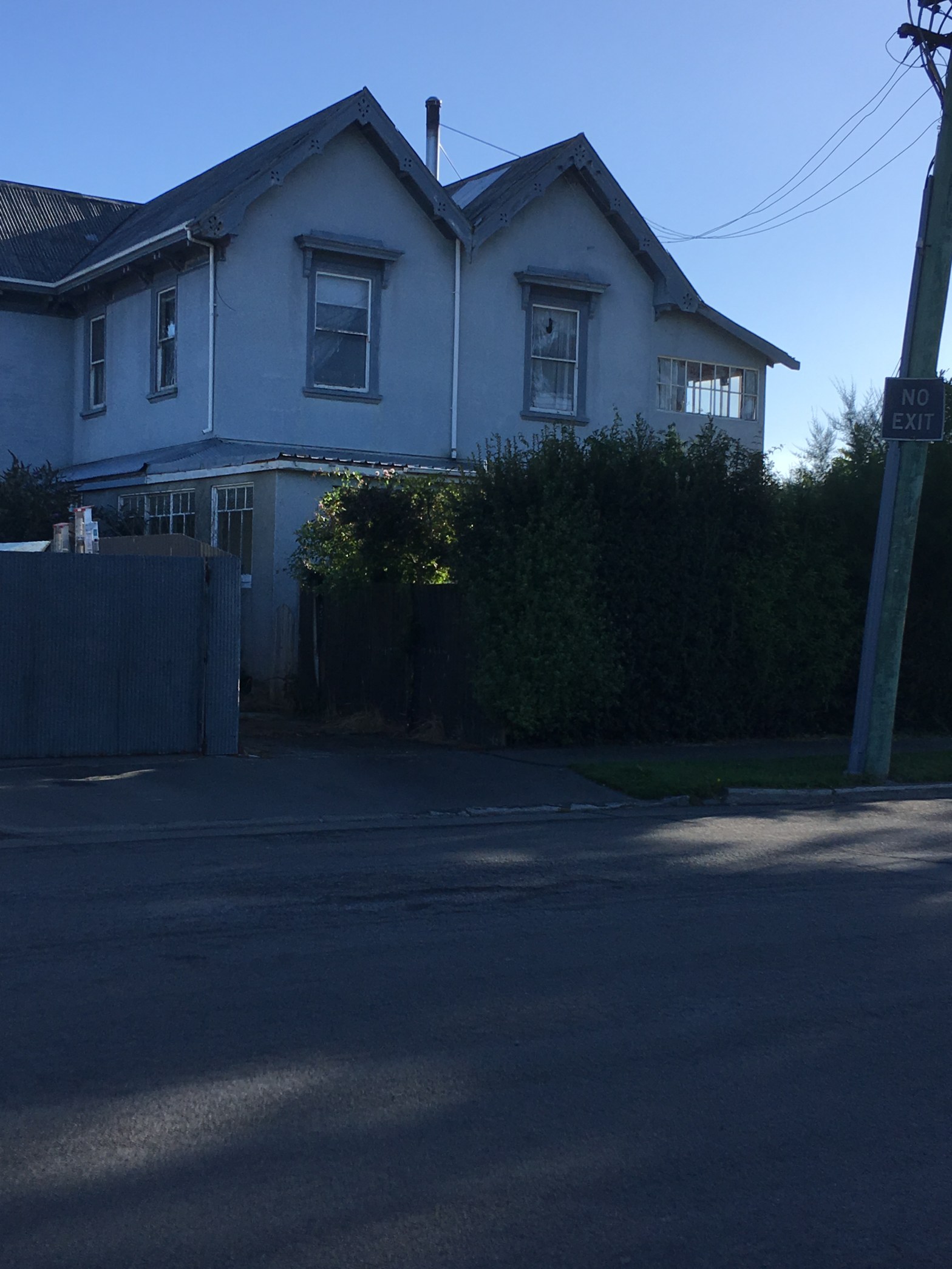
Kinnaird Place – Named after Kinnaird, a house in Lincoln Road. Peter Duncan (1838- 1907), a blacksmith, manufacturing engineer and founder of P & D Duncan Ltd., built the house in 1880 on 5 acres of land leased from the Church of England. The property, in turn, was named after a castle near Duncan’s Brechin birthplace. At the time of his death he was living at a neighbouring property, Airdmhor. From the 1920s, Kinnaird was owned by David Bain of D. M. Bain & Sons until it was subdivided in the 1940s. Named in 1955.
A reasonable amount of information from the library website. Most of the houses are summerhill stone but there are a couple of weatherboard houses. At the end there was a brand new looking flash house plus some new places built off the road that I couldn’t see properly.. I suspect that there had been a couple of old places that had been demolished where the new houses are.
The photo is of an old house which I believe is the house that the street is named after. I remember that the family who lived in this house had children at school the same time as my sons.Please note that the David Bain mentioned on the library website has no connection to the murderer with the same name.
