Scarborough Road in Sumner / Scarborough – Named because it runs through the suburb of Scarborough which, in turn, is named after Scarborough, a seaside resort in Yorkshire, England. First mentioned in The Press in 1908 when it is reported that Mr R. M. Morten’s attorney had requested that the Council should accept dedication of the Scarborough Road. Richard May Morten (1827?- 1909) and his family farmed large areas of land at Mount Pleasant, Scarborough, the Port Hills and Tai Tapu and gave generously to the community.
A small amount of information from the library website and in Gordon Ogilvie’s book it is stated that R M Morten gave the area the name Scarborough and named the road Scarborough Road. Richard May Morton was born in Amersham, Buckinghamshire which is a long way from Yorkshire. He did own the land where the road was formed. A letter to the editor in 1980 has someone claiming that Archie Paterson named the road. Archie Paterson was born in Scotland and he did much of the work developing the road. Archie Donald Paterson went on to start the company British Pavements in 1926. He died in a car accident in 1950 and the inquest reports were interesting as the main witness to the accident was a passenger in a light aircraft. The other name that was associated with the development of the road was Colonel Henry Hobday.
Most of the information on Papers Past was about drainage issues, slips on the road, rocks falling from the cliffs, grass fires and the usual death notices. In 1908 the road still belonged to Richard Morten and it was recommended that he get his attorneys to furnish the council with an indemnity against claims for falling rocks until the council take over the road. In 1909 it was described as a recently constructed road. In 1911 there was talk about extending the road to as far as Godley Head. This obviously didn’t happen. From 1911 onwards there were sections for sale.
In 1927 the hairpin bend was mentioned and this was because someone got stuck on the bend in his car. I am not sure which bend they meant as there are two very sharp bends in this road. I suspect that it might have been the lower one as it was mentioned that the driver froze when his car was up against the cliff. In 1933 the council did blasting here to widen the road and they discovered a cave when blasting. The cave was possibly originally a Maori camp as remains of fish bones and shells were discovered.
The road was tar sealed in 1943 and more sections were for sale from 1944 onwards. The owners of these newer houses in the 1950s complained as the milk vendor wouldn’t deliver milk to their houses. In the 1950s and 1960s there were parking issues and the cars parked were blocking the traffic especially in the busy summer months. In 1965 the residents requested that the road be widened in the upper reaches of the road. There wasn’t any further mention of this so I suspect that it didn’t happen. In 1970s there were several accidents on this road with cars going over the bank or hitting the cliff face. A couple of cars managed to end up in the sea.
Yesterday I had a free day with no commitments as my walking companion client was unable to go out walking. I walked to the bus exchange to catch a bus and ended up in Sumner. I am trying to limit my use of my car and I get free bus trips thanks to the gold card.
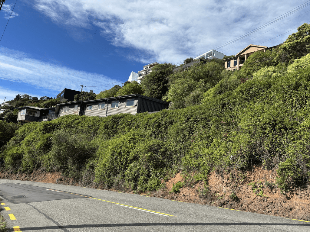
This is an interesting and scary road to walk and will confess that I cheated. I started my walk at the Scarborough Park end and the playground was very busy because of the school holidays. There are the garages under the cliffs and one lot are in good condition but the other group of garages are looking very rundown. The sea and beach is on the other of the road and the sea was busy with surfers. The footpath is narrow and yes I did use bad words at a couple of cyclists. I stood at the bottom of the hill and debated with myself about walking on the road but after watching the cars coming down the hill I decided that it wouldn’t be safe. It is a very narrow road. I went up a track to where there was a sign. Turn left to walk Flowers Track or turn right to walk Scarborough Track. I turned right and followed the narrow walking track. I was walking past the houses as the track was next to the houses. Great views over Sumner from the track. I eventually ran out of track as it had been blocked off yet my map said that it should continue. I was able to walk down to the actual road where I continued walking. It was scary as the road was very narrow and I was walking up the the second sharp bend. It was a bit wider once I got around the bend but I still had to be very careful and several times I stopped and went onto driveways until cars had gone past. I eventually ended up at Nicholson Park where this road ends and becomes Taylors Mistake Road. There are some huge houses here and they would have great views but I wouldn’t like to live here. Besides the houses are well beyond my budget. I walked back down through the park and Flowers Track and ended up chatting with a local. She used to deliver pamphlets and all the people delivering pamphlets refused to do this road because they didn’t feel safe. I don’t blame them.
The houses here cover all decades from 1910 onwards. The older houses start at the bottom of the road and gradually get newer the further up you go. Impossible to get decent photos and I should have taken a photo from The Esplanade. I looked at google maps and took a couple of screenshots from The Esplanade.
Looking at maps is where it gets interesting as Apple Maps and Google maps disagree on where Heberden Ave ends and Scarborough Road starts. For a change I went with Apple Maps and used The Esplanade as the dividing line. One of my paper maps didn’t show Sumner on it and the other one did show Sumner but didn’t have the street names on this part of the streets. One reason that I decided to use The Esplanade as the dividing line was because Scarborough Park is here and the other reason is that the garages under the cliff were mentioned in Papers Past as being on Scarborough Road. The Sumner Coastguard also has a Scarborough Road address and if I went by google maps it shows this building as being on Heberden Ave.