Westminster Street in St Albans and Mairehau – Formerly Green’s Lane and Green’s Road. Named after Green, a local milkman. James Green, of Papanui, is listed in street directories in 1890. Greens Road and part of Shirley Road were amalgamated and re-named Westminster Street. Named after the City of Westminster, a metropolitan borough of London. Green’s thatched-roof, sod house was on the corner of Hills Road and Greens Road. Green’s Lane first appears in street directories in 1892. Shirley Road from Rutland Street up to, and including Green’s Road, was re-named Westminster Street in 1909.
A reasonable amount of information from the library website and nothing that I can add about the name Westminster. This street has been one of the most confusing streets that I have researched. I couldn’t find a James Green who was a milkman and there was a James Green who lived on Springfield Rd but he was a bootmaker. There was a George Green who lived in the area who was a milkman. George Green kept getting fined for short changing customers.
I looked at the Ancestry website, Papers Past and old maps of Christchurch. I thought that the maps would help but it made things even more confusing. I couldn’t find Green’s Lane on any maps but Papers Past had two entries in 1879 with a request for the road to be shingled.
Greens Road is just as confusing as there were two Green Roads within a short distance of each other. There was the Greens Road that ran off the Main North Road and this one became Grasmere Street. There were lots of entries for this Greens Road. Just to further confuse things there was possibly a Greens Road in Addington.
In the 1880s and 1890s there was discussion about who should be responsible for the repairs to the Greens Road bridge and J Mahar was mentioned in connection with the bridge so it will be the Greens Road that became Westminster Street.
In 1909 Shirley Road from Rutland Street to Greens Road to be renamed Westminster Street. I did find a map dated 1903 that shows Shirley Road running between Cranford Street and Toons Road. Toons Road is now Thames Street. This was on a plan for a subdivision in the area.
In 1914 an elderly man dropped dead in the Baptist Church while singing a hymn. The saddest death would have been the young woman who died after a short and painful illness. The inquest said that she died after an illegal miscarriage that was caused by an instrument. The court praised the fact that she hadn’t named the man responsible for her condition and therefore blackening his good name.
In 1927 there was a large block of land to be subdivided and it was known as Rhodes Block and Mairehau Estate. In 1930 St Albans school were raising money to improve the entrance to the school as it was only a narrow footbridge over the St Albans stream. Two issues mentioned in the 1930s were flooding and wandering cows. There was an article in 1933 where a Mr T Allen was interviewed on his 84th birthday and he used to be a market gardener on Westminster Street but he said that it was called Shirley Road those days.
An article in 1932 said that Greens Road to retain its name but Greens Lane in Riccarton to have a name change. Greens Way in the city also to have a name change. Also Greens Road to be changed to Grassmere Street. This was when I looked at maps but this left me even more confused. The map for 1912 showed Westminster Street going from Rutland Street to Hills Road. A map for 1930 also showed Westminster going from Rutland Street to Hills Road. I then found maps for 1922, 1929 and another one for 1930 showing Westminster Street going from Rutland Street to Cranford Street and Greens Road going from Cranford Street to Hills Road. These maps also showed the other Greens Road running off the Main North Road. In 1925 the council wanted suggestions for renaming Greens Road in Papanui, Greens Road in Lower Riccarton and Greens Road in Shirley.
There was mention in 1916 about passengers on the trams were also confused about where Greens Road, Westminster Street and Shirley Road were and they frequently ended up taking the wrong tram.
Especially for a friend I would like to mention that women’s underwear was stolen from the home of Mr T Murfitt. The residents were still complaining about cows in the 1940s as they were herded on the road every Wednesday. Also in the 1940s the Westminster Street tip is mentioned as in 1949 they acquired a bulldozer.
Still complaining about cows in 1952 and the cows were kept in a paddock near the shops on the corner of Hills Road and Westminster Street.
In 1955 it was proposed that the site on the corner of Mahars Road and Westminster Street to be used for new RSA Club rooms. They were still talking about it in 1960 and in 1961 they dropped the idea. In 1958 they talked about establishing the Mairehau playing on the land adjoining the proposed RSA building. Both the RSA and the playground were to be developed on the site where the Westminster Street rubbish dump used to be. There is a playground on this site and it is called Mahars Playground but it also has a boundary on Westminster Street.
The drainage board were still talking about installing sewage in 1956. It is surprising how late some areas of Christchurch were still without sewage.
In 1961 Western Association Football Club was given permission to build club rooms. By 1967 it was called Western Soccer Club Hall. In 1989 land was purchased for a new sports complex. This land was next to the Soccer Club grounds.
In 1971 a new council yard was opened and the Samoa and Assembly of God Hall was opened on the corner of Hills Road and Westminster Street.
Over the decades there were lots of birth and death notices plus lots of accidents especially cyclists.
There was some other random information on Papers Past residents claiming it to be the worst street ever. Issues with wandering cows and horses. One year the residents complained that the road was too boggy and in the same year complained that it was too dry and wanted it watered. The bridge gets mentioned a few times but I am not sure which bridge as there were possibly two bridges on the street. Not that you can tell these days that there were bridges here but one does have a plaque.
The houses on this street cover every decade dating from 1905 up to 2024. Still a large number of older houses.
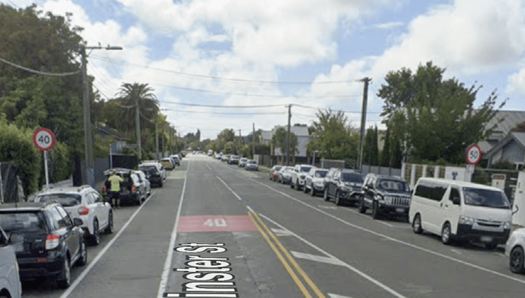
I decided to walk this street on Sunday as it had been in the news last week because of conflicting speed limit signs. The day that the article appeared in the Press was a horrible wet day which is why I waited until the weekend. By this time they had fixed the conflicting sign issue but I was able to get screenshots of them from google maps.
I started my walk at the Rutland Street end where there is a church on the corner of Rutland Street and Westminster Street. Lots of lovely older houses this end of the street and there is a stream that runs alongside the houses here until you reach St Albans School. This is near the Westminster Street and Courtenay Street corner. Westminster Street then curves around so that it is no longer following the stream. A mixture of house styles and ages on this section of the street. At Cranford Street there are shops and it looks the the dairy on the corner is now closed. Between Cranford Street and Hills Road as well as houses there are two big empty sections. One of the empty sections used to have a business called Edgeware Mowers. Next to this empty section there is a drain or stream that now goes under the road but going by the plaque dated 1931 there used to be a bridge here. There is St Albans preschool which has a very colourful fence. On the other side of the road there is Christchurch Park and Westminster Park. The playground is still there and I wonder if the parents realised that it was built on land that was originally a rubbish dump. There is a very overgrown empty section next to the playground and I did peep through the damaged fence. Going by google maps there was a fairly nice house here. It was possibly built on land that was originally the dump and where the RSA was going to be built. Then I came to the shops at the corner of Hills Road. The Samoan Church is still here and I possibly upset a young man here. There were lots of people entering the premises. A couple got out of their car and the man handed a large very heavy looking pot of food to his wife to carry. She was tiny in comparison to her husband and she was struggling to carry it. She asked if he could carry it and he refused. Yes I did tell him that he should carry it. A shocked look from him and a smile from her.
This was a long and confusing street and it took me at least three days of researching.